Dargaville Aerodrome facts for kids
Quick facts for kids
Dargaville Aerodrome
|
|||||||||||||||
|---|---|---|---|---|---|---|---|---|---|---|---|---|---|---|---|
| Summary | |||||||||||||||
| Airport type | Public | ||||||||||||||
| Operator | Dargaville Aero Club | ||||||||||||||
| Location | Dargaville | ||||||||||||||
| Elevation AMSL | 6 ft / 1.9 m | ||||||||||||||
| Coordinates | 35°56′23″S 173°53′37″E / 35.93972°S 173.89361°E | ||||||||||||||
| Runway | |||||||||||||||
|
|||||||||||||||
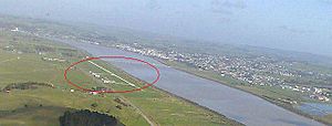
Dargaville Aerodrome (IATA: DGR, ICAO: NZDA) is a small airport. It is located about 2 kilometers (1.2 miles) southeast of the town of Dargaville. This town is in the Northland area of New Zealand.
The airport is home to an active aero club. This club offers lessons for flying advanced microlights. Microlights are very light airplanes. The club also hosts a regular "fly-in" lunch every Saturday. This event brings together pilots from all over New Zealand's North Island.
Dargaville Aerodrome is also a base for special aircraft. These planes are used for "topdressing." Topdressing means spreading fertilizer over farmland from the air. This helps crops and grass grow better. The airport provides aviation fuel (Avgas) for these planes.
This airfield is located at sea level. It sits at the northern end of the large Kaipara Harbour. It is similar to West Auckland Airport at Parakai. That airport is at the southern end of the same harbour, about 80 kilometers (50 miles) away.
Contents
What Happens at the Airport?
Dargaville Aerodrome is a busy place for small planes. It helps connect the local community. It also supports farming in the area.
Flying Lessons and Fun
The Dargaville Aero Club is a big part of the airport. They teach people how to fly. You can learn to fly advanced microlights here. These are small, light aircraft. The club also organizes fun events. Their Saturday "fly-in" lunch is very popular. Pilots fly in from other parts of the North Island to join.
Helping Local Farms
The airport plays a role in local agriculture. It is a base for topdressing aircraft. These planes help farmers by spreading fertilizer. They fly low over fields to make sure crops get what they need. This helps the farms in the surrounding area.
Airport Details
This section gives you some facts about the airport's operations.
Airfield Elevation
The Dargaville airfield is very close to sea level. Its elevation is about 1.9 meters (6 feet) above sea level. This means it is almost at the same height as the ocean.
Runways
The airport has two main runways. Both are called 04/22. This name refers to their direction.
- One runway is 1,000 meters (3,280 feet) long. It is made of rolled limestone. This makes it a strong surface for planes.
- The other runway is 900 meters (2,952 feet) long. It is a grass runway.
Flight Patterns
Pilots follow specific patterns when taking off or landing. This helps keep everyone safe.
- For Runway 04, planes use a right-hand circuit. This means they turn right after takeoff.
- For Runway 22, planes use a left-hand circuit. They turn left after takeoff.
 | Selma Burke |
 | Pauline Powell Burns |
 | Frederick J. Brown |
 | Robert Blackburn |


