Kerikeri facts for kids
Quick facts for kids
Kerikeri
|
|
|---|---|
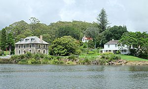
The Kerikeri Mission Station, with the Stone Store at left, St James at rear, and Mission House on the right
|
|
| Country | New Zealand |
| Region | Northland Region |
| District | Far North District |
| Ward | Bay of Islands-Whangaroa |
| Community | Bay of Islands-Whangaroa |
| Subdivision | Kerikeri |
| Settled by Europeans | 1814 |
| Electorates |
|
| Area | |
| • Total | 22.05 km2 (8.51 sq mi) |
| Population
(June 2023)
|
|
| • Total | 8,270 |
| • Density | 375.06/km2 (971.4/sq mi) |
| Postcode(s) |
0230
|
Kerikeri is the second largest town in Northland, New Zealand. It is a popular place for tourists. The town is about 240 kilometres (150 mi) north of Auckland. It is also about 80 kilometres (50 mi) north of Whangārei, Northland's only city.
Kerikeri is sometimes called the "Cradle of the Nation." This is because it was the site of New Zealand's first permanent mission station. It also has some of the oldest buildings in the country.
The town is growing fast. It is known for growing subtropical fruits and plants. Kerikeri is located in the Far North District of the North Island. It sits at the very end of the Kerikeri Inlet. This is an arm of the Bay of Islands, where the Kerikeri River meets the Pacific Ocean.
Early missionaries from Europe first set up the village. They called it Gloucester Town, but this name did not last. The Māori name Kerikeri was written down as Keddi Keddi or Kiddeekiddee at first. Later, the way Māori words were written changed to what we use today.
In 1814, a man named Samuel Marsden bought land in Kerikeri. He bought it from Hongi Hika for 48 axes. This land was for the Church Missionary Society. Chief Ruatara, who was Hongi Hika's nephew, protected the Kerikeri mission station.
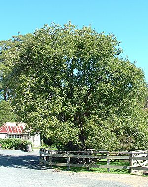
Kerikeri was the first place in New Zealand where grape vines were planted. Samuel Marsden planted 100 vines on September 25, 1819. He wrote in his diary that New Zealand seemed good for growing grapes. In the same year, Charlotte Kemp planted the first citrus trees. New Zealand's first commercial passionfruit farms started here in 1927. Around 1932, the country's first avocados were planted. The plough was also first used in New Zealand at Kerikeri. This happened on May 3, 1820, by Rev. J. G. Butler.
Contents
What Does Kerikeri Mean?
The exact meaning of the name Kerikeri is not fully known. Many different ideas have been shared over the years. It likely comes from the river. John Nicholas visited in 1815 and wrote that the river was called "Tecaddiecaddie" by the local people.
One idea is that "kerikeri" means 'to keep digging'. We know that Māori people had many gardens in the area when Europeans arrived.
Another idea comes from Kerikeri te ana wai. This means "the churning or boiling over of the waters." This would describe the freshwater river falling into the saltwater over the waterfalls. These falls were once higher before they were blasted in the early 1900s for a bridge. However, some Māori say it comes from hukerikeri, meaning "bubbling up." This story is a bit sad. A famous chief, Hongi Hika, is said to have had a child with a captured slave at Kororipo Pā. This was not allowed by the tribe. The baby was put in the water to drown but kept rising to the surface, like "bubbling up."
Today, the waterfalls upriver from the Stone Store Basin are called Wharepuke Falls. But until the 1930s, they were called the Kerikeri Falls. The name Wharepoke came from the large area of native bush nearby. A French doctor, Messier Lesson, visited Kerikeri in 1824. He wrote that Māori people had stomach problems called "gravelle" (gravel), which they called Kiddee Kiddee. He said this word also meant a waterfall.
Some people still claim that the missionaries called the Rainbow Falls "The Kiddikiddi." But this is not possible. Nicholas visited and mentioned Tecaddiecaddie in 1815. However, missionaries Francis Hall and James Kemp were the first Europeans to see Rainbow Falls in 1822.
"It's So Nice They Named It Twice"
Kerikeri has a fun local saying: "It's So Nice They Named It Twice." In the early 1980s, a traveler wrote this in the Visitors' Book at the Kerikeri Youth Hostel. The editor of the local newspaper, the Kerikeri Chronicle, saw it and shared it. It quickly became a popular slogan. Kerikeri has won the "New Zealand's Top Small Town" award from North and South magazine. This slogan and award are now used to promote tourism in the town.
People of Kerikeri
Kerikeri covers about 22.05 km2 (8.51 sq mi). It had an estimated population of 8,270 as of June 2023, . This means there are about 375 people per square kilometer.
| Historical population | ||
|---|---|---|
| Year | Pop. | ±% p.a. |
| 2006 | 5,490 | — |
| 2013 | 6,006 | +1.29% |
| 2018 | 7,185 | +3.65% |
| 2023 | 8,070 | +2.35% |
| The 2006 population is for a larger area of 25.40 km2 | ||
In the 2023 New Zealand census, Kerikeri had 8,070 people. This was an increase of 885 people (12.3%) since the 2018 census. There were 3,870 males, 4,173 females, and 30 people of other genders. The average age was 51.4 years. About 16.1% of people were under 15 years old.
Most people in Kerikeri are European (84.8%). About 18.3% are Māori. Other groups include Asian (6.4%) and Pasifika (3.3%). English is spoken by 97.8% of people. Māori language is spoken by 4.5%. About 30.3% of people were born outside New Zealand.
Many people (55.0%) said they had no religion. About 31.7% were Christian.
Historic Places to Visit
Kerikeri has many important historical sites.
Kororipo Pā
Kororipo pā is what is left of an old Māori fortified village. It is in the Kerikeri basin. In the 1770s, the Ngāi Tawake tribe used this pā to reach the sea. In the 1820s, Hongi Hika used it as a starting point for attacks on other tribes.
Mission House
This building is the oldest wooden structure still standing in New Zealand. It was first called the Mission House. Then, for over 100 years, it was known as Kemp House. Now, it is called Mission House again. Many people visit and photograph this building. Heritage New Zealand looks after it, along with the Stone Store.
The Church Missionary Society built it for Rev John Butler. He was New Zealand's first clergyman and lived there in 1822. In 1832, the mission blacksmith James Kemp and his wife Charlotte Kemp moved in. The Kemps bought the house and land in 1859. They traded land they owned nearby for it.
The Mission House stayed in the Kemp family until 1974. Ernest Kemp, a great-grandson of James and Charlotte Kemp, gave it to the nation.
St. James Church
St James is a wooden church on a hill above the Stone Store. It is the third church built in this area. It is the second church built on this spot, which has great views of the basin. The missionaries' first small church and school was built near the water. It opened on April 19, 1824. In 1829, a new, larger building was put up on the current site. It was 38-by-18-foot (11.6-by-5.5-metre) and made of lath and plaster. It had a town clock, which was later moved to the Stone Store.
The current St James church was built in 1878. It is made of weatherboard and battens. It was made bigger in 1963 to fit more people. In 1968, a strong tornado hit Kerikeri. It moved St James church off its foundation. Services had to be held elsewhere until the church was repaired. The church bell came from HMNZS Black Prince, a ship that served in the Royal New Zealand Navy.
Stone Store
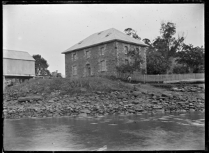
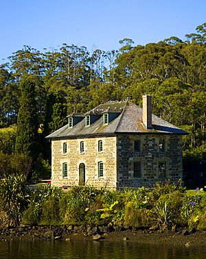
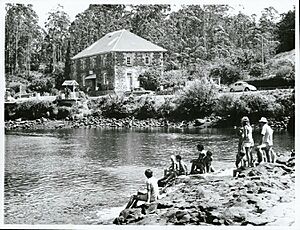
The Stone Store is the oldest stone building in New Zealand. It used to be a storehouse. Building started on April 19, 1832. The stone above the door says 1833. This stone was likely carved by William Parrott, the stonemason. But the building was not finished until mid-1836.
The missionaries used stone because they needed a place that was safe from pests and fire. They also wanted better security from curious Māori. There was a plan to build a mill nearby to make flour from local wheat. The Stone Store would protect this flour. But the mill was never built. The millstones brought from England went to Waimate North instead.
When the Stone Store was being built, many Māori were moving out of the area. By the time it was finished, very few Māori were left in Kerikeri. Some missionaries also felt that Kerikeri was becoming less important for their work. This meant there was less need to store goods there. At the time, some thought the building was a mistake. But today, it is a special part of Kerikeri's history.
Over the years, the Stone Store was damaged by nearby traffic and normal wear. It needed expensive repairs. In the 21st century, a new road was built to take traffic away from the building. This bypass opened on June 23, 2008. The old stone bridge was removed in late 2008. Some local people were unhappy about the bridge being removed. The building has been restored to look like it did originally. However, the clock tower that was on the roof (from the chapel) was removed a long time ago for safety.
Te Ahurea
Rewa's Village was built in the 1970s. It helped raise money to stop a housing development in the Kerikeri basin. Later, the land was bought and became a public park. In 2020, Ngāti Rēhia took over the site and renamed it Te Ahurea. This means 'culture'. They received $1.25 million from the Provincial Growth Fund. Rewa's Village showed what a fishing village was like. Today, Te Ahurea has recreated whare (houses). It also has gardens for growing traditional medicine. You can also take waka (canoe) tours and join cultural workshops. This attraction shows Māori culture from the years 1790–1835.
Arts and Culture
The KOAST (Kerikeri Open Art Studios Trail) is an annual event. It happens every Labour Weekend since 2014. It shows off local artists and art galleries in Kerikeri. In 2019, 40 artists showed their work at 21 studios.
The Turner Centre is a place for performing arts and events. It opened in 2005. It hosts national touring shows and local performances.
Learning in Kerikeri
Kerikeri has several schools.
- Kerikeri High School is the largest school in Northland. It is for students in years 7–13. It has 1,361 students.
- Kerikeri Primary School and Riverview School are primary schools for years 1–6. They have 476 and 401 students.
- Springbank School is a private school for years 1–13. It has 220 students.
- Bay of Islands International Academy is a primary school for years 1–8. It has 63 students.
All these schools teach both boys and girls. School numbers are from February 2024 .
NorthTec polytechnic also has a campus in Kerikeri. This is a place for higher education and training.
Kerikeri Airport
Kerikeri Airport is also called the Bay of Islands Airport. It is 4.2 km from town at 35°16′S 173°55′E / 35.267°S 173.917°E. Air New Zealand has flights from Auckland to this airport. More and more people are using it. In 2017/2018, a record 110,000 passengers used the airport.
The old airport building was not big enough. It also did not meet Air New Zealand's needs. A new $4.75 million building opened on June 16, 2019. It has better areas for arriving and departing passengers. It also has improved baggage screening and collection.
Weather in Kerikeri
| Climate data for Kerikeri (1991–2020 normals, extremes 1945–present) | |||||||||||||
|---|---|---|---|---|---|---|---|---|---|---|---|---|---|
| Month | Jan | Feb | Mar | Apr | May | Jun | Jul | Aug | Sep | Oct | Nov | Dec | Year |
| Record high °C (°F) | 34.3 (93.7) |
33.2 (91.8) |
29.4 (84.9) |
29.6 (85.3) |
25.2 (77.4) |
21.3 (70.3) |
21.9 (71.4) |
21.8 (71.2) |
26.0 (78.8) |
26.4 (79.5) |
29.4 (84.9) |
30.3 (86.5) |
34.3 (93.7) |
| Mean daily maximum °C (°F) | 24.5 (76.1) |
24.4 (75.9) |
22.9 (73.2) |
20.6 (69.1) |
18.1 (64.6) |
15.9 (60.6) |
15.1 (59.2) |
15.6 (60.1) |
17.2 (63.0) |
18.9 (66.0) |
20.5 (68.9) |
22.7 (72.9) |
19.7 (67.5) |
| Daily mean °C (°F) | 19.3 (66.7) |
19.8 (67.6) |
18.3 (64.9) |
16.2 (61.2) |
14.1 (57.4) |
12.0 (53.6) |
11.2 (52.2) |
11.5 (52.7) |
12.8 (55.0) |
14.1 (57.4) |
15.6 (60.1) |
17.8 (64.0) |
15.2 (59.4) |
| Mean daily minimum °C (°F) | 14.1 (57.4) |
15.1 (59.2) |
13.6 (56.5) |
11.8 (53.2) |
10.1 (50.2) |
8.1 (46.6) |
7.3 (45.1) |
7.4 (45.3) |
8.4 (47.1) |
9.4 (48.9) |
10.7 (51.3) |
13.0 (55.4) |
10.8 (51.4) |
| Record low °C (°F) | 4.8 (40.6) |
5.3 (41.5) |
3.2 (37.8) |
1.9 (35.4) |
−0.3 (31.5) |
−1.5 (29.3) |
−2.0 (28.4) |
−0.8 (30.6) |
−0.8 (30.6) |
1.7 (35.1) |
3.0 (37.4) |
3.3 (37.9) |
−2.0 (28.4) |
| Average rainfall mm (inches) | 111.9 (4.41) |
123.0 (4.84) |
135.8 (5.35) |
151.6 (5.97) |
173.8 (6.84) |
198.3 (7.81) |
226.5 (8.92) |
185.6 (7.31) |
159.4 (6.28) |
116.5 (4.59) |
100.2 (3.94) |
141.6 (5.57) |
1,824.2 (71.83) |
| Source: NIWA | |||||||||||||
 | Charles R. Drew |
 | Benjamin Banneker |
 | Jane C. Wright |
 | Roger Arliner Young |


