Purerua Peninsula facts for kids
Quick facts for kids
Purerua Peninsula
|
|
|---|---|

Purerua Peninsula
|
|
| Country | New Zealand |
| Region | Northland Region |
| District | Far North District |
| Ward | Bay of Islands/Whangaroa |
| Electorates |
|
| Area | |
| • Total | 48.19 km2 (18.61 sq mi) |
| Population
(2018 Census)
|
|
| • Total | 201 |
| • Density | 4.171/km2 (10.803/sq mi) |
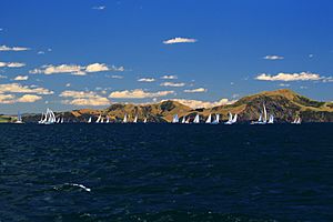
The Purerua Peninsula is a piece of land that sticks out into the water in the Bay of Islands in Northland, New Zealand. It's on the northwest side of the bay. To the south of the peninsula, you'll find Te Puna Inlet. Some small communities on the peninsula include Purerua, Te Tii, and Taronui Bay. Rangihoua Bay is located at the southern end of this peninsula.
In the community of Te Tii, there are two special meeting places called marae. These marae belong to a group of Ngāpuhi people called Ngāti Rēhia. One is called Hiruhārama Hou Marae, which has a meeting house. The other is Whitiora Marae, with its Te Ranga Tira Tanga meeting house. Another local marae, Wharengaere, is a meeting place for the Ngāpuhi groups known as Ngāti Mau and Ngāti Torehina.
Contents
What is the Weather Like on Purerua Peninsula?
| Climate data for Purerua (1991–2020) | |||||||||||||
|---|---|---|---|---|---|---|---|---|---|---|---|---|---|
| Month | Jan | Feb | Mar | Apr | May | Jun | Jul | Aug | Sep | Oct | Nov | Dec | Year |
| Mean daily maximum °C (°F) | 22.9 (73.2) |
23.4 (74.1) |
22.2 (72.0) |
20.4 (68.7) |
18.2 (64.8) |
16.2 (61.2) |
15.4 (59.7) |
15.6 (60.1) |
16.8 (62.2) |
18.1 (64.6) |
19.5 (67.1) |
21.4 (70.5) |
19.2 (66.5) |
| Daily mean °C (°F) | 19.1 (66.4) |
19.8 (67.6) |
18.7 (65.7) |
16.9 (62.4) |
15.0 (59.0) |
12.9 (55.2) |
12.2 (54.0) |
12.3 (54.1) |
13.3 (55.9) |
14.5 (58.1) |
15.8 (60.4) |
17.8 (64.0) |
15.7 (60.2) |
| Mean daily minimum °C (°F) | 15.4 (59.7) |
16.2 (61.2) |
15.1 (59.2) |
13.5 (56.3) |
11.7 (53.1) |
9.7 (49.5) |
9.0 (48.2) |
9.0 (48.2) |
9.8 (49.6) |
10.8 (51.4) |
12.0 (53.6) |
14.1 (57.4) |
12.2 (54.0) |
| Average rainfall mm (inches) | 57.5 (2.26) |
77.0 (3.03) |
94.8 (3.73) |
121.7 (4.79) |
127.6 (5.02) |
138.3 (5.44) |
119.8 (4.72) |
130.0 (5.12) |
104.0 (4.09) |
64.5 (2.54) |
67.4 (2.65) |
91.6 (3.61) |
1,194.2 (47) |
| Source: NIWA | |||||||||||||
Who Lives on Purerua Peninsula?
| Historical population for Purerua Peninsula | ||
|---|---|---|
| Year | Pop. | ±% p.a. |
| 2006 | 150 | — |
| 2013 | 171 | +1.89% |
| 2018 | 201 | +3.29% |
The Purerua Peninsula covers about 48 square kilometers (18.6 square miles). In the 2018 New Zealand census, 201 people lived there. This was an increase of 30 people since 2013, and 51 people since 2006.
There were 75 households, with slightly more males (105) than females (99). The average age of people living there was 43.2 years. About 24% of the people were under 15 years old.
Most people identified as European/Pākehā (67.2%), while 44.8% identified as Māori. A small number (1.5%) were Asian. People could choose more than one ethnicity.
When asked about religion, nearly half (47.8%) said they had no religion. About 30% were Christian, and 11.9% followed Māori religious beliefs.
For those aged 15 and older, about 19.6% had a university degree or higher. The average income was $23,700. Many people worked full-time (43.1%), some part-time (17.6%), and a few (7.8%) were unemployed.
Learning and Schools on the Peninsula
Bay of Islands International Academy is a primary school for students aged 5 to 13 (Year 1 to 8). It opened in January 2013 in the buildings of the old Te Tii School. The school is about 17 kilometers (10.5 miles) north of Kerikeri town.
A school called Purerua Public School existed here since 1906. It even had a ferry service for students from Te Tii. The academy's Māori name is Te Whare Mātauranga o Te Tii, which means 'The House of Knowledge of Te Tii'.
What Does the Academy Teach?
The Bay of Islands International Academy is an authorized IB World School. This means it offers the International Baccalaureate Primary Years Programme. This program focuses on students achieving good grades, learning by asking questions, and understanding different cultures. All students at the academy must learn a second language.
The school serves the areas of Kerikeri, Waipapa, and Purerua. It can teach about 100 students. In December 2015, it had 117 students. There is a specific area where students must live to enroll at the school.
School Facilities and Technology
The Bay of Islands International Academy is built on two hectares (about five acres) of land. It has four classrooms, a library, a resource room, and offices. There's also a swimming pool and play areas for students.
The school has fast internet (100 Mbit/s fibre optic broadband). All learning spaces have WiFi, so students can use the internet easily. After the 2013 census, the school's decile rating changed from 3 to 6. This shows that the families of the students attending the school became more well-off.
Who are Some Famous People from Purerua Peninsula?
- Glenn Colquhoun, a well-known poet.
See also
 In Spanish: Península de Purerua para niños
 | Valerie Thomas |
 | Frederick McKinley Jones |
 | George Edward Alcorn Jr. |
 | Thomas Mensah |

