Aupouri Peninsula facts for kids

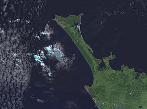
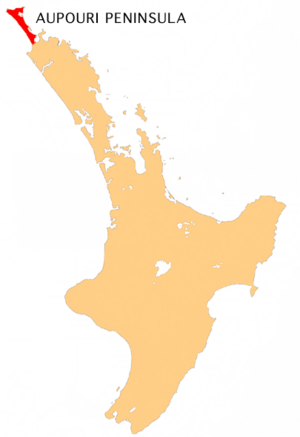
The Aupouri Peninsula is a long piece of land in the far north of New Zealand's North Island. It's like a natural bridge, called a tombolo, connecting to the main island. This peninsula stretches out between the Tasman Sea on its west side and the Pacific Ocean on its east side. It forms the northern part of the Far North District, including places like North Cape, Houhora, and the northern half of Awanui.
Exploring the Aupouri Peninsula
The Aupouri Peninsula is quite unique because it's a peninsula on a much larger peninsula! It's part of the huge Northland Peninsula, which makes up about one-twelfth of New Zealand's land. Near the town of Kaitaia, the Northland Peninsula suddenly gets much narrower. It shrinks from about 60 kilometers wide to just 10 kilometers wide. It stays this narrow for about 100 kilometers as it pushes north.
On the eastern side of the peninsula, you'll find the beautiful Rangaunu Harbour. Beyond that is the Karikari Peninsula and the wide, sweeping Doubtless Bay. The east coast of the Aupouri Peninsula also features Rangaunu Bay in the south and Great Exhibition Bay further north. Closer to the very tip of the peninsula is Parengarenga Harbour, and then North Cape. You can also find Spirits Bay and Tom Bowling Bay at the northernmost part of the land.
One of the most famous features of the peninsula is on its western side. This is the amazing Ninety Mile Beach, which is almost 88 kilometers long!
At its northern end, the peninsula widens to about 30 kilometers. Here, you'll find several capes that seem like the northernmost point of New Zealand's main islands. These include Cape Maria van Diemen, North Cape, and Cape Reinga. However, the actual northernmost point is the Surville Cliffs, which is a few hundred meters further north. Only a few islands in the Three Kings and Kermadec groups are further north in New Zealand.
Even though there are some small towns like Te Hapua, Te Kao, Pukenui, and Kaimaumau, the peninsula doesn't have many people living there. Its population is around 3,900. Because of this, many of the roads are gravel instead of being paved. The main road, State Highway 1, is paved, with the last part finished in 2010. Ninety Mile Beach is officially a highway, but most car rental companies don't allow their cars on it. The closest main town to the very tip of the peninsula is Kaitaia, which is 100 kilometers to the south.
The peninsula is named after Te Aupōuri, one of the Māori tribes that live there.
People of the Peninsula
In 2018, about 3,912 people lived on the Aupouri Peninsula. This was an increase of over 500 people since 2013. There were about 1,404 homes. The population was almost evenly split between males and females.
Most people living here identify as European/Pākehā or Māori. Some people also identify as Pacific peoples or Asian. About 7.8% of the people were born outside New Zealand.
The Aupouri Aquifer
An aquifer is like a huge underground sponge that holds water. The Aupouri Aquifer stretches along the entire Ninety Mile Beach. It also covers low-lying land between Waimanoni and Ahipara, covering a total area of about 75,322 hectares. The Northland Regional Council keeps an eye on the water levels in this underground water source. They also set limits on how much water can be taken out. When people are allowed to take water, they have to check the water levels and watch for any saltwater intrusion, which is when salty ocean water mixes with the fresh groundwater.
There are several small lakes on the Aupouri Peninsula. These include Lake Waiparera, Lake Heather, Lake Ngatu, and Lake Rotoroa. These lakes might be connected to the underground aquifer. This means that if too much water is pumped from the aquifer, it could affect the lake levels. However, there isn't much information available to know for sure.
Recently, there have been concerns from the public about using water from this aquifer for growing avocados. People worry that this might affect the water supply for local communities. They are also concerned about the possible impact on the nearby Kaimaumau wetland, which is an important natural area.
See also
 In Spanish: Península de Aupouri para niños
 | William L. Dawson |
 | W. E. B. Du Bois |
 | Harry Belafonte |


