Houhora facts for kids
Quick facts for kids
Houhora
|
|
|---|---|

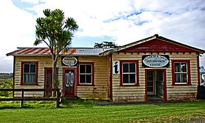
Houhora post office
|
|
| Country | New Zealand |
| Region | Northland Region |
| District | Far North District |
| Ward | Te Hiku |
| Community | Te Hiku |
| Subdivision | North Cape |
| Electorates |
|
| Area | |
| • Total | 26.04 km2 (10.05 sq mi) |
| Population
(2023 census)
|
|
| • Total | 237 |
| • Density | 9.101/km2 (23.57/sq mi) |
Houhora is a small town and harbour located on the east side of the Aupouri Peninsula in Northland, New Zealand. It is about 41 kilometres north of Kaitaia. Nearby places include Waihopo, Te Raupo, Pukenui, Raio, and Houhora Heads, all found along the harbour's southern edge. State Highway 1 goes through most of these places, but not Houhora Heads. Te Kao is 24 km north, and Waiharara is 22 km south.
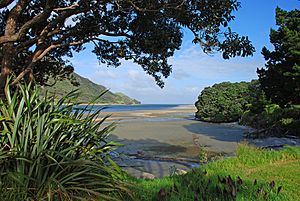
The harbour itself is long and narrow. It is mostly calm and protected. At low tide, you can see large sand banks. A deep channel runs along the southern shore, reaching as far as Pukenui Wharf. Tohoraha / Mount Camel, also called Mt Houhora, is a 236-metre tall hill. It forms the northern entrance to the harbour. The southern entrance is flat.
Contents
History of Houhora
Early Māori Settlement
According to Māori legend, the famous explorer Kupe first saw Houhora Mountain when he arrived in New Zealand. He thought it looked like a whale! Houhora was an important Māori settlement as early as the 14th century. The people living there found food from the sea, like snapper, seals, and dolphins. They also hunted birds, including the now-extinct moa.
European Exploration and Whaling
James Cook was a British explorer. He named Mt Camel, which is on the north side of Houhora Harbour. He did this on December 10, 1769. In his notes, he described it as "a high mountain or hill standing upon a desert shore."
In the 19th century, Houhora Harbour became a place where whalers could get supplies. Local people also went on their own whaling trips in small open boats.
Important Families and Buildings
Three families – the Wageners, Subritzkys, and Yates – moved to the area. They started farms and traded goods. The Subritzky family arrived in New Zealand in 1843. They are thought to be New Zealand's first Polish settlers. They later moved to Australia before settling at Houhora Heads. Their large family home took two years to build in the 1860s. It was later sold to a member of the Wagener family in 1897. Today, this old homestead has been mostly fixed up and visitors can see it.
Near the homestead, W. E. Wagener built the Wagener Museum. This museum had many different kinds of old items. However, it closed in 2003, and many of its treasures were sold.
Shipwreck Rescue
On November 9, 1902, a ship called the SS Elingamite was wrecked. This happened near the Three Kings Islands. The next day, a lifeboat from the ship arrived in Houhora. It carried 52 people who had survived the wreck. One of the local whalers quickly went out to sea. His job was to find any other ships and tell them to go help at the Three Kings Islands. He was successful in his mission.
Kauri Gum Industry
In the late 1800s and early 1900s, the land around Houhora was used for digging kauri gum. Kauri gum is a fossilized resin from kauri trees. It was used to make varnish and other products. By the 1910s, Houhora and Ahipara were important centres for the kauri gum trade.
Population of Houhora
Houhora is a small community. In the 2023 New Zealand census, 237 people lived there. This was an increase of 63 people since the 2018 census. It was also an increase of 93 people since the 2013 census.
| Historical population | ||
|---|---|---|
| Year | Pop. | ±% p.a. |
| 2006 | 111 | — |
| 2013 | 144 | +3.79% |
| 2018 | 174 | +3.86% |
| 2023 | 237 | +6.38% |
People in Houhora come from different backgrounds. About 57% of residents identify as European (Pākehā). About 53% identify as Māori. Some people identify with more than one ethnic group.
Notable People from Houhora
- Lloyd Trigg: He was a pilot in the RNZAF during World War II. He was awarded the Victoria Cross, which is a very brave award.
 | Lonnie Johnson |
 | Granville Woods |
 | Lewis Howard Latimer |
 | James West |


