Karikari Peninsula facts for kids
Quick facts for kids
Karikari Peninsula
|
|
|---|---|

Rangaunu harbour and Rangiputa settlement
|
|
| Country | New Zealand |
| Region | Northland Region |
| District | Far North District |
| Ward | Te Hiku |
| Community | Te Hiku |
| Subdivision | Whatuwhiwhi |
| Electorates |
|
| Area | |
| • Total | 174.44 km2 (67.35 sq mi) |
| Population
(June 2023)
|
|
| • Total | 1,420 |
| • Density | 8.140/km2 (21.08/sq mi) |
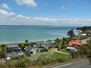
The Karikari Peninsula is a cool place in the far north of New Zealand. It's on the east coast of the Northland Region. To its west is Rangaunu Harbour, and to its southeast is Doubtless Bay.
This peninsula looks a bit like a right angle. It has two main parts. The northern part is rocky and about 17 kilometers long. It used to be an island! Now, it's connected to the main land by a sandy strip called a tombolo, which is about 11 kilometers long. A special place called Puwheke is high up, looking over the northern beaches. It's important to local people.
People Living Here
The Karikari Peninsula covers about 174 square kilometers. As of June 2023, an estimated 1,420 people live here.
| Historical population | ||
|---|---|---|
| Year | Pop. | ±% p.a. |
| 2006 | 942 | — |
| 2013 | 1,164 | +3.07% |
| 2018 | 1,251 | +1.45% |
| 2023 | 1,686 | +6.15% |
In the 2023 New Zealand census, 1,686 people lived on the Karikari Peninsula. This was a big increase of 435 people since the 2018 census. The population has grown quite a lot over the years.
The average age of people living here was about 50.8 years old. About 17% of the people were under 15 years old. Around 28% were 65 or older.
People on the peninsula come from many different backgrounds. Most people are European (Pākehā) or Māori. There are also people from Pacific Islands and Asia. English is spoken by almost everyone. About 14% of people also speak the Māori language.
History and Culture
The main local Māori tribe, or iwi, in this area is Ngāti Kahu. In old Māori stories, a special canoe called the Waipapa first landed in New Zealand at Karikari. This canoe was captained by Kaiwhetu and Wairere.
The two biggest towns on the peninsula are Whatuwhiwhi and Tokerau Beach. Whatuwhiwhi is on the south side of the northern part of the peninsula. Tokerau Beach is at the top of the sandy strip. Maitai Bay and Rangiputa are also popular places for tourists to visit.
Long ago, the sandy strip (the tombolo) had big kauri forests. But by the 1960s, most of the trees were gone. Now, grapes are grown on the northern side of Karikari.
Marae (Meeting Places)
The Karikari Peninsula has two special Māori meeting places called marae. These marae are connected to the Ngāti Kahu tribe.
- Haiti-tai-marangai Marae and its meeting house belong to the Te Rorohuri / Te Whānau Moana family groups.
- Werowero Marae belongs to the Ngāti Tara ki Werowero family group.
Marae are very important places for Māori culture. They are used for gatherings, ceremonies, and learning about history.
 | Bayard Rustin |
 | Jeannette Carter |
 | Jeremiah A. Brown |


