
Bay of Plenty Region facts for kids
Quick facts for kids
Bay of Plenty
Te Moana-a-Toi-te-Huatahi (Māori)
|
|
|---|---|
|
Region
|
|

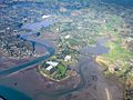
Bay of Plenty farmlands
|
|

Bay of Plenty within the North Island, New Zealand
|
|
| Country | New Zealand |
| Island | North Island |
| Seat | Whakatāne |
| Government | |
| • Body | Bay of Plenty Regional Council |
| Area | |
| • Total | 12,231 km2 (4,722 sq mi) |
| • Land | 12,072.00 km2 (4,661.03 sq mi) |
| Population
(June 2023)
|
|
| • Total | 354,100 |
| • Density | 28.951/km2 (74.983/sq mi) |
| GDP | |
| • Total | NZ$ 21.666 billion (2021) |
| • Per capita | NZ$ 62,673 (2021) |
| Time zone | UTC+12 (NZST) |
| • Summer (DST) | UTC+13 (NZDT) |
| ISO 3166 code | NZ-BOP |
| HDI (2021) | 0.921 very high · 9th |
The Bay of Plenty Region (Māori: Te Moana-a-Toi-te-Huatahi), also called BOP, is a region in the North Island of New Zealand. It's located around a body of water with the same name. The famous explorer James Cook named it the "Bay of Plenty." He saw lots of food supplies in the Māori villages there. This was very different from what he had seen earlier in Poverty Bay.
The Bay of Plenty is home to about 334,140 people. This makes it the fifth-largest region in New Zealand by population. Even though it's only the 11th-largest in land area, it has the third-highest population density. The main cities and towns are Tauranga, Rotorua, and Whakatane.
This region is growing fast! Its population increased by 8.3% between 2018 and 2023. The Bay of Plenty has the second-largest Māori population in New Zealand. More than 30% of its people are of Māori descent. It also has the second-highest number of Māori speakers. There are many Māori tribes (called iwi) here, like Te Arawa, Ngāi Tūhoe, Ngāti Awa, and Te Whakatōhea.
Important industries in the region include growing plants (horticulture), forestry, and tourism. While some parts of the region face economic challenges, the Bay of Plenty has shown strong economic growth. In 2011, it was ranked as one of the best-performing regions for economic development. Tauranga, the biggest business center, was even named New Zealand's top city for economic performance that year.
Contents
A Look at the Past
The Bay of Plenty region we know today was created in 1989. This happened after a big review of local governments across New Zealand. The new region brought together areas like Tauranga, Rotorua, Whakatane, and Opotiki.
How the Region is Run
The Bay of Plenty is divided into smaller areas called territorial authorities. These include the Western Bay of Plenty District, Tauranga City, Whakatāne District, Kawerau District, and Ōpōtiki District. Parts of the Rotorua Lakes District and the town of Rangitaiki are also included.
The Bay of Plenty Regional Council is in charge of important things. They manage how land is used, protect the environment, and handle civil defense. Public health services in the region are provided by Toi Te Ora – Public Health.
Exploring the Geography

The Bay of Plenty Region covers about 12,200 square kilometers of land. It also includes 9,500 square kilometers of coastal marine area. It stretches along the eastern coast of the North Island. This goes from the Coromandel Peninsula in the west to Cape Runaway in the east.
The region also includes several islands in the bay. These are Mayor Island/Tuhua, Mōtītī Island, Whale Island, and the active volcano Whakaari/White Island. Inland, the region reaches into the forest lands around Rotorua and Murupara.
The region has more than 200 square kilometers of lakes. These are known as the Lakes of Rotorua.

Much of the central Bay of Plenty is part of the Taupo Volcanic Zone. This area has many volcanic mountains and lakes. You can also find geothermal areas and fault lines here. The geothermal area near Rotorua is a popular tourist spot. Many hot springs are used for swimming.
A geothermal power plant near Kawerau uses heat from the earth. It can provide a lot of electricity for the eastern Bay of Plenty. Whakaari/White Island is an active volcanic island. It's a popular place for tourists to visit. Major events like the eruption of Mount Tarawera in 1886 and the 1987 Edgecumbe earthquake show the power of the earth here.
Important volcanic mountains in the region include Mount Maunganui, Mount Tarawera, and Mount Edgecumbe/Putauaki. These mountains are also very important to local Māori culture. The Kaimai and Mamaku mountains are on the western edge of the region.
Large areas of native and planted forests are found inland. The Kaingaroa Forest is the world's largest planted forest. It mainly grows radiata pine for timber.
What's the Climate Like?
The Bay of Plenty has warm, humid summers and mild winters. It's one of the warmest regions in New Zealand. Most areas get at least 2,200 hours of sunshine each year.
Summer temperatures usually range from 22 to 26°C. Winter temperatures are typically between 10 and 16°C. It rains more often in winter than in summer. However, tropical storms in summer and autumn can bring heavy rain and strong winds.
People and Population
The Bay of Plenty Region covers about 12,072 square kilometers. It had an estimated population of 334,140 people in 2023. This means there are about 27.7 people per square kilometer.
| Ethnicity | Population |
|---|---|
| New Zealand European |
240,087
|
| Māori |
102,387
|
| Pasifika |
14,202
|
| Asian |
29,262
|
| MELAA |
3,954
|
| Other |
3,558
|
| Historical population | ||
|---|---|---|
| Year | Pop. | ±% p.a. |
| 1991 | 203,982 | — |
| 1996 | 224,364 | +1.92% |
| 2001 | 239,415 | +1.31% |
| 2006 | 257,379 | +1.46% |
| 2013 | 267,741 | +0.57% |
| 2018 | 308,499 | +2.87% |
| 2023 | 334,140 | +1.61% |
In the 2023 census, the population was 334,140. This was an increase of 8.3% since 2018. The median age was 39.7 years. About 19.9% of people were under 15 years old.
The ethnic makeup was 71.9% European/Pākehā, 30.6% Māori, 4.3% Pasifika, and 8.8% Asian. People can identify with more than one ethnicity. The region has smaller numbers of Pasifika and Asian people compared to other regions.

In the 2018 census, 49.9% of people had no religion. 34.6% were Christian. About 3.8% followed Māori religious beliefs.
The median income in 2018 was $29,100. About 46.8% of people aged 15 or older worked full-time. The unemployment rate was 4.5%.
The Bay of Plenty is the fifth-most populated region in New Zealand. It holds about 6.5% of the country's population.
Many towns are found along the coast. The largest is Tauranga and its neighbor Mount Maunganui. The town of Whakatāne is in the middle of the coast. Other towns include Waihi Beach, Katikati, Maketu, Pukehina Beach, and Ōpōtiki.
Most people live in the western and central parts of the coast. The eastern part is mostly hills with fewer people.
Main Towns and Cities
Here are the larger towns and cities in the Bay of Plenty:
| Name | Population (June 2023) |
% of region |
|---|---|---|
| Tauranga | 161,800 | 45.7% |
| Rotorua | 58,900 | 16.6% |
| Whakatāne | 16,850 | 4.8% |
| Te Puke | 10,250 | 2.9% |
| Kawerau | 7,820 | 2.2% |
| Katikati | 5,800 | 1.6% |
| Ōpōtiki | 5,350 | 1.5% |
| Ngongotahā | 5,230 | 1.5% |
| Ōmokoroa | 4,770 | 1.3% |
| Ōhope | 3,270 | 0.9% |
| Waihi Beach | 2,780 | 0.8% |
| Murupara | 2,060 | 0.6% |
| Edgecumbe | 1,820 | 0.5% |
Where Do People Come From?
| Nationality | Population (2018) |
|---|---|
| England | 14,817 |
| India | 6,393 |
| Australia | 5,562 |
| South Africa | 4,299 |
| Philippines | 2,703 |
| China | 1,848 |
| Scotland | 1,770 |
| Netherlands | 1,563 |
| United States of America | 1,479 |
| South Korea | 1,434 |
In 2018, about 18.6% of the people in the Bay of Plenty were born overseas. This is less than the national average of 27.1%. English is the most common language spoken. Te Reo Māori is the most common minority language. It is spoken by 8.6% of the population.
The Region's Economy
The Bay of Plenty's economy was valued at about NZ$17.24 billion in 2019. This was 5.7% of New Zealand's total economy. The average income per person was about $53,700.

The main industries are Agriculture, using natural resources, and tourism. Most of the region (96%) is considered 'rural'. About 22% of the land is used for farming. Another 38% is nature reserves.
The most common types of farming are growing fruits (horticulture), dairy farming, and raising sheep. The region has over 11,500 hectares of land used for growing fruits. These include kiwifruit and avocadoes.
The region also has many coastal, forest, and geothermal resources. Forestry became a very important industry in the 1950s. Trees like radiata pine were planted in the early 1900s. These forests are managed for timber. The timber is sent to the Port of Tauranga for export.
Geothermal activity is a big draw for tourists. Geothermal energy is also becoming a major source of electricity. Tourism is another key industry. It made up 15% of the region's economy between 2000 and 2004.
Tourism and Fun
The Bay of Plenty is a popular holiday spot. This is because of its warm, sunny summers and beautiful public beaches. In 2003, over 645,000 tourists visited the region. This means one out of every three visitors to New Zealand came here.
Rotorua is a favorite place for international visitors. They especially love the geothermal areas and Māori cultural centers. Tauranga is popular for local tourists. It's also becoming more popular with international visitors. Whale watching is a growing attraction. The number of whales, like blue whales and humpback whales, coming into the bay is increasing.
Getting Around
The Bay of Plenty Region has 227 kilometers of railway tracks. It also has 4,460 kilometers of roads. The main railway line is the East Coast Main Trunk Railway. It connects Hamilton to Kawerau through Tauranga. There's also a branch line from Kawerau to Murupara.
The rail networks are only used for moving goods. The Port of Tauranga is a major center for trade. It has good rail and road links to other parts of the region. There are three commercial airports in the Bay of Plenty: Tauranga Airport, Rotorua Airport, and Whakatane Airport.
Most people in the region travel by car. In 2002, there were 189,000 vehicles owned in the region. There were about 1.51 vehicles per household. Public bus services are only available in Tauranga and Rotorua.
Because the Western Bay of Plenty District is growing, roads are getting busier. New highways are being planned and built in Tauranga. These will help connect the city's road network.
Sports in the Bay
The Bay of Plenty is active in many sports. The Bay of Plenty Rugby Union manages the Bay of Plenty Steamers. They play in the Mitre10 Cup. The Steamers also help players move up to the Chiefs team in the Super Rugby competition.
The Waikato/Bay of Plenty Magic team plays netball in the ANZ Championship. The Bay of Plenty is part of the Northern Districts cricket region. It's also part of the Midlands hockey region.
Media and News
Magazines
- LaVita Magazine
- Plenty Magazine
- UNO. Magazine
- Focus magazine
Newspapers
- Weekend Sun/SunLive
- Bay of Plenty Times
- Rotorua Daily Post
- Te Puke Times
- Opotiki News
- Whakatane Beacon
Radio stations
- The Hits Rotorua
- The Hits Bay of Plenty
- 89.4 ZM – Hits
- 90.2 Newstalk ZB – Talk
- 90.5 1XX – Adult Contemporary
- 91.0 Radio Hauraki – Classic Rock
- 91.4 Radio New Zealand Concert – Classical
- 92.6 The Sound – Classic Rock
- 92.9 1XX – Adult Contemporary
- 93.4 More FM – Hits
- 93.7 Bayrock – Rock
- 97.7 and 99.3 Q97 – Hits
- 94.2 The Rock FM – Rock
- 95.0 Classic Hits – 80s / 90s
- 97.4 Coast – Easy Listening
- 99.0 Radio Sport – Sports
- 99.8 The Edge – Hits
- 100.1 Bayrock – Rock
- 101.0 Radio New Zealand National – Talk
- 105.4 BollyBOP FM – Hits
Television
- TV Central (Freeview Channel 30) – Bay of Plenty & Waikato (shut down in April 2015)
- TV Rotorua-Rotorua (shut down in December 2013)
- Geyser Television-Rotorua (shut down in December 2013)
Famous People from the Bay of Plenty
- Te Purewa (?–1842?), a tribal leader, war leader, and peacemaker.
- Maharaia Winiata (1912–1960), a New Zealand tribal leader, minister, teacher, and community leader.
Sister Regions
- Jiangxi Province, China
Images for kids
-
Bay of Plenty farmlands
See also
 In Spanish: Región de Bay of Plenty para niños
