
Mount Maunganui facts for kids
Quick facts for kids
Mount Maunganui
|
|
|---|---|
|
Suburb
|
|
.jpg)
Mount Maunganui in autumn
|
|
| Country | New Zealand |
| Region | Bay of Plenty |
| Local authority | Tauranga |
| Electoral ward | Mauao/Mount Maunganui General Ward |
| Area | |
| • Land | 988 ha (2,441 acre) |
| Population
(June 2023)
|
|
| • Total | 7,450 |
| Airport(s) | Tauranga Airport |
|
|
||
Mount Maunganui (pronounced "ma-oong-a-noo-ee") is a lively suburb of Tauranga, a city in New Zealand. It sits on a narrow piece of land, like a finger, pointing out into the sea. This area was once its own town. It joined Tauranga after the Tauranga Harbour Bridge was built in 1988. This bridge made it much easier to travel between the two places.
The name Mount Maunganui also refers to a large hill nearby. This hill is actually an old lava dome. It formed millions of years ago from a type of rock called rhyolite. Its official Māori name is Mauao. Many people in New Zealand simply call it The Mount. The New Zealand Ministry for Culture and Heritage says Maunganui means "large mountain".
Contents
- Exploring Mount Maunganui's Geography
- Who Lives in Mount Maunganui?
- A Look Back at Mount Maunganui's History
- Marae: A Place of Gathering
- What Makes Mount Maunganui Special?
- Sports and Events in Mount Maunganui
- Artificial Reef: A Surfing Experiment
- Mount Maunganui's Climate
- Schools in the Area
- Images for kids
Exploring Mount Maunganui's Geography
Mount Maunganui is built on a special landform called a tombolo. This is like a natural bridge made of sand. It connects the big hill, Mauao, to the mainland. Because of this, people living here have two types of beaches very close by. There's a calm harbour beach called Pilot Bay. Then there's an ocean beach with great waves for surfing. At the base of Mauao, the distance between these two beaches is only a few blocks.
The ocean beach starts at Mauao on its western side. It stretches to the east where a human-made land bridge connects to Moturiki Island.
Next to Mount Maunganui, to the southeast, is Papamoa Beach. This is another large suburb of Tauranga. Papamoa Beach has more people living there. However, Mount Maunganui has more shops and businesses. Both suburbs are separated from the rest of Tauranga by the Tauranga Harbour. Only two bridges and a winding road connect them to the city centre.
Mauao: The Mountain That Gives the Town Its Name
Mauao, or The Mount, is a large hill that stands tall over the town. It is 232 metres (761 ft) high. It looks impressive in the mostly flat area around it. According to Māori legends, Mauao was once a slave to another mountain.
Long ago, Mauao was a Māori pā, which was a fortified village. You can still see the remains of old trenches on its slopes. There are also ancient shell middens, which are piles of shells from old meals. Today, Mauao is a popular spot for everyone. You can walk around its base or climb to the top. From the summit, you get amazing views of the coastline. You can also see the Kaimai Range mountains to the west.
Who Lives in Mount Maunganui?
Mount Maunganui covers about 9.88 km2 (3.81 sq mi). As of June 2023, about 7450 people live here.

In 2018, Mount Maunganui had 6,510 residents. This was an increase from previous years. There were slightly more males than females. About 14% of the people were under 15 years old. Most people were between 30 and 64 years old.
Most residents (about 90%) are of European background. About 13% are Māori. Smaller groups include Pacific peoples and Asian people. About 20% of the people living here were born outside New Zealand.
Many people in Mount Maunganui do not have a religious belief (about 58%). About 32% are Christian. Smaller numbers follow other religions like Hinduism or Buddhism.
A Look Back at Mount Maunganui's History

Mount Maunganui was often just called Maunganui until 1907. When it was time to officially name the area, Maunganui was thought to be too similar to other towns. An early settler suggested other names, and Rakataura was chosen. However, people kept using the unofficial name, Maunganui. The name Mount Maunganui came about later. It was part of a plan by early developers to change the town's official name. The current name is a bit funny because maunga means "mountain" in Māori, and nui means "big". So, "Mount Maunganui" basically means "Mount Big Mountain"!
In the 1950s, Mount Maunganui fought hard to stay separate from Tauranga. But when the harbour bridge was finished in 1988, it became part of Tauranga.
Anne Speir was the first professional female lifeguard at the beach. She later became a television producer. The very first house built in Mount Maunganui still stands today. It was built in 1906 by J.C. Adams, an early settler. This historic house is located at 4 Adams Avenue.
Marae: A Place of Gathering
The local Whareroa Marae and Rauru ki Tahi meeting house is an important place. It is a gathering spot for the Ngāi Te Rangi hapū (sub-tribes) of Ngāti Kuku and Ngāi Tukairangi. A marae is a special place for Māori people to meet, celebrate, and hold important events.
What Makes Mount Maunganui Special?


Many people see Mount Maunganui as a fun coastal resort town. It's famous for its great surfing waves. However, some parts of the beach can be dangerous for swimming. The harbour bridge, opened in 1988, made it easy to get to Tauranga. A second bridge was built in 2009. This helped with traffic as the area grew.
Mount Maunganui is also home to a large port. This is where big ships come to load and unload containers. A railway line also runs through the suburb, connecting to the main railway network.
You can also find the popular Bayfair Shopping Centre here. It's one of the biggest shopping malls in the North Island outside of Auckland and Wellington.
Mount Maunganui is a very popular place to visit for New Year's Eve. Over 20,000 people come to celebrate around the main beach. Many cruise ships visit the port each year, bringing lots of tourists to the suburb.
Sports and Events in Mount Maunganui

The suburb has a cricket ground called Bay Oval. This stadium has hosted big international cricket matches. It even held the final of the ICC Under 19 Cricket World Cup in 2018.
Every year, Mount Maunganui hosts many sports events. These include the Northern Regional Surf Championships. Other events are the NZ Under 14 Ocean Athlete Championships, the Pro Volleyball Tour, and The Port of Tauranga Half Ironman triathlon.
Artificial Reef: A Surfing Experiment
New Zealand's first artificial reef was built at Mount Maunganui. This was an attempt to create better surfing waves. However, the project faced problems. It cost more money than expected. Also, local surfers were disappointed because the waves weren't very good. The reef was even blamed for creating dangerous rips. Because of these issues, the artificial reef has now been removed.
Mount Maunganui's Climate
The weather in Mount Maunganui is mild and subtropical.

- Summer (January/February): Temperatures are usually between 20°C and 30°C.
- Winter (June/July): Temperatures are cooler, around 10°C to 15°C.
- Frosts: There are about 12 frosts per year, with temperatures dropping to -1°C or -2°C.

- Rainfall: The area gets about 1280mm of rain each year.
- Sunshine: Mount Maunganui enjoys at least 2200 hours of sunshine annually.
- Beach Water Temperature:
- Summer: Around 21°C.
- Winter: Around 14°C.
Schools in the Area
Mount Maunganui Primary School is a school for students in Year 1 to 6. It has about 390 students as of February 2024.
Other schools, like Mount Maunganui College and Mount Maunganui Intermediate, are located in the nearby suburbs of Omanu and Arataki.
Images for kids
-
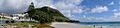
Panorama of Mount Maunganui and the Main Beach
-
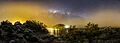
A Panoramic view of Mount Maunganui from Moturiki Island at night with milkyway setting in the background
