
Mount Maunganui (mountain) facts for kids
Quick facts for kids Mount MaunganuiMauao |
|
|---|---|

Mount Maunganui
|
|
| Highest point | |
| Elevation | 232 m (761 ft) |
| Geography | |
| Location | Tauranga Bay of Plenty, North Island, New Zealand |
| Topo map | NZMS 260 sheet: U14 |
| Geology | |
| Age of rock | 2.35 ± 0.06 Ma |
| Mountain type | Lava dome |
| Climbing | |
| Easiest route | Trail |
Mount Maunganui, also called Mauao, is a special mountain in New Zealand. Locals often call it The Mount. It's a 232-meter (760-foot) volcanic dome. This means it's a hill made from thick, slow-moving lava.
Mauao sits at the end of a peninsula in the Tauranga suburb of Mount Maunganui. It's right next to the entrance of Tauranga's harbor.
For the local Māori, Mauao is considered tapu, or sacred. It's a very important part of their stories and history. Today, Māori tribes own the mountain. They work with the Tauranga City Council to look after it.
Mauao is open for everyone to visit. It's a popular spot for walks, jogging, and even activities like parasailing. Sometimes, fires or storms have damaged the tracks. When this happens, new plants are put in and the tracks are fixed.
Contents
What's in a Name?
The name 'Maunganui' means 'big mountain' in English. It's a simple way to describe this large hill.
The other name, 'Mauao', has a deeper meaning. It means 'caught by the morning sun'. This name comes from an old Māori legend.
The Legend of Mauao
Long ago, there was a lonely hill. This hill didn't have a name. It felt sad because it was just a servant to Otanewainuku, the most important mountain in the Tauranga area.
Nearby lived a beautiful hill named Puwhenua. She was covered in lovely forests. The nameless hill wanted Puwhenua to like him. But Puwhenua already loved Otanewainuku.
Feeling heartbroken, the nameless hill decided to drown himself in the Pacific Ocean. He called for help from his friends, the patupaiarehe. These were magical fairy people who lived in the forest and only came out at night.
When night came, the patupaiarehe tied many ropes around the nameless hill. They began to pull and heave with all their might. The ground shook as they dragged the hill from its spot. As they pulled, they dug out a valley, which became the Waimapu River.
They kept pulling the hill towards the great ocean. But as they got close, the sun began to rise. The patupaiarehe were people of the night. They couldn't be in the sunlight, so they had to quickly retreat back into the forest.
The nameless hill was left right at the entrance to Tauranga Harbour. He was "caught by the dawn." Because of this, the patupaiarehe gave him the name Mauao. Over time, Mauao became a very important and respected mountain. It is now a symbol for all the tribes of Tauranga Moana.
How Mauao Was Formed
Mauao is a type of volcano called a lava dome. It's made from a thick kind of lava that doesn't flow far. Instead, it piles up around the vent, forming a dome shape.
This mountain is part of the Tauranga Volcanic Centre. It last erupted about 2.35 million years ago. That's a very long time!
Early History of Tauranga and Mauao
The name Tauranga means 'place of rest' or 'anchorage'. It was a good place for early travelers to stop.
The first people known to live in the Tauranga area were the Purukupenga and the Ngamarama. Many different groups of people came through in their waka (canoes). Some stayed and made the area their home.
Important Canoes and Leaders
The Tainui canoe made a short stop here. The Te Arawa canoe landed at Maketu, and some of its crew settled near Tauranga Harbour.
Then the Takitimu canoe arrived in Tauranga Harbour. Its captain, Tamatea Arikinui, climbed to the top of Mauao. He offered special prayers and buried the mauri (life force) of his people there. This made Mauao even more sacred.
Tamatea built a pa (a fortified village) on a nearby hill called Maungatawa. His people, the Ngati Ranginui, lived there.
Battles and Changes
Later, the Ngaiterangi tribe wanted a permanent home. Around the year 1700, they attacked the Ngati Ranginui pa on Mauao. The Ngaiterangi took control of the pa in a battle known as the 'Battle of the Kokowai'.
Archaeologists have found signs of three different pa sites on and around Mauao. The last major battle at Mauao happened in 1820. The Ngapuhi tribe, armed with muskets, fought the Ngaiterangi. After this battle, the large pa site on Mauao was not used again. Soon after, peace was made between the tribes.
The MV Ranui Incident
On December 28, 1950, a passenger boat called the Ranui was near the base of Mauao. An unusually large wave hit the boat, pushing it onto a rock. The boat capsized and broke apart.
There was only one survivor from the 23 people on board. Today, a brass plaque is placed near the rocks. It serves as a memorial to those who were lost.
Who Owns Mauao Now?
For many years, Mauao was owned by the Crown (the government). However, after the land wars of 1863, the local Māori tribes had lost control of the mountain.
On May 14, 2008, the New Zealand Parliament officially gave ownership of Mauao back to the Ngāi Te Rangi, Ngati Ranginui, and Ngati Pukenga iwi (tribes).
Now, these iwi work together with the Tauranga City Council to manage Mauao. They make sure it is cared for and remains a special place for everyone.
Images for kids
-
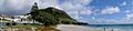
Panorama of the mountain and the Main Beach
