
Papamoa facts for kids
Quick facts for kids
Papamoa
Māori: Te Rae o Pāpāmoa |
|
|---|---|
|
Suburb
|
|

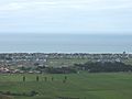
Looking towards Mayor Island down Domain Rd from the Papamoa Hills
|
|

Papamoa
Māori: Te Rae o Pāpāmoa Location in New Zealand
|
|
| Country | New Zealand |
| Local authority | Tauranga |
| Electoral ward |
|
| Area | |
| • Land | 2,580 ha (6,380 acre) |
| Population
(June 2023)
|
|
| • Total | 35,810 |
|
|
||
Papamoa or Papamoa Beach is a lively suburb in Tauranga, New Zealand. It's located about 11 kilometres from the city centre. Papamoa is the largest residential area in Tauranga, known for its beautiful long beach.
It is bordered by Arataki and Mount Maunganui to the west. To the east, you'll find the Kaituna River. State Highway 2 forms its southern border.
Contents
Discovering Papamoa's Rich History and Culture
Papamoa has a fascinating past, especially its connection to the Māori people. Māori communities settled here around the year 1400 CE. They built a large fortified village, called a pā, which overlooked the rich plains and the sea.
For about 300 years, the people of Papamoa thrived. They grew crops like kūmara (sweet potato) and fished from the abundant coast. They would move their settlements around based on the kūmara growing cycle and how fertile the soil was.
Papamoa's Beach and Modern Growth
Papamoa boasts a stunning 16-kilometre stretch of white sandy beach. It runs from the border with Mount Maunganui all the way to the Kaituna River. For a long time, Papamoa was mostly a rural area with farms.
Widespread settlement by Pākehā (New Zealanders of European descent) didn't really begin until the early 1960s. Since then, many of Papamoa Beach's wide-open paddocks have been developed into homes and communities. Today, Papamoa is one of the fastest-growing suburbs in Tauranga. Many new housing areas are being built all the time. It's a popular spot for fishing, surfing, and relaxing holidays.
Understanding Papamoa's Marae and Community
A very important cultural place in Papamoa is the Mangatawa or Tamapahore Marae. A marae is a special meeting ground for Māori communities. Its Tamapahore meeting house is where the Ngāi Te Rangi hapū (sub-tribe) of Ngā Pōtiki gather. It's a place for important events, discussions, and celebrations.
Understanding the Name: Papamoa vs. Papamoa Beach
It can be a bit confusing, but the area people usually call "Papamoa" today is actually "Papamoa Beach." The name "Papamoa" itself refers to an area further inland, closer to the Papamoa Hills. That inland area is managed by the Western Bay of Plenty District Council.
The Papamoa (Beach) area can be divided into two parts: Papamoa East and Papamoa West. Legally, Domain Road separates these two areas. However, many local people think Papamoa East starts on the eastern side of Parton Road. Back in the 1970s and 1980s, Papamoa East was seen as a more alternative place to live, a bit like the Coromandel Peninsula.
Papamoa's Growing Population and People
Papamoa covers an area of about 25.80 square kilometres. As of June 2023, it has an estimated population of 35810 people. This means there are about 1388 people living in each square kilometre.
| Historical population | ||
|---|---|---|
| Year | Pop. | ±% p.a. |
| 2006 | 16,176 | — |
| 2013 | 19,344 | +2.59% |
| 2018 | 25,272 | +5.49% |
Papamoa has seen a lot of growth! For example, between the 2013 and 2018 censuses, its population grew by over 30%. This shows how popular the area has become.
Who Lives in Papamoa?
The people of Papamoa come from many different backgrounds. In 2018, most residents identified as European/Pākehā. There's also a significant Māori population, along with people from Pacific Islands, Asia, and other parts of the world.
About 22.7% of Papamoa's residents were born overseas. This is a bit lower than the national average for New Zealand.
When it comes to beliefs, many people in Papamoa don't have a specific religion. However, a good number are Christian. There are also smaller groups who follow Māori religious beliefs, Hinduism, Islam, Buddhism, and other religions.
Papamoa's Economy and Shopping
Papamoa Beach has a large area dedicated to shops, mostly located west of Domain Road. There's also a small section where industrial businesses operate, found to the east of Parton Road.
Where to Shop in Papamoa
- Papamoa Plaza: This big shopping centre opened in 1997. It has 14,120 square metres of space and offers 650 parking spots. You can find 39 different shops here, including major stores like Countdown and The Warehouse.
- Fashion Island: This shopping centre is a bit smaller, covering 3,315 square metres. It opened in 2006 and has 20 stores.
Learning in Papamoa: Schools and Education
Papamoa has a range of schools for students of all ages.
Secondary School
- Papamoa College: This is a state secondary school for students from Year 7 to Year 13 (ages 11-18). It opened in 2011 and has a roll of 1,464 students.
Primary Schools
Papamoa has several state primary schools for students from Year 1 to Year 6 (ages 5-10):
- Papamoa Primary School: This school has a roll of 526 students.
- Golden Sands School: Established in 2011, this school has 435 students.
- Te Okuroa Drive School: This new school opened in 2021.
- Tahatai Coast School: Established in 1996, it has a roll of 748 students.
- Te Akau ki Papamoa Primary School: This school opened in 2000. It used to teach Year 1 to 8 students, but now focuses on Year 1 to 6 since Papamoa College opened. It has a roll of 468 students.
- Te Kura Kaupapa Māori o Te Kura Kokiri: This is a special state primary school where students learn mostly in the Māori language (Māori language immersion). It has a roll of 275 students.
- Suzanne Aubert Catholic School: This state-integrated Catholic primary school opened at the start of 2021.
Getting Around Papamoa: Transport Options
The main way to get around Papamoa Beach using public transport is by bus. The suburb is served by three 'Bay Hopper' bus routes:
- Route 30: Connects Mount Maunganui to Papamoa.
- Route 33: Travels between Tauranga and Papamoa, crossing the Harbour Bridge.
- Route 36: Also connects Tauranga to Papamoa, but goes via the Maungatapu Bridge.
Images for kids
-
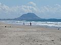
Mt Maunganui from Papamoa Beach
-
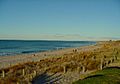
Papamoa Beach from the Papamoa Domain
-
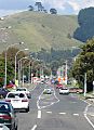
The Papamoa Hills from Domain Rd
-
Looking towards Mt Maunganui from the Papamoa Hills
-
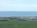
Looking down at Papamoa from the top of the Papamoa Hills
-
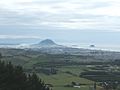
Looking towards Parton Rd and Motiti Island from the Papamoa Hills


