Maungatapu Bridge facts for kids
Quick facts for kids Maungatapu Bridge |
|
|---|---|
| Carries | Motor vehicles |
| Crosses | Tauranga Harbour |
| Locale | Tauranga City, New Zealand |
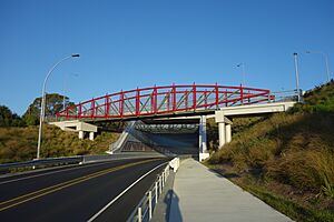
The Maungatapu Bridge is a beam bridge in New Zealand. It crosses the Tauranga Harbour, connecting the Matapihi and Maungatapu areas. This important bridge opened in 1959.
The bridge is 316 metres long and 10 metres wide. It has two lanes for cars and a special path for people to walk on. While it used to carry two main highways, today it mostly carries State Highway 29A.
Contents
History of the Maungatapu Bridge
Since it was built in 1959, the Maungatapu Bridge has seen some changes. For example, in 2014, a new safety barrier was added. This project took about two months to complete.
More recently, the bridge has been part of a bigger redevelopment plan. This plan is happening in four main steps. So far, three of these steps have been finished.
Current Bridge Improvements
Before recent construction, there were many traffic problems on the Maungatapu Bridge. As more cars used the bridge, people worried about safety. Citizens who drove across it often noticed the traffic getting much heavier.
For example, in June 2016, a car crash involving several vehicles caused injuries. The road had to be closed, which led to big traffic jams. Another similar crash happened in November 2018. These events showed that changes were needed for the bridge.
Maungatapu Bridge Construction Stages
The Maungatapu Bridge is currently undergoing construction to make it safer and improve traffic flow. The Maungatapu underpass, which goes under the bridge, was reopened on June 22, 2018.
In July 2018, the New Zealand Transport Agency did a special trial. For ten days, they closed the straight-through option on the bridge. Drivers could only use the roundabout. This trial helped planners gather information. They wanted to see how the new design affected traffic flow and travel times.
The construction project has four stages. The first stage added new street lights. The second stage improved the intersections where roads meet. The third stage involved collecting data to help design the best new layout. The final stage is still being worked on.
Future of the Maungatapu Bridge
The Maungatapu Bridge has been under construction since 2008. The first stage involved adding street lights to the roundabouts. The second stage improved the intersections. The third stage focused on finding the best ways to improve traffic flow and safety.
The project is now in its fourth and final stage. This stage will make the Maungatapu underpass two lanes instead of one. A new bridge will also be built over the Kaitemako Stream. Part of this new design will connect Welcome Bay Road to the Hairini highway.
The New Zealand Transport Agency hopes these changes will make traffic flow better. They also want to ensure the safety of drivers and people walking on the bridge. The completion date for this big project is not yet known.
Interesting Facts About the Area
The name Maungatapu comes from the native language of New Zealand. It means "sacred mountain." The bridge is named after a mountain in the area.
The Maungatapu Bridge is located in the city of Tauranga. Tauranga is a popular place for holidays. It is known for its beautiful beaches and scenery.
One famous spot in Tauranga is Mount Maunganui. This mountain offers amazing views of the area. It also provides many fun activities for both locals and visitors. These activities include whale watching, swimming, surfing, and rock climbing.
 | Laphonza Butler |
 | Daisy Bates |
 | Elizabeth Piper Ensley |


