
Whakaari/White Island facts for kids
Quick facts for kids Whakaari/White Island |
|
|---|---|
| Whakaari (Māori) | |

Whakaari/White Island
|
|
| Highest point | |
| Elevation | 321 m (1,053 ft) |
| Prominence | 321 m (1,053 ft) |
| Geography | |
| Location | Bay of Plenty, (off) North Island, New Zealand |
| Geology | |
| Mountain type | Stratovolcano |
| Volcanic arc/belt | Taupo Volcanic Zone |
| Last eruption | 9 December 2019 |
Whakaari/White Island (also known as just White Island) is an active volcano in New Zealand. It is located about 48 km (30 mi) off the east coast of the North Island, in the Bay of Plenty. This volcano is New Zealand's most active cone volcano. It has been forming through constant volcanic activity for the past 150,000 years.
The closest towns on the mainland are Whakatane and Tauranga. Whakaari has been releasing volcanic gas almost continuously since James Cook saw it in 1769. It erupted non-stop from December 1975 to September 2000. This was the longest eruption episode ever recorded, according to GeoNet. It also erupted in 2012, 2016, and 2019.
The island is roughly round, about 2 km (1.2 mi) wide. It rises to 321 m (1,053 ft) above sea level. The island covers an area of about 325 ha (800 acres). The part of the island you can see is just the top of a much bigger submarine volcano. This underwater volcano rises up to 1,600 m (5,249 ft) from the nearby seafloor. People used to mine sulphur on the island, but this stopped in the 1930s. In 1914, ten miners died when part of the crater wall collapsed.
Today, the main activities on the island are guided tours and scientific research. You can only visit the island if you are part of a tour run by an approved company. A large eruption happened on 9 December 2019. This event caused the deaths of fifteen people and injured many others, mostly with severe burns. Forty-seven people were on the island when it erupted. A second eruption happened soon after the first.
Contents
Understanding Whakaari's Volcanic Activity

Whakaari/White Island is part of the Taupo Volcanic Zone. Its eruptions have created lava flows made of andesite and dacite. It has also had explosive eruptions of ash and fast-moving pyroclastic flows (hot gas and rock). Because it is so active and easy to reach, it attracts many scientists and tourists.

Volcanologists from the GeoNet Project constantly watch the volcano. They use surveillance cameras to monitor its activity. They have also put special equipment on the crater walls. This includes survey pegs, magnetometers, and seismography tools. These tools help give early warnings about earthquakes.
The island usually has an alert level of 1 or 2 on a scale of 0 to 5. Level 2 is the highest alert before an eruption. It means there is "moderate to heightened volcanic unrest" and a "potential for eruption hazards." The alert level was changed from level 1 to level 2 on 18 November 2019. This volcano is also monitored by the Deep Earth Carbon Degassing Project. Most of the time, the volcano's activity is just steaming fumaroles (gas vents) and boiling mud.
In March 2000, three small vents opened in the main crater. They started releasing ash, which covered the island in a fine grey powder. An eruption on 27 July 2000 covered the island with mud and scoria (volcanic rock). A new crater also appeared. Major eruptions between 1981 and 1983 changed much of the island's landscape. They also destroyed a large forest of pōhutukawa trees. The big crater made at that time now holds a lake. The water level in this lake changes a lot.
Between July and August 2012, the island showed more activity. The lake and gas levels inside the crater rose. On 5 August 2012, a small eruption happened, sending ash into the air. More eruptions have happened since then. Ongoing volcanic activity and tremors on 25 January 2013 suggested another eruption was coming. A small eruption happened on 20 August 2013 at 10:23 am. It lasted for ten minutes and mostly produced steam.
The 2019 Eruption Event

At 2:11 PM on 9 December 2019, Whakaari/White Island erupted. Reports said that 47 people were on the island when it happened. Fifteen people died, and thirty more were injured. Many of the injured people had very serious burns. At least two people are still missing. The ongoing volcanic activity in the area made it hard to find and rescue people.
Experts identified this event as a phreatic eruption. This is when steam and volcanic gases are released, causing an explosion. This explosion then sends rock and ash into the air.
Whakaari's Past: Names, Myths, and Mining

Island Names and Their Meanings
The Māori name Whakaari was written down by Europeans in the 1800s. One mention dates back to 1849, though the spelling varied. The name Whakaari means "to make visible" or "exposed to view." The full Māori name for the island is te puia whakaari, which means "The Dramatic Volcano."
Captain Cook named the island "White Island" on 1 October 1769. According to LINZ, he chose this name because of the thick clouds of white steam coming from it. Another idea is that he was referring to the guano (bird droppings) that once covered the island. Even though Cook sailed close to the island, he did not write down that it was a volcano.
The island's official name was changed in 1997. It went from "White Island (Whakaari)" to "Whakaari/White Island." This makes it one of many places in New Zealand with both Māori and English names.
Māori Mythology and Whakaari
Some Māori myths say Whakaari is part of the story of Ngātoro-i-rangi climbing Tongariro mountain. In one story, he asked his ancestors for warmth. The fire was lit on Whakaari and brought to him. Other versions of this story are similar, but they say his sisters or the gods sent him warmth from Whakaari.
Other stories explain how the island came to be. One says it rose from the deep ocean after the god Maui touched fire. The pain was so great that he dived underwater to cool himself. Where he shook the fire from his body, Whakaari appeared. Another story says that Moutohora Island and Whakaari/White Island were once peaks in the Huiarau Range. They were jealous of each other and raced towards the ocean. They left behind tracks that now form the Whakatane valley and either the Tauranga or Te Waimana valley. Whakaari was faster, so it reached the best spot where it stands today.
Sulphur Mining on the Island

People tried to mine sulphur from Whakaari/White Island several times. These attempts happened in the mid-1880s, from 1898 to 1901, and then from 1913 to 1914. The island was first owned by John Wilson. Mining stopped in September 1914 when part of the western crater rim collapsed. This caused a lahar (a destructive mudflow) that killed all 10 workers. They disappeared without a trace. Only a camp cat survived. It was found a few days later by a supply ship and was called "Peter the Great."
In 1923, mining was tried again. But after the 1914 disaster, the miners built their huts on a flat part of the island. This area was near a gannet bird colony. Each day, they would lower their boat into the sea using a crane. Then they would row to the mining factory wharf in Crater Bay. If the sea was rough, they had to climb around the rocks on a very narrow path along the crater's edge.
Before antibiotics were common, sulphur was used in medicines to fight bacteria. It was also used to make match-heads and to sterilize wine corks. The sulphur was taken to the crushing plant in small rail trucks. A facility to bag the sulphur was also built. However, there was not enough sulphur in the material mined from the island. So, the ground-up rock was used as part of agricultural fertilizer. Mining ended in the 1930s because the fertilizer did not have enough minerals. The remains of the old buildings can still be seen. They are heavily rusted by the sulphuric gases.
Who Owns Whakaari/White Island?
The ownership of Whakaari/White Island was one of the first cases heard by the Native Land Court of New Zealand. Retireti Tapihana (Tapsell) brought the case in 1867, saying he owned the island. Retireti was the son of a Danish sailor and a high-ranking Māori woman. Ownership was given jointly to Retireti Tapihana and his sister, Katherine Simpkins.
The island is now privately owned by the Buttle Family Trust. George Raymond Buttle, a stockbroker, bought it in 1936. Buttle later refused to sell it to the government. However, in 1952, he agreed that it should be called a private scenic reserve.
Government and Natural Life
Local Government and Management
The island is not part of a territorial authority council (district council). Instead, the Minister of Local Government acts as its territorial authority. The Department of Internal Affairs helps with this. The duties of the territorial authority are limited because no one lives on the island. The land is not developed, and it is privately owned. The island is within the area of the Bay of Plenty Regional Council for regional council duties.
Animals and Plants on Whakaari
Whakaari/White Island is one of New Zealand's main places where Australasian gannets breed. There is not much plant life on the island itself. However, seaweed grows in the waters around it. Gannet parents collect this seaweed to help cool down their chicks. An ornithologist (bird scientist) visited in 1912. They found five bird species and identified four. Besides gannets, they found red-billed gulls, great-winged petrels, and white-fronted terns.
BirdLife International has named the island an Important Bird Area. This is because of the large number of gannets that live there.
Visiting Whakaari/White Island


Whakaari/White Island is privately owned. It was declared a private scenic reserve in 1953. This means it follows the rules of the Reserves Act 1977. Visitors cannot land without permission. However, it is easy to reach for approved tour operators.
The waters around the island are well known for their fish. Yellowtail kingfish are common all year. In winter, you can find deep-water fish like hapuka and bluenose (a type of warehou). In the summer, you can catch blue, black, and striped marlin, as well as yellowfin tuna. Small charter boats offer day trips and longer trips. These boats operate from the nearby port at Whakatane.
Images for kids
-
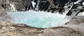
The crater lake in 2004
-
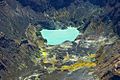
Aerial view of the crater lake in 2005


See also
 In Spanish: Isla Whakaari/White para niños
