
South Waikato District facts for kids
Quick facts for kids
South Waikato District
|
|
|---|---|
|
Territorial authority district
|
|

Tokoroa
|
|
 |
|
| Country | New Zealand |
| Region | Waikato |
| Wards | Tirau Putaruru Tokoroa |
| Seat | Tokoroa |
| Area | |
| • Land | 1,818.88 km2 (702.27 sq mi) |
| Population
(June 2023)
|
|
| • Total | 26,000 |
| Time zone | UTC+12 (NZST) |
| • Summer (DST) | UTC+13 (NZDT) |
| Postcode(s) |
Map of postcodes
|
| Website | South Waikato District Council |
The South Waikato District is a special area in the Waikato Region of New Zealand's North Island. It's like a local government area, meaning it has its own council to help run things. This district is located between some well-known cities. To the north, you'll find Hamilton. To the east is Rotorua, and to the south is Taupō. On its western side is the Ruapehu District.
The main office for the South Waikato District Council is in Tokoroa. This is the biggest town in the district. Other important towns include Putāruru, Tīrau, and Arapuni.
Contents
Towns and Communities
The South Waikato District is home to several towns and smaller communities. These places are grouped into different areas called Wards.
Putaruru Ward
This ward includes the town of Putāruru and other places like Arapuni, Lichfield, and Waotu.
Tirau Ward
In this ward, you'll find the town of Tīrau. Other communities here are Okoroire and Tapapa.
Tokoroa Ward
The largest town, Tokoroa, is in this ward. It also includes areas like Kinleith and Wiltsdown.
People of South Waikato
The South Waikato District is home to many people. In 2023, about 25,044 people lived here. The population has been growing steadily since 2013.
Māori Heritage
The Ngāti Raukawa are the main Māori tribe in this area. Their history here goes back many generations. There are 32 marae (special meeting places) in the district. Some of these include Papa te Aroha marae, Aotearoa marae, and Pikitu marae.

Who Lives Here?
People from many different backgrounds live in South Waikato. The 2023 census showed that about 69% of people were European/Pākehā. Around 38% identified as Māori. There are also many Pasifika people (13.5%) and Asian people (5%). Some people identify with more than one background.
Most people in the district were born in New Zealand. About 13.5% of the population was born overseas.
Beliefs and Work
When it comes to beliefs, about half of the people said they had no religion. Many others are Christian. Some people follow Māori religious beliefs or other religions like Hinduism and Buddhism.
Many people in South Waikato work full-time or part-time. The main jobs are in industries like forestry and farming.
Economy and Jobs
The main jobs and businesses in the South Waikato District are linked to its natural resources.
Forestry and Farming
Historically, forestry (growing trees for wood) and making timber have been very important. However, some of the land that used to be forests is now being used for dairy farming. This means more cows and milk production.
Hydroelectric Power
The district also has several hydroelectric projects. These are power stations that use the force of water to create electricity. They are located on the western side of the district.
Bent St. Skate Park
One cool spot in the South Waikato District is the Bent St. Skate Park. It has a historical skate-bowl that was built way back in the 1980s. It was one of the first skate parks in New Zealand!
Recently, the community decided to give the park a big upgrade. The South Waikato District Council is helping with $550,000 for this project. The plans include adding new skating features, a court area, and places to sit. It's going to be a great place for skaters and the community!
Images for kids
-
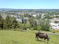
Tokoroa
-
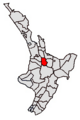
Map of South Waikato District
-
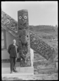
A close-up view of a carved part of a meeting house in Ngatira.
