Ruapehu District facts for kids
Quick facts for kids
Ruapehu District
|
|
|---|---|
|
Territorial authority district
|
|
 |
|

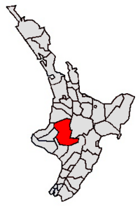
Location of the Ruapehu District
|
|
| Country | New Zealand |
| Island | North Island |
| Region | Manawatū-Whanganui |
| Wards |
|
| Named for | Mount Ruapehu |
| Seat | Taumarunui |
| Towns | |
| Area | |
| • Land | 6,734.41 km2 (2,600.17 sq mi) |
| Highest elevation | 2,797 m (9,177 ft) |
| Population
(June 2023)
|
|
| • Total | 13,050 |
| Time zone | UTC+12 (NZST) |
| • Summer (DST) | UTC+13 (NZDT) |
| Area code(s) | 07 (northern and central) 06 (southern) |
The Ruapehu District is a special area in the middle of New Zealand's North Island. It is managed by a local government called a territorial authority.
This district covers a large area of 6,734 square kilometers. In June 2023, about 13,050 people lived here.
Contents
Exploring Ruapehu District
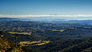
The Ruapehu District is a landlocked area, meaning it has no coastlines. It is famous for its amazing natural features.
National Parks and Mountains
A big part of the district includes the western side of the Tongariro National Park. This park is home to three large volcanoes: Mount Ruapehu, Mount Ngauruhoe, and Mount Tongariro. Mount Ruapehu is the highest point in the district, reaching 2,797 meters (9,177 feet) high.
The district also contains part of the Whanganui National Park. These parks are great for hiking, skiing, and exploring nature.
Famous Railway and Towns
You can find the world-famous Raurimu Spiral here. This is a special part of the North Island Main Trunk railway line. It allows trains to climb a steep hill using a clever spiral track design.
Several towns are popular with tourists, especially those visiting Mount Ruapehu. These include Raetihi, Whakapapa Village, National Park, and Ohakune. These towns are great bases for outdoor adventures.
Waiouru is another important town in the district. It is located high up, at 815 meters (2,674 feet) above sea level. Waiouru is home to the large Waiouru Army Camp, a training base for the New Zealand Army. A well-known road, the Desert Road (part of State Highway 1), runs through the eastern part of the district, connecting Waiouru to Rangipo.
People of Ruapehu District
The Ruapehu District covers about 6,734 square kilometers. As of June 2023, , the estimated population was 13,050 people. This means there are about 1.9 people living in each square kilometer.
Population Changes
| Historical population | ||
|---|---|---|
| Year | Pop. | ±% p.a. |
| 2006 | 13,572 | — |
| 2013 | 11,844 | −1.93% |
| 2018 | 12,309 | +0.77% |
| 2023 | 13,095 | +1.25% |
The population of Ruapehu District has changed over the years. In the 2023 New Zealand census, 13,095 people lived there. This was an increase of 786 people (6.4%) since the 2018 census. It was also an increase of 1,251 people (10.6%) since the 2013 census.
There were 7,962 homes in the district. The average age of people was 39.0 years. About 21.4% of people were under 15 years old. 16.9% were aged 15 to 29. 43.5% were aged 30 to 64, and 18.2% were 65 or older.
Different Cultures
| Ethnicity | Population |
|---|---|
| New Zealand European |
9,009
|
| Māori |
5,979
|
| Pasifika |
456
|
| Asian |
474
|
| MELAA |
81
|
| Other |
153
|
The people in Ruapehu District come from many different backgrounds. In 2023, about 68.8% identified as European/Pākehā. Around 45.7% identified as Māori. Smaller groups included Pasifika (3.5%) and Asian (3.6%). Some people identify with more than one background.
In the 2018 New Zealand census, there were 12,309 people. There were slightly more males (6,288) than females (6,021). About 10.4% of the people were born outside New Zealand.
Beliefs and Work
Many people in the district (51.1%) said they had no religion. About 33.0% were Christian. Some people followed Māori religious beliefs (5.1%). Other religions like Hindu, Muslim, and Buddhist were also present.
For those aged 15 and older, about 10.7% had a university degree or higher. About 25.7% did not have formal qualifications. The average income was $25,300. Many people worked full-time (49.2%). Some worked part-time (14.9%), and a small number (5.0%) were unemployed.
How the District is Governed
The Ruapehu District is run by the Ruapehu District Council. This council was created in 1989. It brought together several smaller councils from the area.
Ruapehu District Council's Role
The council is made up of 12 elected people called councillors. These include a mayor and a deputy mayor. The council helps make decisions for the district.
There are also two special groups called Community Boards. They help local communities have a say in decisions. There is also a Ward Committee that works like the Community Boards.
Who is the Mayor?
The current mayor of the Ruapehu District is Weston Kirton. The deputy mayor is Vivienne Hoeta. They lead the council and represent the district.
Council Members
The council and community boards include:
- Taumarunui-Ohura Community Board: This board has 5 elected community members and 1 councillor.
- Waimarino-Waiouru Community Board: This board also has 5 elected community members and 1 councillor.
- Owhango-National Park Community Board: This board has 5 elected community members and 1 councillor.
These groups work together to manage the Ruapehu District and serve its people.
 | Aurelia Browder |
 | Nannie Helen Burroughs |
 | Michelle Alexander |


