Rangipo Desert facts for kids
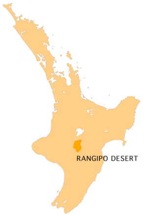
The Rangipo Desert is a unique, dry area in New Zealand. It's not a true desert like the Sahara, but it looks very similar! You can find it on the North Island Volcanic Plateau, in the Ruapehu District. It sits between three active volcanoes—Mount Tongariro, Mount Ngauruhoe, and Mount Ruapehu—and the Kaimanawa Range mountains.
Contents
Why is Rangipo Desert So Dry?
Even though the Rangipo Desert gets a good amount of rain each year (about 1500 to 2500 mm), it still looks like a desert. This is because of several reasons:
- It's on a high, flat area called a volcanic plateau.
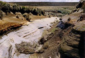
- The soil is very poor. It's made of volcanic ash and pumice.
- Strong, drying winds blow across the area.
- Huge volcanic eruptions about 20,000 years ago, especially fast-moving flows of hot ash called ignimbrite, killed off most of the plant seeds.
The plants that do grow here are short and spread out. You'll mostly see tussock and snow grass. Many small streams start here. They carve deep valleys through the soft volcanic earth.
Weather in the Rangipo Desert
The weather in the Rangipo Desert is very harsh, like in the mountains. It has almost 270 days of ground frost each year. This is much more than the coastal areas, which have fewer than 30 frosty days.
Heavy snow is common here in winter. This is rare for most of New Zealand's North Island. If you go hiking or climbing, be careful of the cold south wind. It can make the temperature feel much colder than it actually is, sometimes below 0°C (32°F) for days.
Most of the desert is high up, over 600 meters (about 2,000 feet) above sea level. A large part of it is even higher, over 1,000 meters (about 3,300 feet) high.
Who Lives in the Rangipo Desert?
Not many people live in this area. This is probably because of the very cold winters and the poor land. The town of Waiouru is to the south. It has a large army training camp. Much of the southern desert is used by the army for training. To the north, there is a prison farm called Rangipo prison farm.
Rivers of the Rangipo Desert
Many of the North Island's biggest rivers begin in this area. They start on the slopes of Mount Ruapehu, which is the highest mountain on the North Island. These rivers include the Waikato and Whangaehu Rivers. Important parts of the Rangitikei and Whanganui Rivers also start here.
The Desert Road
Only one paved road crosses the desert. It's part of State Highway 1 and is known as the Desert Road. In winter, heavy snowstorms and ice often close the road for short times. Emergency services from Turangi watch the northern part of the road. The NZDF Military Police at Waiouru look after the southern part.
Rangipo Desert in Movies
Did you know the Rangipo Desert was used in the famous Lord of the Rings movies? Scenes for the Black Gate of Mordor were filmed here in 2000.
See also
 In Spanish: Desierto de Rangipo para niños
 | Dorothy Vaughan |
 | Charles Henry Turner |
 | Hildrus Poindexter |
 | Henry Cecil McBay |


