
Whangaehu River facts for kids
Quick facts for kids Whangaehu River |
|
|---|---|

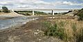
The State Highway bridge at Tangiwai
|
|

|
|
| Native name | Whangaehu |
| Country | New Zealand |
| Region | Manawatū-Whanganui |
| Physical characteristics | |
| Main source | Crater lake Mount Ruapehu 2,550 metres (8,370 ft) 39°17′2″S 175°33′50″E / 39.28389°S 175.56389°E |
| River mouth | Tasman Sea Sea level 40°2′28″S 175°6′0″E / 40.04111°S 175.10000°E |
| Length | 161 kilometres (100 mi) |
| Basin features | |
| Tributaries |
|
The Whangaehu River is a large river located in the middle of the North Island of New Zealand. It starts high up in the mountains, from the crater lake of Mount Ruapehu. This area is part of the central plateau. The river then flows all the way to the Tasman Sea, which is about eight kilometres southeast of the city of Whanganui. Some of the water from the river's beginning is used for a big power project called the Tongariro Power Scheme.
Contents
How Long is the Whangaehu River?
The Whangaehu River flows for about 161 kilometres (100 mi). It travels south until it reaches the South Taranaki Bight. This is a large bay near a small town also called Whangaehu.
What Makes the Whangaehu River Famous?
The Whangaehu River is known for a very sad event that happened on 24 December 1953. Part of the wall of the Mount Ruapehu crater lake suddenly broke. This caused New Zealand's worst train accident, known as the Tangiwai disaster.
The Tangiwai Disaster Explained
A powerful rush of mud and water, called a lahar, rushed down the river. This lahar badly damaged a railway bridge near a small place called Tangiwai. Just minutes later, an overnight express train travelling between Wellington and Auckland tried to cross the bridge. The damaged bridge collapsed, and the train fell into the fast-moving water. Out of 285 people on the train, 151 lost their lives.
Important Dates for the Whangaehu River
- 13 December 1859: A bridge over the river was washed away by floods.
- February 1862: People shared old songs and stories about a mythical creature called a taniwha. They believed this creature had destroyed the Whangaehu bridge.
- 1889: A flood happened because of eruptions from Ruapehu.
- 1895: Another flood occurred due to eruptions from Ruapehu.
- 24 December 1953: The tragic Tangiwai disaster took place.
- 18 March 2007: The crater lake on Mount Ruapehu burst again. It sent an estimated 1.29 billion cubic metres of water, mud, and sludge down the river. Luckily, an alarm system called ERLAWS worked perfectly. This prevented any accidents from happening. This lahar was 50% larger than the one that caused the Tangiwai disaster in 1953.
What is the Geology of the Whangaehu River?
The water in the upper part of the Whangaehu River can sometimes have toxic chemicals. These chemicals come from the volcanic activity happening in and around Mount Ruapehu. The river starts as meltwater from a small glacier. When hot water from the crater lake spills out, it quickly melts the ice and snow in the glacier. This melting can form a tunnel-like cave when seen from below.
See also
 In Spanish: Río Whangaehu para niños
Images for kids
-
The State Highway bridge at Tangiwai
