
North Island Volcanic Plateau facts for kids
The North Island Volcanic Plateau is a large area in the middle of New Zealand's North Island. It's known for its many volcanoes, flat areas made of old lava, and lakes formed in old volcano craters. New Zealand is part of the Pacific Ring of Fire, which is a chain of volcanoes and earthquake sites around the Pacific Ocean.
Contents
Where is the Volcanic Plateau?
This plateau stretches about 100 kilometers (62 miles) from east to west and 130 kilometers (81 miles) from north to south.
Huge sheets of volcanic rock, called ignimbrite, spread out from the Taupo Volcanic Zone. This zone is centered around Lake Taupō, which is a massive lake inside a dormant (sleeping) supervolcano. Lake Taupō is New Zealand's largest lake. Its last big eruption was about 2,000 years ago.
The volcanic area includes three active mountains in the south: Mount Tongariro, Mount Ngauruhoe, and Mount Ruapehu. It reaches up past Rotorua in the north, almost to the Bay of Plenty coast. North of Tongariro is the volcano Mount Pihanga.
The western edge of the plateau has steep cliffs next to the Mamaku Ranges and Kaimai Ranges. To the east, the plateau meets the Ahimanawa, Kaweka, and Kaimanawa mountain ranges. West of the plateau is the volcano Mount Taranaki.
Two of New Zealand's longest rivers, the Whanganui and the Waikato, start their journeys on this plateau.
How the Land Was Formed (Geology)
Mount Ruapehu, the tallest mountain here, is an Andesite cone. It was once twice as high but has been worn down over time. The flat land around the central volcanoes is made from many lahars, which are like thick mudflows. These happen when water from a crater lake or melted snow rushes down the mountain during an eruption. The water picks up ash, small rocks, and even car-sized boulders, forming a dense mud.
An old lahar flow can be seen on the road to the Whakapapa ski field. In December 1953, a sudden lahar on Mount Ruapehu destroyed a rail bridge at Tangiwai. This caused a train to fall into the Whangaehu River, leading to a tragic accident.
The last major eruption in this area was from the Lake Taupō volcano 1,800 years ago. It shot out lava and ash over a huge part of the North Island. About 30 cubic kilometers (7 cubic miles) of material were released. This was the biggest volcanic event in the world in the last 5,000 years.
The entire plateau is more than 300 meters (984 feet) above sea level. A large part of it is even higher, over 800 meters (2,625 feet) up. The plateau has a mild climate. However, temperatures often drop below freezing in winter, and snow can fall from March to October. The most snow falls between July and September. Sudden blizzards can happen on the volcanoes in winter, which can be dangerous for climbers. The Desert Road, a main highway, is often closed by snow for short times in winter.
Plants (Flora)
The natural plants of this area used to be tall podocarp trees. These include rimu (Dacrydium cupressinum), miro (Prumnopitys ferruginea), matai (Prumnopitys taxifolia), totara (Podocarpus totara), and kahikatea (Dacrycarpus dacrydioides). These trees once covered the whole area before the eruptions of Taupō and other volcanoes.
West of the three large volcanoes, the land is rough and covered in forests. North of Lake Taupō, the land is more fertile and rolling, and much of it has been cleared for farming. Forests used to stretch to the west coast. There are still patches of natural plants in wet areas, like the Horowhenua floodplains.
However, east of Taupō, the land is mostly bare. The soil is poor due to ash, and the harsh mountain climate means only scrubby plants can grow there. This area is called the Rangipo Desert. It's not a true desert because it gets a lot of rain. The main reason for the sparse plants was a massive event 20,000 years ago. The Taupō eruption swept white-hot volcanic material through this valley, sterilizing the seeds. Before this, the area was forested. You can still see charcoalized tree stumps where the soil has worn away.
Around Taupō itself, there are geothermal areas with special plants. One example is the low-growing kanuka (a type of kunzea ericoides).
Further east of the plateau are more rough hills in the Kaimanawa Ranges. This is a popular place for hunting wild red and sika deer. The tops of the mountains are open and covered in tussock grass. There are also areas of beech forest and alpine vegetation at higher elevations across the region.
Animals (Fauna)
The northern part of the plateau is home to many animals, especially birds. These include the North Island kōkako wattlebird (Callaeas wilsoni), New Zealand kaka, and large groups of brown kiwi (Apteryx australis). You can also find the blue duck (Hymenolaimus malacorhynchos).
The area south of the plateau, stretching down to Wellington, has various lizards. These include Whitaker's skink (Cyclodina whitakeri), forest gecko (Hoplodactylus granulatus), and Wellington green gecko (Naultinus elegens punctatus). Wetlands throughout the region support waterbirds and fish, including the unique brown mudfish.
Protecting the Plateau (Threats and Preservation)
The lower areas of the plateau are quite populated. Because of this, building new towns, farming, and forestry are big threats to the natural habitats there. One large area of lowland forest remains in and around Whanganui National Park. Many upland areas are protected, either by Māori traditions or in national parks. Te Urewera is the largest of these.
The four national parks in the North Island that surround the plateau are Te Urewera, Whanganui, Egmont, and Tongariro National Park. Tongariro National Park was New Zealand's first national park and is a World Heritage site.
Introduced animals and grazing livestock are now major threats to some native species. Rats, cats, and stoats hunt native reptiles and birds, including the kōkako, blue duck, and brown kiwi. Imported plants like old man’s beard, banana passionfruit, and gorse can take over from native plants. Also, grazing by goats and possums can destroy other plants like kamahi, kaikawaka (Libocedrus bidwillii), and mountain tōtara. To help protect these species, smaller islands off the coast of Wellington are used as safe places for North Island birds and reptiles.
The Volcanic Plateau region also has the largest area of human-made forest in the Southern Hemisphere. Almost all these trees are Pinus radiata. These trees were brought from Kew Gardens in London for testing in Rotorua in 1899. The tree, which originally came from Monterey, California, grew very fast in the poor soils here. Large-scale planting was first done by prisoners in the 1920s and then by unemployed people during the Great Depression.
After World War II, scientists from Norway helped develop ways to treat the soft pine wood to stop it from rotting. They used pressure treatment with chemicals. They also introduced selective breeding methods to improve the trees. This was the main way to improve trees until tissue culture was used in the 1990s. These trees take 25–30 years to grow to full height. Most tree farms use special "growth factor" (GF) trees to make sure the timber is very high quality (straight and knot-free). However, chemical salt treatment is still needed to prevent rotting.
New Zealand has been a leader in using Radiata timber and plywood for building small boats. Untreated clear timber or plywood is used and then covered in epoxy resin after building. The main reason for this is the low cost of the wood. One of New Zealand's largest plywood factories is on the Volcanic Plateau in Tokoroa. While planting by hand is still done on steep land, most seedlings are now planted with machines.
Towns in the region include Taihape in the south, Ohakune (known for growing carrots) in the west, and Taupō in the north. Turangi is a major base for trout fishing at the south end of Lake Taupō. The majority of people in this area live near Lake Taupō. Some smaller settlements are to the east of the volcanoes. People here mainly earn a living from tourism, including skiing in winter, trout fishing (especially on the Tongariro River), or forestry in the northeast (like the Kaingaroa Forest). Some also work on the large Hydro Electric power system.
History of the Plateau
The Māori population was small during the early period. Only two sites from the moa-hunter era have been found. The best-known is the Whakamoenga cave near Taupō. This cave was used about 600 years ago. Items like moa bones, obsidian flakes, and fishing nets have been found there.
The local Māori people, the tangata whenua, are the Ngāti Tūwharetoa. Their main leader is Sir Tumu te Heuheu. They moved into this area after separating from the Arawa tribe on the east coast. Their main meeting place (marae) is on the southern shores of Lake Taupō at Waihi, near the Tokaanu geothermal area. They still own the peaks of the mountains, which are considered sacred. In traditional times, Māori people wore special woven flax eye shields to avoid looking directly at the sacred peaks.
The Rangipo region is mostly empty. It is used by the New Zealand Army, which has a base at Waiouru in the south. There is also a prison farm and an underground power station in Rangipo. In the 1960s, the Tongariro power scheme changed the flow of water from many streams and rivers that drain the central peaks. The water was sent through canals, tunnels, and storage lakes to provide water for two power stations at Rangipo and Tokaanu. This increased the water flowing into Lake Taupō by 20%. Most of the Tongariro River's flow is not part of the power scheme because it's an important breeding area for brown and rainbow trout. The extra water helped boost the amount of water available to the 10 other power stations on the Waikato River, which flows out of Lake Taupō.
The quality of farmland on the plateau greatly improved in the 1950s. Scientists realized that a problem called "bush sickness" in local farm animals was caused by a lack of cobalt in the volcanic soils. A cure was found in 1936, but applying cobalt to the land became possible after World War II. War surplus planes and former pilots were used for aerial topdressing (spreading materials from the air). The cobalt was mixed with crushed phosphate rock from Nauru Island. This mix was called Super Phosphate.
The area is also near Tangiwai, the site of New Zealand's worst railway disaster on Christmas Eve, 1953. A lahar flow from Mount Ruapehu destroyed a rail bridge, leading to a tragic accident.
The largest farm in the North Island, Lochinver Station, is located off the Taupō-Napier road. It was developed in the 1960s and 1970s. This large sheep and cattle farm has several airstrips, 21 houses, and 200 kilometers (124 miles) of roads. It usually has 100,000 breeding ewes (female sheep) and about 8,000 cattle. It also has many shelter belts of pine trees, improved rye-grass pastures, and grows crops like swedes and barley. The farm is open for tourist and school group bus tours.
Fun Things to Do (Popular Culture)
Tourism is a big part of the economy here, with many outdoor activities. You can go trout fishing or flyfishing on the Tongariro River, or try harling on Lake Taupō. There's also tramping (hiking), Mountain biking, deer or pig hunting, horse riding, and snow skiing or snowboarding on Mount Ruapehu.
The Sir Edmund Hillary Outdoor Pursuits Centre of New Zealand is located here. Started by mountaineer Graham Dingle in the 1970s, this center offers valuable outdoor training and skills to high school groups and others.
Train and engineering fans will enjoy the Raurimu Spiral. This part of the main railway line spirals upwards 132 meters (433 feet) through a tunnel and sharp bends. Passengers near the front of the train can see the back carriages going in the opposite direction! When it was built, it was considered an amazing feat of engineering. This was the last section built for the main railway line, completed in 1900.
Cold Kiwi Motorcycle Rally
The Cold Kiwi Motorcycle Rally is advertised as New Zealand's longest-running motorcycle rally. It has been held on the plateau since 1972. The Ruapehu Motorcycle Club runs the event in early September each year. Bikers sleep in their own tents, even though the average night temperature is -8°C (17.6°F). The club provides hot food and drinks, a bonfire, competitions, souvenirs, live bands, and toilets.
The 2016 event was held from Friday, September 2nd, to Sunday, September 4th, at a new site in Horopito on the western side of Mount Ruapehu.
Tongariro Alpine Crossing
The Tongariro Alpine Crossing is a one-day walk from the Mangatepopo Valley across Mount Ngauruhoe and Mount Tongariro. The Department of Conservation calls it one of the greatest one-day walks in the world. The 19.2-kilometer (11.9-mile) track is well marked in summer and is very popular. However, hikers should be quite fit and well-equipped. The route is exposed to the weather, especially during the winter months (April to September), when route markers can be hidden by snow or blown away. There are two well-equipped huts near the ends of the route. Detailed advice is available from the Mount Ruapehu Department of Conservation Visitors Centre.
- 'Geology – overview', Te Ara: The Encyclopedia of New Zealand, updated 13 April 2007. Accessed 2007-07-06.
- Tony Nightingale. 'Government and agriculture - State-funded research', Te Ara: The Encyclopedia of New Zealand, updated 20 November 2008.
Images for kids
-
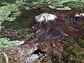
Composite satellite image of Mount Ruapehu
-
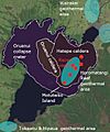
Recent major volcanic features Lake Taupo showing relationship to recent volcanic vents in red and present active geothermal systems in light blue.
-
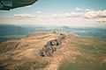
Southwest side of Mount Tarawera, Mount Edgecumbe on the background.
-
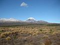
Tongariro National Park


.jpg)
See also
 In Spanish: Meseta Volcánica de la Isla Norte para niños
