Horowhenua District facts for kids
Quick facts for kids
Horowhenua District
|
|
|---|---|
|
Territorial authority district
|
|

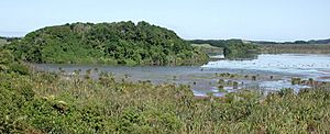
Lake Papaitonga
|
|
 |
|
| Country | New Zealand |
| Region | Manawatū-Whanganui |
| Wards | Levin Waiopehu Miranui Kere Kere |
| Seat | Levin |
| Area | |
| • Total | 1,063.91 km2 (410.78 sq mi) |
| Population
(June 2023)
|
|
| • Total | 37,500 |
| • Density | 35.25/km2 (91.29/sq mi) |
| Time zone | UTC+12 (NZST) |
| • Summer (DST) | UTC+13 (NZDT) |
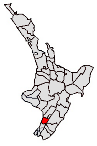
The Horowhenua District is a special area on the west coast of New Zealand's North Island. It is managed by the Horowhenua District Council. This district is located north of Wellington and the Kāpiti area.
It stretches from just north of Ōtaki in the south to just south of Himatangi in the north. It also goes from the coast all the way to the top of the Tararua Range. Horowhenua is part of the Manawatū-Whanganui region. The name Horowhenua comes from the Māori words for "landslide".
Levin is the main town in the district. It is also where the district council has its offices. Other towns in the area include Foxton, Shannon, and Tokomaru. The district is home to about 36,693 people.
Contents
History of Horowhenua
The Horowhenua area has a long history of changes in how it is governed.
Early Beginnings
In 1885, the Horowhenua County was created. This new area was formed from the southern part of the old Manawatu County. It covered a large area, from the Manawatū River in the north to the Waikanae River in the south.
At first, the main offices for the county were in Ōtaki. But in 1896, they were moved to Levin.
Modern District Formation
The current Horowhenua District was officially formed in 1989. This happened during a big change in how local governments were set up across New Zealand.
The new district was created by combining several older areas. These included the Horowhenua County, Foxton Borough, Levin Borough, and a part of the first Manawatū District. However, some southern parts of the old Horowhenua County, like Waikanae and Ōtaki, became part of the Kāpiti Coast District.
Towns and Communities
The Horowhenua District is made up of many towns, smaller communities, and settlements. The larger towns are shown in bold.
|
People and Population
The Horowhenua District covers an area of about 1,064 square kilometers. As of 2023, the estimated population is around 36,693 people. This means there are about 34 people living in each square kilometer.
| Ethnicity | Population |
|---|---|
| New Zealand European |
29,091
|
| Māori |
10,149
|
| Pasifika |
2,667
|
| Asian |
1,797
|
| MELAA |
237
|
| Other |
444
|
The population has been growing steadily. It increased by over 3,400 people since the 2018 census. The median age in the district is 45.5 years. This is a bit older than the national median age of 38.1 years.
Age Groups
- About 18% of the people are under 15 years old.
- Around 16% are aged between 15 and 29.
- About 41% are aged between 30 and 64.
- Roughly 25% are 65 years old or older.
Ethnic Backgrounds
People in Horowhenua come from many different backgrounds.
- Most people (79.3%) are European or Pākehā.
- About 27.7% identify as Māori.
- Around 7.3% are Pasifika.
- About 4.9% are Asian.
- Smaller groups include Middle Eastern, Latin American, African, and other ethnicities.
It's important to know that some people identify with more than one ethnic group.
Religious Beliefs
When asked about religion, many people (51.1%) said they had no religion. About 36% were Christian. Smaller numbers followed Māori religious beliefs, Hinduism, Islam, Buddhism, or other religions.
Land Use and Environment
Much of the Horowhenua area used to be a large wetland. Wetlands are areas where the land is covered by water, like swamps or marshes. This area was once important for a big flax industry. Flax is a plant used to make fabric and other products.
Over time, much of the wetland has been drained. This means the water was removed to turn the land into farms. The soil here is a mix of loam (rich soil) and peat (decayed plant matter). While good for farming, these areas can sometimes flood.
Some parts of the wetland, especially around Lake Horowhenua, are now being restored. This means they are being returned to their natural wetland state. Local Māori groups, like the Muaūpoko Tribal Authority, are helping with this important conservation work.
Museums to Visit
The Horowhenua District has several interesting museums where you can learn about its history and culture:
- Te Awahou Nieuwe Stroom – Located in Foxton.
- Piriharakeke Generation Inspiration Centre – Also in Foxton, focusing on Māori culture.
- Oranjehof Dutch Connection Centre – In Foxton, celebrating Dutch heritage in New Zealand.
- Flax ... Museum – Learn about the history of the flax industry in Foxton.
- MAVTech – Museum of Audiovisual Technology – Explore old audiovisual equipment in Foxton.
Schools in the District
The Horowhenua District has a range of schools for students of all ages.
Secondary Schools
- Manawatū College, in Foxton
- Horowhenua College, in Levin
- Waiopehu College, in Levin
Primary Schools
- Foxton Beach School, Foxton Beach
- Coley Street School, Foxton
- Foxton Primary, Foxton
- St. Marys, Foxton
- Levin East School, Levin
- Fairfield School, Levin
- Ohau School, Ohau (Levin Rural)
- Koputuroa School, Levin Rural
- St. Josephs, Levin
- Levin School, Levin
- Levin North School, Levin
- Taitoko School, Levin
- Poroutawhao School, Levin Rural
- Shannon School, Shannon
- Manakau School, Manakau
- Opiki School, Opiki
- Tokomaru School, Tokomaru
Intermediate Schools
- Levin Intermediate, in Levin
Sports and Recreation
Sports are an important part of community life in Horowhenua.
Rugby
In rugby, a combined Horowhenua-Kapiti team plays in the amateur Heartland Championship. This team represents both the Horowhenua and Kāpiti areas.
Cricket
A Horowhenua-Kapiti cricket team has been competing in the Hawke Cup since 2002. The Hawke Cup is a challenge trophy for New Zealand's district cricket associations.
See also
 In Spanish: Horowhenua para niños
 | Emma Amos |
 | Edward Mitchell Bannister |
 | Larry D. Alexander |
 | Ernie Barnes |

