Manawatū River facts for kids
Quick facts for kids Manawatū River |
|
|---|---|

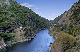
The Manawatu Gorge
|
|

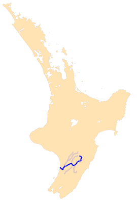
The Manawatū River system
|
|
| Native name | Manawatū |
| Country | New Zealand |
| Region | Manawatū-Whanganui |
| Cities | Palmerston North |
| Physical characteristics | |
| Main source | Ruahine Ranges 40°0′53″S 176°7′1″E / 40.01472°S 176.11694°E |
| River mouth | Tasman Sea Manawatu Estuary, Foxton Beach Sea level 40°28′S 175°13′E / 40.467°S 175.217°E |
| Length | 180 km (110 mi) |
| Basin features | |
| Basin size | 5,899 km2 (2,278 sq mi) |
| Landmarks | Manawatu Gorge, Manawatu Estuary |
| Tributaries |
|
The Manawatū River is a very important river in the lower North Island of New Zealand. It starts in the Ruahine Ranges. The river then flows through the amazing Manawatu Gorge and past the city of Palmerston North. Finally, it crosses the flat Manawatū Plains to reach the Tasman Sea near Foxton.
Contents
The River's Name
The Manawatū River gives its name to the Manawatū-Whanganui region. This is a large area in New Zealand. The river's name comes from a story about a tohunga named Haupipi-a-Nanaia, or Hau for short.
Hau was chasing his wife, Wairaka, who had run away. When he reached this big river, he was so shocked by how wide it was that he stopped and clutched his chest. This is why the river's name comes from the Māori words manawa (meaning 'heart') and tū (meaning 'stand still'). Together, they mean 'heart standing still'. Hau did cross the river. Later, he caught Wairaka and turned her into a rock.
River Journey and Features
The Manawatū River begins its journey northwest of Norsewood. This is on the eastern side of the Ruahine Range. It first flows east, then turns southwest near Ormondville. After about 40 kilometers (25 miles), it turns northwest near Woodville.
The Manawatū Gorge
At Woodville, the river enters the Manawatu Gorge. This is a narrow passage between the Ruahine and Tararua Ranges. After leaving the gorge, the river meets the Pohangina River at Ashhurst. It then turns southwest and flows through Palmerston North. Here, the river still moves quickly and carries small rocks from the mountains.
Flowing to the Sea
After passing Opiki, the river slows down. It starts to curve and bend a lot across the flat Manawatu Plains. The riverbed here is made of mud and sand. As it twists and changes course, it creates interesting features. These include oxbow lakes (U-shaped lakes), lagoons (shallow bodies of water), and swamps (wetlands).
The river also builds up natural banks called levees. These are higher than the land around them. When the river floods, it overflows these banks, creating more wetlands. The Manawatū River finally reaches the Tasman Sea at Foxton Beach. Here, it forms the Manawatu Estuary, which is where the river meets the ocean.
River Size and Tributaries
The Manawatū River is about 180 kilometers (112 miles) long. This makes it the 12th longest river in New Zealand. However, it carries a lot of water, about 102 cubic meters (3,600 cubic feet) per second. This makes it one of New Zealand's biggest rivers by water flow. It is the second largest on the North Island, after the Waikato River.
Many smaller rivers flow into the Manawatū. These are called tributaries. Important ones include the Makakahi, Mangahao, Pohangina, and Oroua Rivers.
Bridges Crossing the River
Many bridges cross the Manawatū River. There are 18 road bridges, 3 rail bridges, and a special walk/cycleway called He Ara Kotahi. The longest bridge is the Whirokino Trestle and Manawatū River Bridge. It carries State Highway 1 for over a kilometer. This new bridge opened in 2020.
How the River Formed
The Manawatū River is special because it flows right through a mountain range. Most rivers start in mountains or hills. But the Manawatū River is older than the Ruahine Range and Tararua Ranges.
About 3 million years ago, these mountains started to rise up. They rose right in the path of the Manawatū River. But the river was so big and powerful that it kept flowing. It carved its way through the rising mountains, creating the Manawatu Gorge. Other rivers nearby couldn't do this, so they joined the Manawatū instead.
River Terraces
After leaving the gorge, the river carries rocks and dirt from the mountains. During very cold times, called glacial periods, there was a lot of ice and snow. This caused more erosion, creating high, stony terraces along the river. During warmer times, called interglacial periods, forests grew on the mountains. This meant less gravel came down, and the river cut deeper into the terraces. This cycle has created four distinct terraces between the Manawatū Gorge and Palmerston North.
The Manawatū Plain
The flat land around the Manawatū River, called the Manawatū Plain, was once under the sea. This was about 5 to 6 million years ago. As the land rose, it buckled, forming five long, low ridges. These ridges run parallel to the mountains. They make the Manawatū, Rangitikei, and Oroua Rivers flow southwest instead of directly into the Tasman Sea.
Plants and Wetlands
When people first arrived in New Zealand, the Manawatū Plains were covered in thick forests. Near the mountains and the Manawatū Gorge, you would find black beech trees. Lower down, there were tawa forests. On the plains and terraces, there was a mix of podocarp and tōtara trees. Closer to the sand dunes, the forest changed to a mix of tawa, tītoki, and māhoe.
Swamps and Estuary
Along the river's flood plain, the main plants were in semi-swamp forests. These were mostly kahikatea and pukatea trees. There were three large swamps next to the Manawatū River. These included the Moutoa Swamp, the Makerua Swamp, and the Taonui Swamp. The main plants in these swamps were harakeke (flax) and raupō (bulrushes). Harakeke grew in drier parts, and raupō in wetter areas.
The Manawatū river mouth and estuary is very important. In 2005, it was recognized internationally as a Wetland of International Importance under the Ramsar Convention. This means it's a special place for wildlife, especially birds.
Flooding Events
The Manawatū River can sometimes flood. In February 2004, a big flood happened. Over 3,000 people had to leave their homes, mainly from Marton and Feilding. More than 1,000 farms in the Manawatū area were damaged. The cost of this flood in insurance payments was about NZ$122 million.
To help prevent damage from floods, there are Moutoa floodgates. These gates can be opened to let excess water flow into a special floodway. This helps protect the towns of Foxton and Shannon from the river's high waters.
Water Quality
People are working to improve the water quality of the Manawatū River. In 2018, a study looked at the water quality in the Manawatū-Whanganui region. This study was done by Land Water People (LWP) and reviewed by experts. It found that water quality for things like sediment (dirt particles) and E. coli (a type of bacteria) had improved over the past seven to ten years. This showed that local efforts to clean up the water were working.
However, there have been concerns in the past. In 2009, a study found that the Manawatū River had very high levels of "gross primary production" (GPP). High GPP means there are too many plants and algae growing, which can be a sign of poor ecological health. This can cause problems for the river's ecosystem.
In 2011, the Palmerston North City Council was criticized for not following rules about discharging wastewater into the river. A report also compared the Manawatū to other New Zealand rivers for water clarity and E. coli levels. It found that only a few other rivers had worse water quality than the Manawatū at that time. Efforts continue to make the river healthier.
See also
 In Spanish: Río Manawatu para niños
 | Isaac Myers |
 | D. Hamilton Jackson |
 | A. Philip Randolph |

