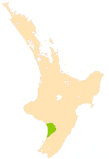
Manawatu Plains facts for kids
The Manawatu Plains are a very important and fertile (meaning good for growing things!) area in the southwestern part of New Zealand's North Island. This special region is made up of the flat lands next to the Manawatu and Rangitikei Rivers.
This large, triangular area of low-lying land stretches from around Levin in the south (in the Horowhenua area) all the way north to Marton. It reaches inland from the South Taranaki Bight almost to Ashhurst, which is near the start of the Manawatu Gorge. The Manawatu Plains cover a big space, about 1,000 square kilometres (or 386 square miles).
Contents
What Makes the Manawatu Plains Special?
The Manawatu Plains are known for their rich soil, which is great for farming. This land was formed over many years by the rivers, which deposited fertile soil during floods.
Farming and the Economy
The plains are a huge part of the economy for many nearby towns and cities. Places like Palmerston North, Foxton, Feilding, and Bulls all rely a lot on the money made from farming. This area is especially important for dairy farming, which means raising cows for milk.
Wetlands and Conservation
In the southern part of the plains, especially around Lake Horowhenua, there used to be a very large area of wetlands. Wetlands are like swamps or marshes, full of water and special plants and animals. Over time, much of this wetland was drained so that farmers could use the land for dairy farming.
However, people are now working hard to protect and restore some of these wetlands. This is called conservation, and it helps bring back the natural environment and the creatures that live there.
Living with Water
Because the Manawatu Plains are floodplains, they are sometimes covered by water. Even though the area usually gets a bit less rain than the average for New Zealand, floods can still happen. For example, the town of Tangimoana experienced flooding in early 2004. Living on a floodplain means that the land is naturally shaped by rivers and water.
 | Ernest Everett Just |
 | Mary Jackson |
 | Emmett Chappelle |
 | Marie Maynard Daly |


