
Manawatu Gorge facts for kids

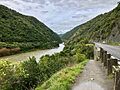
The Manawatū Gorge (called Te Āpiti in Māori) is a deep, narrow valley carved by the Manawatū River in the North Island of New Zealand. It's about 6 kilometers long. This amazing gorge separates the Ruahine and Tararua Ranges. It connects the Manawatū and Hawke's Bay areas.
You can find the gorge northeast of Palmerston North. Its western end is near Ashhurst, and its eastern end is close to Woodville. The Manawatū Gorge is a really important pathway. It's one of the few places that links the eastern and western parts of the North Island.
A railway line, the Palmerston North–Gisborne Line, goes through the gorge. State Highway 3 also used to run here, but the road has been closed since 2017. The gorge is also a great place for fun activities. It's part of the Manawatū Gorge Scenic Reserve. You can find many walking tracks through the native forest there.
The story of the Manawatū Gorge is a big part of traditional Māori history. Māori legends say that Whātonga, an explorer from the Kurahaupō canoe, discovered the gorge around the 12th century. Europeans started exploring the gorge in the 1840s. In 1842, Bishop George Augustus Selwyn and Chief Justice William Martin traveled through it.
Contents
Understanding the Name: Manawatū Gorge
The Manawatū Gorge gets its name from the river that flows through it, the Manawatū River. The name "Manawatū" has a special meaning in Māori. It comes from the words manawa, which means 'heart', and tū, meaning 'coming to a halt'.
This name comes from an old Māori story. It's said that a traveler named Haunui-a-nanaia spoke these words. He said them when he first saw the river while searching for his wife, Wairaka.
The Māori name for the gorge itself is Te Āpiti. This name usually means 'the narrowing' or 'the narrow passage'. Sometimes, the gorge was also called Te Au-rere-a-te-tonga.
How the Manawatū Gorge Was Formed
The Manawatū Gorge is very special because of how it was made. Most gorges are formed when a river cuts through mountains that are already there. But the Manawatū River is different. It's a "water gap." This means the river cut through the mountains as they were still rising up!
Imagine the mountains slowly pushing upwards. At the same time, the river kept eroding, or wearing away, the rock. This created the gorge right through the middle of the rising ranges. This is why the Manawatū River is unique in New Zealand. It's the only river that starts on one side of the main mountain divide and ends on the other side.
Travel Through the Gorge: Roads and Railways
The Manawatū Gorge has always been an important route for travel.
The Road Through the Gorge
A road, State Highway 3, was built on the south side of the river. It was finished in 1872. For a long time, this road was the main link between the eastern and western parts of the lower North Island.
However, the road had problems with slips (landslides). These slips often happened after bad weather. Because of many large slips, the road was permanently closed in 2017. Before its closure, the gorge road was one of the only east-west connections in a large area. Other local roads nearby, like Saddle Road and Pahiatua Track, are much narrower and winding.
After the closure, the New Zealand Transport Agency looked for new ways to connect the regions. A new route is now being built above the gorge. It will help travelers bypass the old road and the town of Ashhurst.
The Railway Line
A single railway track was built on the northern side of the gorge. It was completed in 1891. This railway line is now part of the Palmerston North–Gisborne Line.
Today, the railway is mostly used by freight trains carrying goods. There are no regular passenger trains through the gorge. However, sometimes special railway trips, often with old steam trains, use this scenic line. It has two tunnels and several small bridges, making it a fun journey.
Old Gorge Cemetery
On the north side of the Manawatū Gorge, you can find the Old Gorge Cemetery. It's a historic burial ground. You can visit it, but no new burials have taken place there for many years. The cemetery is just a few kilometers from Woodville.
Exploring the Manawatū Gorge Track
If you love walking and nature, the Manawatū Gorge Track is a great place to visit. This walking track is about 10 kilometers long. It runs along the south side of the gorge, winding through beautiful native bush.
Lookout Points and Views
As you walk the track, you'll find several lookout points. One of these is called the "Big Slip Lookout." It's located above the area where a large landslide happened in 2015. Most of the track goes through the native forest. The lookouts offer amazing views of the gorge itself. You can also see the Te Apiti Wind Farm on the hills north of the gorge.
The Whatonga Sculpture
Along the track, deep in the native bush, you'll discover a tall metal sculpture. This sculpture is 6 meters high and shows Whatonga. Whatonga was one of three important Māori chiefs. He was on the Kurahaupo Waka, a large canoe that traveled across the ocean to New Zealand.
The sculpture was paid for by a group working to protect the Manawatū Gorge's wildlife. It's made of steel. A helicopter had to lower it into its spot in the bush! It was blessed in a special ceremony on April 11, 2014. The artwork on the sculpture features patterns like hammerhead sharks. It tells parts of Whatonga's sea journey story. It also includes symbols from all the groups involved in the Manawatū Gorge biodiversity project.
You can find the latest information about all the walking and biking tracks on the Te Apiti website.
Images for kids
-
This sign shows the road is closed to everyone, even walkers. The Manawatu Gorge Track goes under the bridge.
-
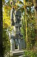
The Whatonga sculpture on the Manawatu Gorge Track, glowing in the evening sun.


