Mangahao River facts for kids
Quick facts for kids Mangahao River |
|
|---|---|

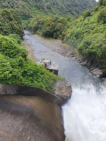
Mangahao River flowing downstream from Mangahao Upper No. 1 Reservoir
|
|
| Country | New Zealand |
| Physical characteristics | |
| Main source | Tararua Range |
| River mouth | Manawatu River |
| Length | 86 km |
The Mangahao River is a cool river found in the North Island of New Zealand. It starts high up in the Tararua Ranges. The river then flows towards the northeast. Eventually, it joins the larger Manawatu River, which is located south of a town called Woodville.
There are two large dams built on the Mangahao River. These dams help to move water through tunnels. The water then goes to a third reservoir on the Tokomaru River. From there, it travels to the Mangahao Power Station. This power station is near a town called Shannon and uses the water to make electricity.
The River's Journey
The Mangahao River begins its journey in the Tararua Range. This mountain range is a rugged and beautiful part of New Zealand. As the river flows, it carves its way through the landscape. It travels for about 86 kilometers before reaching its end.
The river's path takes it through different areas. It passes by forests and open land. Finally, it meets the Manawatu River. This meeting point is an important part of the local environment.
Making Electricity with Water
The dams on the Mangahao River are very important. They help to create clean energy for New Zealand. When water is held back by a dam, it creates a lot of pressure. This pressure can be used to spin large turbines.
These turbines are connected to generators. The generators then produce electricity. This type of power is called hydroelectricity. It is a renewable energy source. This means it can be used again and again. It does not run out like fossil fuels.
The Mangahao Power Station is a key part of this system. It takes the water from the river. Then it turns the water's energy into electricity. This electricity helps power homes and businesses.
River's Path Through Rocks
Over thousands of years, the Mangahao River has shaped the land. The upper part of the river, about 30 kilometers long, has changed its course. It used to flow into a different stream. Now, it flows into the Mangatainoka River.
The river has cut a very deep gorge. A gorge is like a narrow valley with steep sides. In some places, this gorge is over 100 meters deep. The river flows through ancient rocks. These rocks are called greywacke and argillite. They were formed a very long time ago.
 | Kyle Baker |
 | Joseph Yoakum |
 | Laura Wheeler Waring |
 | Henry Ossawa Tanner |

