Waiouru facts for kids
Quick facts for kids
Waiouru
|
|
|---|---|

The National Army Museum in Waiouru
|
|
| Country | New Zealand |
| Region | Manawatū-Whanganui |
| District | Ruapehu District |
| Ward |
|
| Community | Waimarino-Waiouru Community |
| Electorates |
|
| Area | |
| • Total | 5.01 km2 (1.93 sq mi) |
| Elevation | 792 m (2,598 ft) |
| Population
(June 2022)
|
|
| • Total | 770 |
| • Density | 153.7/km2 (398.1/sq mi) |
| Time zone | UTC+12 (NZST) |
| • Summer (DST) | UTC+13 (NZDT) |
| Postcode |
4825, 4826
|
| Area code(s) | 06 |
Waiouru is a small town in the Ruapehu District of New Zealand's Manawatū-Whanganui region. It sits on the south-eastern North Island Volcanic Plateau. The town is about 130 kilometres north of Palmerston North. It is also 25 kilometres south-east of Mount Ruapehu. In 2018, Waiouru had a population of 765 people.
The most famous place in Waiouru is the National Army Museum. It opened in 1978 and shows New Zealand's military history. The town also has a police station, garages, and places to eat. There are special fuel stops for the many large trucks that pass through daily. A grocery store and medical centre are located in the army housing area.
Waiouru is known as a military town. It grew because of the New Zealand Army Camp. This camp is where new soldiers get their training. The Desert Road, just north of Waiouru, goes through a huge army training area. The Royal NZ Navy also has a communications station nearby called HMNZS Irirangi.
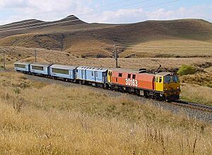
The section of State Highway 1 north of Waiouru is called the Desert Road. It stretches for 50 kilometres through the Rangipo Desert to Tūrangi. Waiouru is also on the North Island Main Trunk railway line. Waiouru Railway Station is the highest train station in New Zealand, at 814 metres above sea level.
Seven kilometres west of Waiouru is Tangiwai. This place was the site of New Zealand's worst railway disaster. On Christmas Eve in 1953, a train crashed after a bridge was damaged. A mudflow (lahar) from Mount Ruapehu had weakened the bridge. The train fell into the Whangaehu River, and 151 people died. Many army and navy people helped rescue survivors. A nurse from Waiouru Camp Hospital, known as "The Angel of Tangiwai," worked tirelessly to help.
Contents
Waiouru's Past: A Look at Its History
Early Farming and Land Disputes
In 1855, Merino sheep were brought to Waiouru by a missionary named Tom Grace. They grazed on the tussock grass plains. Later, more sheep were brought from Hawke's Bay. The Murimotu plains around Waiouru were huge, perfect for grazing thousands of sheep. Wool was very valuable back then.
In 1871, the government wanted to lease these plains from the Māori landowners. But many different Māori groups owned parts of the land. They had used it for hunting and gathering for a long time. This led to many disagreements and delays in the Land Court.
While these arguments continued, a man named John Studholme started grazing his sheep illegally. He had made a deal with one of the Māori leaders. In 1874, his men brought cattle and sheep to the land. They also started building huts and sheds.
In 1880, Studholme tried to get full ownership of the land. This made the Ngati Rangi people very angry. They called on Major Kemp, a famous fighter, for help. Other local groups also prepared for conflict. Luckily, a missionary helped calm the situation. In 1884, the Land Court finally decided who owned each part of the land. Studholme was allowed to keep his lease for a few more years. However, the price of wool dropped, and a very cold winter in 1893 killed many of his sheep.
Developing Waiouru's Infrastructure
In the 1870s, tracks were made in the area. These tracks were used to transport wool to places like Napier and Wanganui. Over time, these tracks became roads for wagons and stage-coaches. By 1897, there was a coaching house in Waiouru for travelers.
Around 1904, Alfred Peters set up a post office, store, and a place for travelers to stay. This was also useful for the 500 men working on the new railway line nearby. His family still farms in the area today.
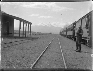
The North Island Main Trunk railway reached Waiouru in 1907. The Waiouru railway station opened then. It stopped handling goods in 1986 and passengers in 2005.
By 1907, sheep farming in Waiouru was struggling. Too many sheep had eaten the grass, leading to a huge problem with rabbits. By the 1930s, sheep could no longer be grazed there. In 1939, the government took most of the Waiouru sheep station land for the Army Camp.
Wally Harding started farming in Waiouru in 1939. He used large machines to prepare the land for crops. In 1951, he began spreading fertilizer from a plane. This led to his company, Wanganui Aero Work Ltd. His grandson still farms in Waiouru today.
In 1978, the National Army Museum opened. It was built by New Zealand Army engineers next to State Highway 1. The museum has been expanded several times since then.
Waiouru's People: Demographics
Waiouru covers about 5.01 square kilometres. In 2018, its population was 765 people. This was a small increase from 2013 but a big decrease from 2006.
- In 2018, there were 219 households.
- There were more males (438) than females (327).
- The average age was 28.0 years, which is younger than the national average.
- About 25.9% of the people were under 15 years old.
Most people in Waiouru are of European/Pākehā background (67.8%). A significant number are also Māori (41.2%). Other groups include Pacific peoples and Asian.
About 51.4% of people said they had no religion. Many others were Christian (31.4%) or had Māori religious beliefs (5.1%).
The median income in Waiouru was $44,900, which was higher than the national average. Most people (74.6%) aged 15 or older were employed full-time.
Waiouru Military Camp: A Training Hub
The Waiouru Military Camp began as a training area for artillery in the 1930s. In 1939, after war was declared, the government took more land. By 1940, a large training camp was built. More land was added later for training and other projects.
The camp grew a lot in the 1950s for compulsory National Service. At its busiest in the 1970s, Waiouru had about 6,000 people living there. This included over 600 school-aged children.
In the 1980s and 1990s, some army units moved to other camps. Waiouru's population dropped to about 3,000 by 1990. It continued to drop to around 2,000 by 2005. However, the Army still uses Waiouru for many training courses.
Waiouru Airfield: For Air Force Training
The Royal New Zealand Air Force uses Waiouru Airfield for practice. This airfield is west of the main camp. Large C-130 Hercules planes practice landing there. Inside the camp, Jameson Field is used by NH-90 and A-109 helicopters.
HMNZS Irirangi is a radio station located 2 kilometres south of Waiouru. The Royal New Zealand Navy used it during World War II. It was known as Waiouru W/T Station. From 1951, it was called HMNZS Irirangi. It was used to intercept radio signals. Today, it is no longer used for that purpose.
Waiouru's Weather: A Cold Climate
Waiouru is high up and close to Mt Ruapehu. This means it has a cold climate all year round. It gets especially cold when the wind blows from the mountain. The Desert Road often closes in winter because of heavy snow. Waiouru's climate is like a continental one.
 | DeHart Hubbard |
 | Wilma Rudolph |
 | Jesse Owens |
 | Jackie Joyner-Kersee |
 | Major Taylor |


