Taihape facts for kids
Quick facts for kids
Taihape
|
|
|---|---|
|
Minor urban area
|
|
 |
|
| Country | New Zealand |
| Region | Manawatū-Whanganui |
| District | Rangitikei District |
| Wards |
|
| Community | Taihape Community |
| Early settlement | pre-European |
| Taihape | 1894 |
| Named for | Shortened form of Ōtaihape. |
| Electorates |
|
| Area | |
| • Total | 4.93 km2 (1.90 sq mi) |
| Population
(June 2023)
|
|
| • Total | 1,800 |
| • Density | 365/km2 (946/sq mi) |
| Postcode |
4720
|
| Area code(s) | 06 |
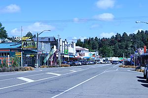
Taihape is a small town located in the Rangitikei District on the North Island of New Zealand. It is an important service center for the many farms in the area. State Highway 1, a major road that runs through the middle of the North Island, goes right through Taihape.
Contents
Taihape's History and Culture
How Taihape Began
The Taihape area was first home to Māori people. These groups, called iwi (tribes), still live there today. The first European to visit this region was William Colenso in 1845. Later, in 1884, a team surveying for the Main Trunk railway line created a rough path through the district.
The town of Taihape was officially started in 1894. European settlers arrived from Canterbury in the South Island. The town was built in a small natural clearing within a thick native forest. The first settlers worked hard to clear this land. Many families living in the area today are descendants of these original settlers.
The settlement was first named Hautapu, after a local river. Then it was called Ōtaihape, which means "the place of Tai the Hunchback." Finally, its name was shortened to Taihape. Before the railway was built, farmers had to transport their wool by horse and cart to Napier. From there, it was sent overseas. Taihape was quite isolated until roads and railways were built in the early 1900s.
Taihape's Recent Story
Taihape grew into a key town for railways and transport. It was busiest in the 1950s and 1960s. The town faced challenges in the 1980s when the railway system changed. Today, Taihape is a popular stop for travelers and a service hub for local farms.
Taihape is famous for its yearly Gumboot Day festival. It first happened on April 9, 1985. Local businesses created this festival to celebrate the town's rural image. A giant sculpture of a gumboot stands proudly at the edge of town. This sculpture was made by New Zealand artist Jeff Thomson using corrugated iron. A famous entertainer, John Clarke, used Taihape as a setting for his funny character, Fred Dagg.
Marae: Meeting Places in Taihape
There are five marae in the Taihape area. These are special meeting places where local iwi (tribes) and hapū (sub-tribes) gather.
- Kuratahi Marae and Te Karere meeting house belong to the Ngāti Rangi hapū of Ngāti Rangituhia and Ngāti Parenga.
- Opaea Marae and Tumakaurangi meeting house belong to the Ngāti Tūwharetoa hapū of Ngāti Tamakōpiri.
- Raketapauma Marae and Rangituhia meeting house belong to the Ngāti Rangi hapū of Ngāti Rangituhia.
- Tamakopiri Marae and Tumakaurangi meeting house belong to the Ngāti Kahungunu hapū of Ngāti Tama.
- Winiata Marae, with its meeting house Tautahi, is the home of Ngāti Hinemanu and its hapū, Ngāti Paki.
In October 2020, the government provided money to improve seven marae, including Opaea Marae and Raketapauma Marae. This project helped create many jobs in the area.
Taihape's Economy and Jobs
Taihape is a town that supports the surrounding rural areas. In the 1960s, it was a major center for railways and transport. Most of its economic activity was linked to the railway and farming. The town's economy slowed down in the 1980s. This was due to changes in the railway system and a decline in farming.
Recently, with more tourists visiting, Taihape's businesses are doing better. Its location on the North Island Main Trunk railway and State Highway 1 has helped it survive. Taihape calls itself the "Gumboot Capital of the World." Many people come to its yearly gumboot-throwing competition.
Taihape's Geography and Location
Taihape is located near where the Hautapu and Rangitikei rivers meet. It sits about 500 meters (1,640 feet) above sea level. The town is in a sheltered valley among the high country of the central North Island. It is close to the Rangitikei River and the Ruahine Ranges.
The area around Taihape has fertile land, great for sheep and deer farming. Its closeness to mountains, rivers, and lakes makes it a key spot for hunting and outdoor tourism. The town is also at the southern edge of the volcanic plateau. Roads in and out of Taihape have improved over time. What were once difficult roads are now easier routes through the hills.
Taihape's Climate
Taihape has a mild climate. Summers are gentle, and winters are frosty. On average, the temperature goes above 25°C (77°F) about 31 days a year. It drops below 0°C (32°F) on about 45 nights each year. Taihape receives a good amount of rain throughout the year.
The climate is classified as an oceanic climate (Cfb). The average temperature for the year is 11.5°C (52.7°F). About 953 mm (37.5 inches) of rain falls annually.
| Climate data for Taihape, elevation 433 m (1,421 ft), (1991–2020 normals, extremes 1911–present) | |||||||||||||
|---|---|---|---|---|---|---|---|---|---|---|---|---|---|
| Month | Jan | Feb | Mar | Apr | May | Jun | Jul | Aug | Sep | Oct | Nov | Dec | Year |
| Record high °C (°F) | 33.5 (92.3) |
33.0 (91.4) |
30.3 (86.5) |
26.0 (78.8) |
23.0 (73.4) |
24.1 (75.4) |
19.6 (67.3) |
21.5 (70.7) |
24.0 (75.2) |
25.0 (77.0) |
30.0 (86.0) |
30.0 (86.0) |
33.5 (92.3) |
| Mean maximum °C (°F) | 28.6 (83.5) |
28.6 (83.5) |
26.6 (79.9) |
23.1 (73.6) |
19.8 (67.6) |
17.1 (62.8) |
16.1 (61.0) |
16.5 (61.7) |
19.1 (66.4) |
21.6 (70.9) |
24.4 (75.9) |
26.5 (79.7) |
29.7 (85.5) |
| Mean daily maximum °C (°F) | 23.4 (74.1) |
23.7 (74.7) |
21.2 (70.2) |
17.6 (63.7) |
14.6 (58.3) |
11.9 (53.4) |
11.3 (52.3) |
12.2 (54.0) |
14.2 (57.6) |
16.2 (61.2) |
18.6 (65.5) |
21.3 (70.3) |
17.2 (62.9) |
| Daily mean °C (°F) | 16.9 (62.4) |
17.0 (62.6) |
14.7 (58.5) |
11.6 (52.9) |
9.1 (48.4) |
7.0 (44.6) |
6.4 (43.5) |
7.1 (44.8) |
9.1 (48.4) |
11.0 (51.8) |
12.9 (55.2) |
15.5 (59.9) |
11.5 (52.8) |
| Mean daily minimum °C (°F) | 10.4 (50.7) |
10.3 (50.5) |
8.1 (46.6) |
5.7 (42.3) |
3.6 (38.5) |
2.1 (35.8) |
1.4 (34.5) |
2.1 (35.8) |
4.0 (39.2) |
5.7 (42.3) |
7.1 (44.8) |
9.7 (49.5) |
5.9 (42.5) |
| Mean minimum °C (°F) | 3.3 (37.9) |
3.4 (38.1) |
1.3 (34.3) |
−1.1 (30.0) |
−2.6 (27.3) |
−4.1 (24.6) |
−4.8 (23.4) |
−3.5 (25.7) |
−2.6 (27.3) |
−0.8 (30.6) |
0.2 (32.4) |
2.9 (37.2) |
−5.3 (22.5) |
| Record low °C (°F) | −0.1 (31.8) |
−1.3 (29.7) |
−2.8 (27.0) |
−3.6 (25.5) |
−6.7 (19.9) |
−7.5 (18.5) |
−9.1 (15.6) |
−6.1 (21.0) |
−5 (23) |
−5.1 (22.8) |
−2.2 (28.0) |
−1.3 (29.7) |
−9.1 (15.6) |
| Average rainfall mm (inches) | 68.4 (2.69) |
54.5 (2.15) |
55.3 (2.18) |
92.2 (3.63) |
75.9 (2.99) |
88.0 (3.46) |
92.0 (3.62) |
85.5 (3.37) |
84.7 (3.33) |
92.5 (3.64) |
77.3 (3.04) |
81.4 (3.20) |
947.7 (37.3) |
| Source: NIWA | |||||||||||||
People Living in Taihape
Taihape covers an area of 4.93 square kilometers (1.90 sq mi). As of 2018, it had an estimated population of 1,716 people. This means there were about 348 people per square kilometer. The population was highest in the late 1960s, with around 3,500 residents. Like many other rural towns, its population has decreased since then.
| Historical population | ||
|---|---|---|
| Year | Pop. | ±% p.a. |
| 2006 | 1,839 | — |
| 2013 | 1,575 | −2.19% |
| 2018 | 1,716 | +1.73% |
The people of Taihape come from diverse backgrounds:
- 69.1% are European/Pākehā.
- 47.9% are Māori.
- 4.4% are Pacific peoples.
- 3.7% are Asian.
- 1.2% are from other ethnic groups.
Some people identify with more than one ethnicity. About 10.1% of people in Taihape were born overseas. This is lower than the national average of 27.1%.
When asked about their religious beliefs, 45.1% of people said they had no religion. 37.9% were Christian. 5.4% followed Māori religious beliefs. Small percentages were Hindu (0.3%), Muslim (0.5%), Buddhist (0.2%), or other religions (0.9%).
For those aged 15 and older, 8.7% had a bachelor's degree or higher. 27.4% did not have any formal qualifications. The average income was $27,100, which is less than the national average of $31,800. About 10.7% of people earned over $70,000. In terms of jobs, 50.8% worked full-time, 18.0% worked part-time, and 1.8% were unemployed.
Taihape's Railway History
Taihape Railway Station was a very important stop on the North Island Main Trunk railway line. It had a large area for sorting trains and a place to keep locomotives until the late 1970s.
Many railway houses used to be along Mataroa Road, but now only three remain. Taihape once had two lodges of the Royal Antediluvian Order of Buffaloes, a social organization. One of these, Kaikoura Lodge No 226, was named after the local Kaikoura River. This lodge existed until 2007. It even had its own meeting rooms. A purple house on the highway, as you drive south into Taihape, was once one of these halls. The lodge in Taihape had many members, partly because of the large number of railway and Post Office staff in the town.
In 1999, the company Tranz Rail took down the old Taihape Railway Station. However, the Refreshment Rooms are still on the old station platform. The old goods shed and locomotive depot are also still there at the south end of the rail yard. After a lot of fundraising by Rotary, a special turntable for locomotives was bought and put back in the station yard. This allows special trains to come to Taihape and turn around for their journey back.
Education in Taihape
Taihape has two main schools for students.
Taihape Area School
Taihape Area School is a school for all students from Year 1 to Year 13. It is a state school, meaning it is funded by the government. As of 2024, it has about 549 students. This school was created in 2005. It combined Taihape's primary and secondary schools because fewer students were attending each school separately.
St Joseph's School
St Joseph's School is also in Taihape. It is a Catholic primary school for students from Year 1 to Year 8. This school is state-integrated, meaning it is partly funded by the government but keeps its special Catholic character. As of 2024, it has about 24 students. St Joseph's School was first opened in 1916.
Notable People from Taihape
Many interesting people have come from Taihape, including:
- Douglas MacDiarmid, a famous artist.
- Nehe Milner-Skudder, a well-known rugby union player.
- Nash Chase, an entertainer.
- Moke Belliss, a rugby union player.
 | Selma Burke |
 | Pauline Powell Burns |
 | Frederick J. Brown |
 | Robert Blackburn |


