Rangitikei District facts for kids
Quick facts for kids
Rangitikei District
|
|
|---|---|
|
Territorial authority district
|
|

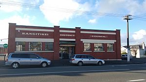
Rangitikei District Council offices in Marton
|
|
 |
|
| Country | New Zealand |
| Region | Manawatū-Whanganui |
| Wards | Northern Central Southern |
| Formed | 1989 |
| Seat | Marton |
| Area | |
| • Land | 4,483.91 km2 (1,731.25 sq mi) |
| Population
(June 2023)
|
|
| • Total | 16,300 |
| Time zone | UTC+12 (NZST) |
| • Summer (DST) | UTC+13 (NZDT) |
| Postcode(s) |
Map of postcodes
|
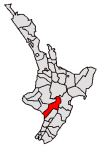
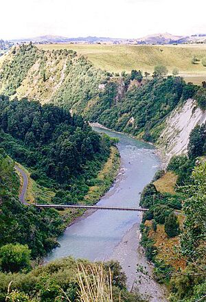
The Rangitikei District is a special area in the North Island of New Zealand. It is mostly in the Manawatū-Whanganui region. A small part of it, the town of Ngamahanga, is in the Hawke's Bay Region. This district is in the southwest of the North Island. It follows the path of the Rangitīkei River.
The Rangitikei District Council is the local government for this area. It is made up of a mayor and 11 councillors. The current mayor is Andy Watson.
Contents
History of Rangitikei
The Rangitikei District was created in 1989. This happened during big changes to local government in New Zealand.
Geography and Climate

This district is located north of Wellington. It stretches from the South Taranaki Bight towards the North Island Volcanic Plateau. It is shaped like a trapezium. The district includes towns like Taihape, Bulls, Marton, Hunterville, and Mangaweka. The total land area is about 4,484 square kilometers.
Weather in Rangitikei
Rangitikei has a mild climate. It does not have extreme weather like some other parts of New Zealand. This type of weather is called an oceanic climate. Summers are warm, with average temperatures around 20 degrees Celsius. The best weather is usually in summer and early autumn.
Winters are mild near the coast and on the flat lands. It gets colder in the hills and inland areas. However, winter days are often clear and calm, with frost. Sometimes, snow falls in areas higher than 400 meters, like Taihape. The district gets a moderate amount of rain each year. It also gets over 2,000 hours of sunshine per year.
| Climate data for Marton | |||||||||||||
|---|---|---|---|---|---|---|---|---|---|---|---|---|---|
| Month | Jan | Feb | Mar | Apr | May | Jun | Jul | Aug | Sep | Oct | Nov | Dec | Year |
| Mean daily maximum °C (°F) | 22.1 (71.8) |
22.5 (72.5) |
20.7 (69.3) |
18.1 (64.6) |
15.1 (59.2) |
12.8 (55.0) |
12.1 (53.8) |
12.9 (55.2) |
14.5 (58.1) |
16.4 (61.5) |
18.3 (64.9) |
20.3 (68.5) |
17.2 (63.0) |
| Daily mean °C (°F) | 17.4 (63.3) |
17.7 (63.9) |
16.1 (61.0) |
13.7 (56.7) |
11.0 (51.8) |
8.9 (48.0) |
8.2 (46.8) |
8.9 (48.0) |
10.5 (50.9) |
12.3 (54.1) |
14.0 (57.2) |
15.9 (60.6) |
12.9 (55.2) |
| Mean daily minimum °C (°F) | 12.8 (55.0) |
12.9 (55.2) |
11.6 (52.9) |
9.3 (48.7) |
7.0 (44.6) |
5.1 (41.2) |
4.3 (39.7) |
4.9 (40.8) |
6.6 (43.9) |
8.2 (46.8) |
9.8 (49.6) |
11.6 (52.9) |
8.7 (47.7) |
| Average rainfall mm (inches) | 79.7 (3.14) |
65.2 (2.57) |
80.4 (3.17) |
73.0 (2.87) |
92.3 (3.63) |
98.9 (3.89) |
97.2 (3.83) |
85.1 (3.35) |
80.9 (3.19) |
93.2 (3.67) |
79.0 (3.11) |
92.0 (3.62) |
1,016.9 (40.04) |
| Source 1: Climate-charts.com | |||||||||||||
| Source 2: Climate-data.org | |||||||||||||
| Climate data for Taihape | |||||||||||||
|---|---|---|---|---|---|---|---|---|---|---|---|---|---|
| Month | Jan | Feb | Mar | Apr | May | Jun | Jul | Aug | Sep | Oct | Nov | Dec | Year |
| Mean daily maximum °C (°F) | 21.6 (70.9) |
21.8 (71.2) |
19.8 (67.6) |
16.9 (62.4) |
13.7 (56.7) |
11.2 (52.2) |
10.5 (50.9) |
11.4 (52.5) |
13.3 (55.9) |
15.5 (59.9) |
17.6 (63.7) |
19.8 (67.6) |
16.1 (61.0) |
| Daily mean °C (°F) | 16.4 (61.5) |
16.6 (61.9) |
14.9 (58.8) |
12.2 (54.0) |
9.4 (48.9) |
7.2 (45.0) |
6.4 (43.5) |
7.3 (45.1) |
9.1 (48.4) |
11.0 (51.8) |
12.8 (55.0) |
14.9 (58.8) |
11.5 (52.7) |
| Mean daily minimum °C (°F) | 11.3 (52.3) |
11.4 (52.5) |
10.1 (50.2) |
7.6 (45.7) |
5.2 (41.4) |
3.3 (37.9) |
2.4 (36.3) |
3.2 (37.8) |
4.9 (40.8) |
6.6 (43.9) |
8.1 (46.6) |
10.0 (50.0) |
7.0 (44.6) |
| Average rainfall mm (inches) | 78 (3.1) |
59 (2.3) |
77 (3.0) |
64 (2.5) |
88 (3.5) |
88 (3.5) |
90 (3.5) |
78 (3.1) |
80 (3.1) |
79 (3.1) |
72 (2.8) |
100 (3.9) |
953 (37.5) |
| Source: Climate-data.org | |||||||||||||
People of Rangitikei
| Ethnicity | Population |
|---|---|
| New Zealand European |
12,468
|
| Māori |
4,422
|
| Pasifika |
867
|
| Asian |
462
|
| MELAA |
75
|
| Other |
237
|
| Historical population | ||
|---|---|---|
| Year | Pop. | ±% p.a. |
| 1986 | 17,694 | — |
| 1991 | 16,676 | −1.18% |
| 1996 | 16,531 | −0.17% |
| 2001 | 15,102 | −1.79% |
| 2006 | 14,712 | −0.52% |
| 2013 | 14,019 | −0.69% |
| 2018 | 15,027 | +1.40% |
| 2023 | 15,663 | +0.83% |
The Rangitikei District covers about 4,484 square kilometers. In 2023, about 15,663 people lived here. This means there are about 3.5 people for every square kilometer.
The population grew by 4.2% since the 2018 census. It grew by 11.7% since the 2013 census. The average age of people in Rangitikei is 41.1 years. This is a bit older than the national average of 38.1 years.
About 19.4% of the people are under 15 years old. About 17.0% are between 15 and 29 years old. Most people, 43.5%, are between 30 and 64 years old. About 20.2% are 65 years or older.
Different Backgrounds
People in Rangitikei come from many different backgrounds. In 2023, about 79.6% of people were European/Pākehā. About 28.2% were Māori. Other groups include Pasifika (5.5%) and Asian (2.9%). Some people identify with more than one background.
About 12.1% of people in Rangitikei were born outside New Zealand. This is lower than the national average of 27.1%.
Jobs and Education
About 11.5% of people aged 15 or older have a university degree. About 24.9% do not have formal qualifications. The average income in Rangitikei was $27,200. This is less than the national average of $31,800.
About 48.3% of people aged 15 or older work full-time. Another 15.8% work part-time. About 3.5% of people are looking for work.
Areas within Rangitikei
The district is divided into different areas called wards. Here is some information about them from 2018:
| Name | Area (km2) | Population | Density (per km2) | Households | Median age | Median income |
|---|---|---|---|---|---|---|
| Taihape Ward | 3,091.56 | 3,456 | 1.12 | 1,347 | 40.6 years | $30,000 |
| Hunterville Ward | 650.39 | 1,293 | 1.99 | 522 | 43.1 years | $27,200 |
| Bulls Ward | 272.65 | 2,790 | 10.23 | 1,011 | 34.2 years | $32,500 |
| Marton Ward | 206.15 | 6,255 | 30.34 | 2,415 | 45.0 years | $24,200 |
| Turakina Ward | 262.98 | 1,230 | 4.68 | 429 | 41.6 years | $27,900 |
| New Zealand | 37.4 years | $31,800 |
Getting Around Rangitikei
Roads
State Highway 1 ![]() runs through Bulls. This is a very important highway in New Zealand. It starts at Cape Reinga and ends at Wellington International Airport. It passes through Bulls at the 925 km mark.
runs through Bulls. This is a very important highway in New Zealand. It starts at Cape Reinga and ends at Wellington International Airport. It passes through Bulls at the 925 km mark.
State Highway 3 ![]() also goes through Bulls. This highway connects Woodville and Hamilton.
also goes through Bulls. This highway connects Woodville and Hamilton.
State Highway 54 ![]() connects Palmerston North to State Highway 1. It passes through Feilding.
connects Palmerston North to State Highway 1. It passes through Feilding.
Public Transport
InterCity is a bus company that has services in Marton and Bulls. These buses can take you to places like Whanganui, Wellington, Palmerston North, Auckland, and New Plymouth.
Marton used to have a train station on the North Island Main Trunk line. This train line connects Auckland and Wellington. However, the train service changed in 2012. The new train, called the Northern Explorer, does not stop in Marton anymore.
The closest airports to Rangitikei are Whanganui Airport and Palmerston North Airport. Whanganui Airport is about 37 km west of Marton. Palmerston North Airport is about 44 km southeast. Both airports only have flights within New Zealand.
Schools in Rangitikei
Here are some of the secondary schools in the Rangitikei District:
- Rangitikei College, Marton
- Nga Tawa Diocesan School, Marton
- Taihape Area School, Taihape (This school teaches students from Year 1 to Year 13)
See also
 In Spanish: Distrito de Rangitikei para niños
 | Charles R. Drew |
 | Benjamin Banneker |
 | Jane C. Wright |
 | Roger Arliner Young |

