
Mount Taranaki facts for kids
Quick facts for kids Mount Taranaki |
|
|---|---|
| Mount Egmont | |

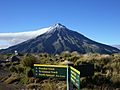
View of Taranaki from Stratford, showing Fanthams Peak on the southern flank
|
|
| Highest point | |
| Elevation | 2,518 m (8,261 ft) |
| Prominence | 2,308 m (7,572 ft) |
| Listing | Ultra New Zealand #65 |
| Geography | |

Mount Taranaki
Location in New Zealand
|
|
| Topo map | NZMS 169 Egmont National Park |
| Geology | |
| Mountain type | Stratovolcano |
| Last eruption | 1854 |
| Climbing | |
| First ascent | Ernst Dieffenbach & James Heberly, 1839 |
| Easiest route | Mount Taranaki Summit Track (trail) |
Mount Taranaki, also known as Mount Egmont, is a large, cone-shaped mountain on the west coast of New Zealand's North Island. It is a stratovolcano, which means it's a volcano built up by many layers of hardened lava, ash, and rock. Taranaki is currently dormant, meaning it's not erupting now but could erupt again in the future.
This impressive mountain is 2,518 metres (8,261 ft) tall. It has a smaller peak called Fanthams Peak (Māori: Panitahi), which is 1,966 metres (6,450 ft) high, on its southern side. Mount Taranaki looks a lot like Mount Fuji in Japan. Because of this, it was used as a background in the movie The Last Samurai.
Contents
Understanding the Mountain's Names
For hundreds of years, the Māori called this mountain Taranaki. The word tara means "mountain peak," and naki might come from ngaki, meaning "shining." This likely refers to the snow that covers the top of the mountain in winter. Māori tribes in ancient times also called it Pukehaupapa and Pukeonaki.
In 1770, Captain Cook named it Mount Egmont. He named it after John Perceval, who was an important leader in the British Navy. Cook described the mountain as "of a prodigious height and its top cover'd with everlasting snow."
Later, in 1772, another explorer named Marc-Joseph Marion du Fresne saw the mountain and called it Pic Mascarin. He didn't know that Captain Cook had already named it.
For a long time, maps only showed the name Mount Egmont. But in 1986, the New Zealand government made "Mount Taranaki" an official name too. So now, it has two official names. The national park around the mountain is still called Egmont National Park.
Volcanic Activity: When Taranaki Wakes Up
Mount Taranaki is a relatively young volcano, starting to form about 135,000 years ago. Its most recent activity was a small lava flow and collapse around the 1850s or 1860s. Before that, a larger eruption happened between 1755 and 1800, sending hot ash and gas down its sides.
Scientists have studied Taranaki's past eruptions. They found that small eruptions have happened about every 90 years on average over the last 9,000 years. Bigger eruptions have occurred roughly every 500 years.
What Are the Dangers of an Eruption?

Taranaki is special because it has had at least five major eruptions where parts of its cone collapsed. This is unusual for volcanoes. When the cone collapses, it sends huge amounts of material down the mountain, creating a wide, flat area around the base.
Another common danger from Taranaki is lahars. Lahars are like fast-moving rivers of mud, ash, and debris. They can travel far, even reaching the coast. Lahars don't even need an eruption to happen. Heavy rain or earthquakes can mix with unstable layers of rock and snow on the mountain, causing a lahar. Many farms are in areas that could be affected by these mudflows.
Scientists warn that a large eruption from Taranaki is "overdue" based on its past activity. If a big eruption happens, strong winds would likely carry ash to the east, covering much of the North Island. This could cause problems for air travel, power lines, and water supplies.
Older Volcanoes in the Area

Mount Taranaki sits on top of the remains of three older volcanoes. These older volcanoes are to the northwest of Taranaki. The Earth's crust is slowly moving over a hot spot deep underground that feeds these volcanoes. This movement explains why newer volcanoes form in different spots over time. Fanthams Peak, the smaller cone on Taranaki, is a newer part of the volcano.
The oldest volcanic remains are rocks called Paritutu rock and the Sugar Loaf Islands. These are about 1.75 million years old.
Further away, about 15 km southwest of New Plymouth, is the Kaitake range. This volcano was last active about 500,000 years ago.
The Pouakai complex is closer to Taranaki. It was active until about 240,000 years ago. Much of the Pouakai volcano was covered by the growth of Mount Taranaki.
Māori Legends About Taranaki

According to Māori legends, Taranaki once lived in the middle of the North Island with other volcanoes. There was a beautiful mountain named Pihanga, and all the mountains wanted her. A big battle broke out, and Tongariro won. Tongariro badly wounded Taranaki, forcing him to flee.
Taranaki moved west, creating deep gorges as he went. He paused, forming a swamp, then headed north. But the Pouakai ranges blocked his path. When the sun rose, Taranaki became frozen in his current spot.
Māori legends say that when Taranaki is covered in rainclouds, he is crying for his lost love, Pihanga. When there are beautiful sunsets, he is showing himself to her. And when Tongariro erupts, it's a warning to Taranaki not to return.
History of the Mountain

In 1865, the New Zealand government took control of the mountain from Māori. This happened during a time of conflict called the Second Taranaki War. The government's goal was to take land from Māori who were seen as rebelling and give it to settlers.
In 1839, a Swiss doctor and naturalist named Ernst Dieffenbach was one of the first Europeans to climb the mountain. He worked for the New Zealand Company, exploring the North Island and advising on land use.
In 1978, the mountain was given back to the Taranaki Māori people. However, through the same law, it was immediately given back to the government as a gift to the nation. Many Māori people later said they didn't know about or agree to this arrangement.
In 2017, a special agreement was made between the Taranaki tribes and the New Zealand government. This agreement means that the mountain will be treated as a "legal personality." This means it has rights, just like a person. Taranaki is one of only a few natural features in New Zealand to have this special status.
Egmont National Park
In 1881, a circular area around the mountain, about 9.6 km (6 miles) from the top, was made a protected Forest Reserve. Later, areas including the older Pouakai and Kaitake volcanoes were added. In 1900, all this land became Egmont National Park, New Zealand's second national park.
If you look at satellite images, you can clearly see the park's circular boundary. Outside the park, there are many dairy farms. Inside, you can find beautiful old growth forests with very old trees.
Fun Activities and Safety on Taranaki
The Stratford Mountain Club runs the Manganui skifield on the eastern side of the mountain. You can get equipment to the ski field using a special cable car system called a "flying fox" across the Manganui Gorge.
The Taranaki Alpine Club has a lodge called Tahurangi Lodge on the north side. This lodge is often used as a starting point for public climbs to the summit during summer. Climbing and hiking clubs organize these events and offer guides.
Climbing Mount Taranaki is considered a moderate challenge. A fit person can usually climb up and back down in one day. However, the weather on the mountain can change very quickly. This has surprised many hikers and climbers. Since 1891, 84 people have died on the mountain, often because of sudden weather changes. It is the second most dangerous mountain in New Zealand after Aoraki / Mount Cook.
Getting to Mount Taranaki
There are three roads that go part-way up the mountain:
- The highest road goes to the East Egmont plateau. Here you'll find a viewing platform and parking for the ski field.
- Park visitor centers are located at North Egmont and Dawson Falls on the southeast side.
- The eastern side from Stratford leads to the Stratford Mountain House and the ski field.
There is no road access on the western side. However, a 10 km (6 mile) road winds through native bush over the saddle between the Pouakai and Kaitake ranges. Near the top of this road is the famous Pukeiti Trust rhododendron garden.
Images for kids
-
Taranaki from the Pouakai Circuit tramping track
-
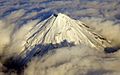
Aerial view of Mount Taranaki 2015


See also
 In Spanish: Monte Taranaki para niños
