
Sugar Loaf Islands facts for kids
|
Ngā Motu (Māori)
|
|
|---|---|

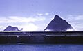
Motumahanga and Moturoa
|
|
| Geography | |
| Location | near Port Taranaki |
| Coordinates | 39°2′58″S 174°1′40″E / 39.04944°S 174.02778°E |
| Administration | |
| Demographics | |
| Population | 0 |
The Sugar Loaf Islands are a group of five small islands and some tall rocks called sea stacks. They are located near Port Taranaki in Taranaki, New Zealand. In the Māori language, they are called Ngā Motu, which means "the islands".
Long ago, these islands were home to the descendants of Te Whiti o Rongomai. The local Māori people, Ngāti Te Whiti, gave names to all the islands and reefs.
The biggest island is Moturoa Island, which is about 1.4 hectares (3.5 acres) in size. Motumahanga is the island furthest from the shore, about 1.5 kilometers (0.9 miles) away.
The Sugar Loaf Islands Marine Protected Area (SLIMPA) was created in 1991. This area helps protect the islands and the ocean around them. It stopped oil exploration and made the protection stronger.
The famous explorer James Cook gave the islands their English name in 1770. He thought they looked like the cone-shaped piles of sugar that were common in Europe back then.
In 2013, local leaders decided to give the Sugar Loaf Islands Marine Protected Area back to the New Zealand Government. This was part of an agreement with the Taranaki and Te Atiawa iwi (Māori tribes).
Contents
What are the Sugar Loaf Islands?
The Sugar Loaf Islands can be split into two main groups: inner islands and outer islands.
Inner Islands
The inner islands are closer to the mainland. They include Mataora (also called Round Rock), Pararaki (Seagull Rock), and Motuotamatea (Snapper Rock).
- Mataora connects to the mainland when the tide is low. It forms a natural bridge called a tombolo.
- Motuotamatea also connects to the mainland during very low spring tides.
- Pararaki is separated from Mataora by a narrow channel, about 20 meters wide.
Outer Islands
The outer islands are further from the shore. They are Motumahanga (Saddleback Island) and Moturoa.
Other Rocks and Stacks
There are also several smaller rock outcrops in the area.
- Waikaranga (Seal Rocks) and Tokatapu are a few hundred meters offshore.
- Close to Moturoa, you'll find Whareumu (Lion Rock), which has some plants growing on it, and two bare rocks.
- Tokomapuna (Barrett Reef) is another rock outcrop nearby.
Mikotahi: A Changing Island
Mikotahi was once an island that appeared at half tide. It was an important historic pā (a fortified Māori village) and later had a building for storing explosives. In 1865, the Alpha well was drilled near Mikotahi. This was one of the first oil wells in the world!
Later, land was reclaimed (filled in) to build the New Plymouth Power Station. This work made Mikotahi smaller and connected it permanently to the mainland. Today, a survey marker still stands on what's left of it.
Mikotahi also had a neighboring rock stack called Fishing Rock. It had caves, rockpools, and beaches. Sadly, most of it was destroyed during the power station's construction.
Blasting for Rock
In the early 1900s, parts of Moturoa Island and Whareumu (Lion Rock) were blasted with explosives. The idea was to connect these islands to Mikotahi and the growing port at Moturoa. However, this plan was stopped, and efforts then focused on mining the nearby Paritutu.
Because of this blasting, the shape of Moturoa and Whareumu changed a lot.
Human History on the Islands
For hundreds of years, the islands of Mataora, Motu-o-Tamatea, Moturoa Island, and Mikotahi were important places for people. The local Taranaki and Te Āti Awa Māori tribes used them for hunting, fishing, and gathering food. They also served as safe places to go during conflicts.
Protecting the Ocean Life
In 1986, the area around the Sugar Loaf Islands became a marine park. People were worried about oil exploration, so the protection was made stronger in 1991 with a special law.
This protected area covers about 752.5 hectares (1,859 acres) of ocean and 5.3 hectares (13 acres) of land. It stretches from Port Taranaki in the north to Herekawe Stream in the south. In this area, commercial and recreational fishing, as well as mining, are not allowed.
- Moturoa Island, Motumahanga, Waikaranga, and Whareumu are special sanctuary areas. You need a permit to enter these parts.
- The rest of the area is a conservation park.
Many interesting animals live in or visit this area, including:
- Reef herons
- Little blue penguins
- New Zealand Fur Seals
- Orcas (killer whales)
The islands are also on the migration paths for many oceanic birds and cetaceans (whales and dolphins).
In 2008, another protected area called the Tapuae Marine Reserve was created next to the Sugar Loaf Island Marine Protected Area.
How the Islands Were Formed
The Sugar Loaf Islands, along with rocks like Paritutu (which is 153 meters or 502 feet tall), are the oldest volcanoes in the Taranaki area. They formed about 1.7 to 1.74 million years ago. Scientists believe they are the remains of ancient volcanic vents that have worn away over time.
The islands are made of a type of rock called andesite. After these islands formed, volcanic activity moved to other places in Taranaki, like Kaitake (580,000 years ago), then Pouakai (230,000 years ago), and finally to the active volcano we know today, Mount Taranaki (which last erupted in 1755).
A special mineral called taranakite was first discovered on the Sugar Loaf Islands. This mineral forms when bird guano (poop) reacts with the rocks of the islands. It was the first new mineral found in New Zealand!
Images for kids
-
Motumahanga and Moturoa
