Ōwhango facts for kids
Quick facts for kids
Ōwhango
|
|
|---|---|
|
Town
|
|

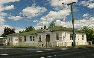
The old Owhango Post Office c. 1919
|
|
| Country | New Zealand |
| Region | Manawatū-Whanganui |
| District | Ruapehu District |
| Ward |
|
| Community | Ōwhango-National Park Community |
| Electorates |
|
| Area | |
| • Total | 0.61 km2 (0.24 sq mi) |
| Population
(June 2023)
|
|
| • Total | 190 |
| • Density | 311/km2 (807/sq mi) |
Ōwhango is a small town in New Zealand. It is located about 20 kilometers (12 miles) south of Taumarunui on State Highway 4. The town is also about 2 kilometers (1.2 miles) west of the Whakapapa River, which flows into the Whanganui River.
The name Ōwhango became official on July 16, 2020. It is a Māori name that means "the place of wheezy noises."
Ōwhango is surrounded by beautiful native forest and has views of Mount Ruapehu. You can often see native birds like tūī and kererū flying around. The town's main park, called the domain, is set within this native forest. It has large open fields for playing, a children's play area, and two tennis courts.
A railway line, called the Main Trunk Line, runs through Ōwhango. There are two places where vehicles can cross the railway tracks. From 1905 to 1985, Ōwhango even had its own railway station.
Contents
Exploring Ōwhango's Geography
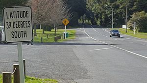
Ōwhango is special because it sits right on the 39° latitude line. Latitude lines are imaginary lines that go around the Earth, telling us how far north or south a place is from the Equator. This location used to mark the boundary between the old Auckland and Wellington regions.
You'll find a sign in Ōwhango that says "39° South." This sign is very accurate for its time.
Discovering the Ohinetonga Scenic Reserve
The native forest around Ōwhango is part of the Ohinetonga Scenic Reserve. This reserve protects old, untouched native forest with huge trees. There's a lovely lagoon you can reach by following a walking track.
A road through the reserve leads to a viewpoint from an old logging bridge over the Whakapapa River. Along the river, there are great spots for picnics and swimming. The clear pools are home to rainbow and brown trout. This river is also a starting point for kayakers heading towards Kakahi or even further down the Whanganui River.
Beyond the bridge lies the vast Tongariro Forest Conservation Area. This area was once used for timber, but thanks to local efforts in the 1980s, it is now protected. One of New Zealand's best mountain bike trails, the 42 Traverse, cuts through this forest. The forest is also great for hiking, camping, and deer hunting. Deep inside the forest, there's a special sanctuary for the North Island Brown Kiwi, where the Department of Conservation works to protect these unique birds from predators.
A Look at Ōwhango's Past
Ōwhango started as a town focused on milling, which means cutting down native trees for timber. The last working mill in the area burned down in the 1970s. Many of the old mill houses are now holiday homes for people from the city. They come to Ōwhango to enjoy activities like skiing, fishing, hunting, canoeing, and hiking in the beautiful surrounding area.
In 2013, Ōwhango had 177 permanent residents. The village has a primary school, a hotel, places to stay like lodges and cottages, and a café. There's also a public hall where a monthly market is held.
Historical Swimming Pool
There's a historic swimming pool built right into the Kakahi Stream, about 500 meters (0.3 miles) west of State Highway 4. Locals created this pool hoping to help a local athlete train for the British Empire and Commonwealth Games. Next to the pool is a monument celebrating 100 years of the Treaty of Waitangi. Records show the pool was first used in the summer of 1939/1940. Later, in 1961, a more modern swimming pool opened at the local school.
Ōwhango Hall and Fire Brigade
The Ōwhango Hall was originally a cinema that could seat 250 people, showing silent movies. Today, it's mainly used for community meetings, indoor bowls, and market days. The Ōwhango Volunteer Fire Brigade has been helping the community since 1965.
Ōwhango's Community and People
Ōwhango is considered a rural settlement. In 2018, it had a population of 174 people. There were 75 households, with slightly more females than males. The average age was 44.9 years. About 20% of the population was under 15 years old.
Most people in Ōwhango identify as European/Pākehā, but a significant number also identify as Māori. Farming and tourism are the biggest employers in the area.
Sports and Fun Events
|
||||
Local sports teams in Ōwhango usually wear green and white. In the 1950s, the Ōwhango Domain was a popular place for an annual sports day for the region. It's still used for occasional sports and school events today.
The Ōwhango Hall is big enough for indoor bowls and even a badminton court.
Some regular events in Ōwhango include the annual Pumpkin Growing Competition, monthly community markets, and the yearly T42 mountain biking, running, and walking event.
Learning in Ōwhango
Owhango School is a primary school for students from Year 1 to Year 8. It teaches both boys and girls. As of November 2023, the school has 14 students.
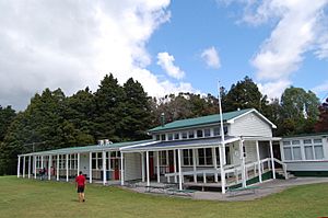
The very first schooling in Ōwhango happened in canvas tents around 1904, when the railway line was being built. The first permanent school building opened in 1910. The current school buildings were built around 1970.
The Taumaranui Mobile Library visits the school regularly. This helps children living in remote areas get access to books.
Notable People from Ōwhango
- Don Rowlands, a famous rower
 | Jewel Prestage |
 | Ella Baker |
 | Fannie Lou Hamer |


