
Whakapapa River facts for kids
Quick facts for kids Whakapapa River |
|
|---|---|

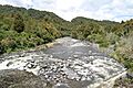
Whakapapa River near Owhango
|
|

|
|
| Native name | Whakapapa |
| Country | New Zealand |
| Region | Manawatū-Whanganui |
| District | Ruapehu |
| Physical characteristics | |
| Main source | Mount Ruapehu Whakapapa skifield 39°15′40″S 175°33′50″E / 39.26111°S 175.56389°E |
| River mouth | Whanganui River 255 m (837 ft) 38°55′48″S 175°24′28″E / 38.93000°S 175.40778°E |
| Length | 65 km (40 mi) |
| Basin features | |
| Progression | Whakapapanui Stream → Whakapapa River → Whanganui River |
| River system | Whanganui River |
| Waterfalls | Tawhai Falls |
The Whakapapa River is a beautiful river in New Zealand. It starts high up on Mount Ruapehu, flowing from the Whakapapa skifield. The river then travels down the western side of the mountain. It passes close to a town called Ōwhango. Finally, the Whakapapa River joins with the larger Whanganui River near Kakahi.
Contents
Exploring the Whakapapa River
The Whakapapa River offers exciting adventures for those who love the outdoors. It's a great place to experience nature.
Can You Kayak on the Whakapapa River?
Yes, you can! Some people enjoy kayaking on a special part of the river. This section is about 7.5 kilometers (4.7 miles) long. It stretches from near Ōwhango to an area close to Kakahi. It's a fun way to see the river up close.
Where Does the Whakapapa River Flow?
The Whakapapa River has a clear path from its beginning to where it ends. It collects water from smaller streams along the way.
What Are the Whakapapa River's Main Tributaries?
A tributary is a smaller stream or river that flows into a larger one. The Whakapapa River has several of these.
| Tributary Name | Length (km) | Distance From Mouth (km) | Where It Joins (Coordinates) |
|---|---|---|---|
| Mount Ruapehu | River Source | 39°15′40″S 175°33′50″E / 39.26111°S 175.56389°E | |
| Tepure Stream | 39°03.54′S 175°23.78′E / 39.05900°S 175.39633°E | ||
| Whanganui River | River Mouth | 0 km | 38°55′48″S 175°24′28″E / 38.93000°S 175.40778°E |
Images for kids
-
Whakapapa River near Owhango
