Waipā District facts for kids
Quick facts for kids
Waipa District
|
|
|---|---|
|
Territorial authority district
|
|

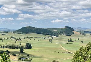
Te Kawa from Kakepuku
|
|
 |
|
| Country | New Zealand |
| Region | Waikato |
| Wards | Te Awamutu Cambridge Pirongia Maungatautari Kakepuku |
| Seat | Te Awamutu |
| Area | |
| • Land | 1,470.07 km2 (567.60 sq mi) |
| Population
(June 2023)
|
|
| • Territorial | 61,100 |
| Postcode(s) |
Map of postcodes
|
| Area code(s) | 07 |
| Website | Waipa District Council |
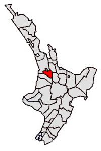
The Waipa District is a special area in the Waikato region of New Zealand. It is managed by the Waipa District Council, which is like the local government for the area. The biggest town in Waipa District is Cambridge. The main office for the council is in Te Awamutu, which is the second largest town.
The district is located south and southeast of the city of Hamilton. It is divided into five smaller areas called wards: Te Awamutu, Cambridge, Pirongia, Maungatautari, and Kakepuku. Even though the official name is Waipa District, the council has been working to change it to Waipā District, which is how it is often written.
Contents
A Look Back: Waipa's History
The Waipa District was officially created in 1989. Before that, it was known as the Waipa County Council. A county council was an older type of local government.
How the District Grew
The county's borders have changed over time. In 1876, Waipa county was divided into five smaller areas called ridings. These were Newcastle, Hamilton, Mangapiko North and South, Rangiaowhia, and Pukekura.
By 1902, the area covered about 730 square kilometers (282 square miles). It also had a new riding called Tuhikaramea. In 1923, the county had grown to about 1,111 square kilometers (429 square miles). At that time, about 9,275 people lived there. The roads were a mix of gravel, mud, and simple tracks.
Exploring Waipa's Geography
The Waipa District is known for its beautiful natural features. Two important rivers flow through or near it.
Rivers and Mountains
The Waikato River forms most of the eastern edge of the district. It then flows northwest through the district, passing by Cambridge. The Waipā River is the main river that flows into the Waikato River. It flows north through the western part of the district. These two rivers meet just outside the district.
The district also has two tall mountains. Mount Pirongia is in the west, and Maungatautari is in the east. These mountains add to the district's stunning scenery.
Economy and Resources
The economy of the Waipa District mainly relies on farming. Dairy farming, which produces milk, and growing cereal crops are very important here. The southeastern part of the district is also home to the hydroelectric project at Karapiro. This project uses water power to create electricity.
Who Lives in Waipa: Demographics
The Waipa District covers about 1,470 square kilometers (568 square miles). It is home to many people, and its population has been growing.
Population and Density
As of 2023, the Waipa District had a population of 58,686 people. This means there are about 40 people living in each square kilometer. This number has increased by 5,445 people since 2018. The population has grown by 12,018 people since 2013.
There are 23,505 homes in the district. The average age of people living here is 40.9 years old. About 20% of the population is under 15 years old. About 19.4% of people are 65 years or older.
Different Backgrounds
People from many different backgrounds live in Waipa District.
- About 86.5% of people are New Zealand European, also known as Pākehā.
- About 15.9% are Māori.
- About 2.3% are Pasifika.
- About 6.1% are Asian.
- A small number are from the Middle East, Latin America, and Africa.
- About 1.3% identify with other ethnic groups.
Some people identify with more than one ethnic group.
Education and Jobs
Many people in Waipa District have good education. About 19.4% of people aged 15 and over have a university degree or higher. The average income in the district is about $35,500 per year.
Most adults in Waipa District are employed. About 51.9% work full-time, and 15.0% work part-time. Only about 3.0% of people are unemployed.
Wards at a Glance
The Waipa District is divided into five wards, each with its own population and characteristics.
| Name | Area (km2) | Population | Density (per km2) | Households | Median age | Median income |
|---|---|---|---|---|---|---|
| Pirongia Ward | 439.14 | 8,766 | 19.96 | 2,991 | 39.2 years | $40,500 |
| Cambridge Ward | 73.67 | 20,472 | 277.89 | 7,728 | 42.4 years | $34,900 |
| Maungatautari Ward | 437.26 | 4,191 | 9.58 | 1,461 | 39.0 years | $43,200 |
| Te Awamutu Ward | 55.28 | 15,891 | 287.46 | 5,973 | 40.4 years | $30,700 |
| Kakepuku Ward | 464.72 | 3,918 | 8.43 | 1,362 | 36.4 years | $38,900 |
| New Zealand | 37.4 years | $31,800 |

