
Mount Pirongia facts for kids
Quick facts for kids Mount Pirongia |
|
|---|---|

Mt. Pirongia, 4 April 2008
|
|
| Highest point | |
| Elevation | 959 m (3,146 ft) |
| Naming | |
| English translation | "Pirongia te aroaro o Kahu" - The scented pathway of Kahu |
| Geography | |
| Location | North Island, New Zealand |
| Parent range | Hakarimata Range |
| Topo map | NZMS 260 S15 Te Awamutu |
| Geology | |
| Age of rock | Pliocene |
| Mountain type | Stratovolcano (extinct) |
Mount Pirongia is an extinct stratovolcano in New Zealand. It's found in the Waikato region of the North Island. It stands 959 metres tall. This makes it the highest mountain in the Waikato region.
Mount Pirongia was an active volcano about 2.5 million years ago. Its many peaks are basaltic cones. They were formed by many volcanic eruptions.
Contents
History and Name
Maori people have a strong connection to Mount Pirongia. Its original name is "Pirongia te aroaro o Kahu". This means "the scented pathway of Kahu." A tohunga (a skilled expert or priest) from the Tainui canoe gave it this name. He did it to honour his wife.
In 2002, the Pirongia Te Aroaro o Kahu Restoration Society Inc was formed. This group works to protect Mount Pirongia's natural environment. They want to restore its plants and animals.
Location and Surroundings
Mount Pirongia is located 22 kilometres west of Te Awamutu. It is also eight kilometres from the small town of Pirongia. The mountain is part of the Pirongia Forest Park.
You can easily see Mount Pirongia from the Tasman Sea. It is only 25 kilometres from the coast. This includes places like Aotea Harbour.
Plants and Animals
Mount Pirongia is home to many different plants and animals. A very rare plant called Wood Rose (or Dactylanthus taylorii) grows here. It is a parasitic flowering plant. You can find it on the ridges of the mountain.
At lower parts of the mountain, you'll find many podocarp trees. These include rimu, totara, tawa, and tree ferns. As you go higher, the forest changes. Hardy plants like horopito and kamahi grow on exposed ridges. Near the top, you'll see mountain flax, coprosmas, and ferns.
Common birds in the area include fantails, kingfishers, tui, kereru, and New Zealand falcons.
Mount Pirongia is also special for its plants. It marks where northern kauri forests meet southern beech and podocarp-beech forests. Some plants, like kauri and mangeao, naturally stop growing this far south.
Tracks and Huts
There are many walking tracks to the summit of Mount Pirongia. The Mahaukura - Tirohanga Circuit is a long track. It takes about 8 to 11 hours to complete. This track has a gradual climb. It is well marked with bright orange markers.
The track goes through many steep parts. But it offers great views from Wharauroa lookout. You can also see amazing sights from Mahaukura peak (899 m) and Tirohanga peak. In winter or after rain, the track can get muddy and slippery. Some parts are narrow with tree roots and rocks.
From the Pirongia summit lookout, you can see far on a clear day. You might spot Mount Taranaki and Mount Ruapehu. To the west, you can see Kawhia and Raglan harbours.
Between the Summit and The Cone, there is a hut built in 2015. It has 20 bunks for people to sleep in. An older hut with 6 bunks is right next to it. Many tracks near the summit now have boardwalks. Some of these boardwalks are part of the Te Araroa long-distance trail.
Images for kids
-
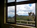
View from the new hut looking south.
-
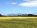
Mount Pirongia viewed from a distance (approx Feb 2013); the profile is clearly shown as is the secondary cone to the right of the mountain.
-
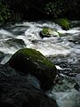
River on Pirongia
-
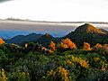
Central plateau from near Pahautea Hut at sunset
-
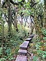
Boardwalk on Bell Track in pahautea grove. It is gradually being extended towards The Cone.

.png)


