
Moawhango River facts for kids
Quick facts for kids Moawhango River |
|
|---|---|
| Country | New Zealand |
| Physical characteristics | |
| Main source | Kaimanawa Range |
| River mouth | Rangitikei River |
| Length | 62 km (39 mi) |
The Moawhango River is a cool river found in the middle of New Zealand's North Island. It's a branch of the bigger Rangitīkei River.
Where the River Flows
The Moawhango River starts high up in the Kaimanawa Range. This is about 35 km (22 mi) east of Mount Ruapehu. The river flows southwest until it reaches Lake Moawhango.
Lake Moawhango was made by building a dam. This dam is located in the Waiouru Military Camp training area. It's about 10 km (6 mi) north of Waiouru. The dam helps to send some of the river's water to the Tongariro Power Scheme. This scheme uses water to make electricity. Some water is also released to keep flowing down the Moawhango River.
From the lake, the river flows southeast. It passes by a small town called Moawhango. Finally, it flows into the Rangitīkei River about 8 km (5 mi) southeast of Taihape. The lower part of the river flows through steep, narrow valleys. This makes it a bit tricky to get to.
The Moawhango Dam
The dam on the Moawhango River was started in 1972 and finished a few years later. It's an important part of the Tongariro Power Scheme. The water from the dam is sent to the Rangipo power station, which helps make electricity for people. In 2008, some people talked about how taking water from the river might affect it.
Fishing in the River
The Moawhango River is a great spot for fishing! It's known for having lots of trout. You can mostly find brown trout and rainbow trout here.
Images for kids
-
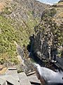
Outfall from Lake Moawhango
-
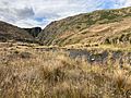
Moawhango River downstream of Lake Moawhango


