
Lake Moawhango facts for kids
Quick facts for kids Lake Moawhango |
|
|---|---|

Lake Moawhango
Location in North Island
|
|
| Location | Waiouru, North Island |
| Coordinates | 39°23′35″S 175°45′11″E / 39.393°S 175.753°E |
| Primary outflows | Moawhango Tunnel to Tongariro River |
| Basin countries | New Zealand |
Lake Moawhango is a small, man-made lake found in the Waiouru Military Camp area in New Zealand. This special lake gets its water from several sources. These include the Mangaio Stream and other small streams that flow down from the slopes of Mount Ruapehu. The Moawhango River also helps to fill the lake.
Lake Moawhango is important because its water is used for a big project called the Tongariro Power Scheme. This scheme helps to create electricity. Water from the lake travels through a long underground path called the Moawhango Tunnel. It then flows into the Tongariro River. However, some water is also released from the lake to continue flowing down the Moawhango River, near a small town called Moawhango. A dam at the southern end helps to hold the lake's water in place.
Contents
Discovering Lake Moawhango
Lake Moawhango is located in the central part of New Zealand's North Island. It sits within a special training area used by the New Zealand Army. This makes it a unique place to visit.
How the Lake Was Formed
Lake Moawhango is not a natural lake. It was created by people building a dam. This dam holds back the water from the streams and rivers that feed into it. This is why it's called an "artificial" lake.
Water Sources and Uses
The lake gets its water from a few places. The main ones are the Mangaio Stream and the Moawhango River. There are also smaller streams that bring water from the famous Mount Ruapehu. This mountain is a large volcano in New Zealand.
The water from Lake Moawhango plays a big role in generating power. It flows into the Tongariro Power Scheme, which uses the water's movement to make electricity. This power helps light up homes and businesses.
Wildlife in the Lake
Lake Moawhango is home to many fish. It has a large number of wild rainbow trout. These fish are quite easy to catch if you enjoy fishing.
Rainbow Trout in the Lake
Even though there are many rainbow trout in the lake, they usually stay quite small. Most of them weigh less than 2 pounds (0.9 kg). This means they are often about the size of a small football.
Islands of Lake Moawhango
The lake also has three islands. The biggest one is known as Ayers Rock. These islands add to the lake's natural beauty.
A Fun Fact About the Lake
Did you know that if you dug a straight tunnel right through the Earth from Lake Moawhango, you would come out in a very specific spot? This spot is exactly where the Torre de Abraham dam is located in Castilla - La Mancha, Spain! This opposite point on Earth is called an "antipode."
Images for kids
-
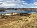
Lake Moawhango from the west side, looking east in January 2022.
-
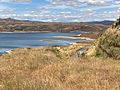
Lake Moawhango looking south towards the Moawhango Dam in January 2022.
-
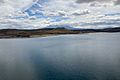
Lake Moawhango looking north-west towards Mt Ruapehu in January 2022.
-
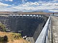
Lake Moawhango and Mt Ruapehu, seen from the Moawhango Dam in January 2022.


