Whanganui District facts for kids
Quick facts for kids
Whanganui District
|
|
|---|---|
|
Territorial authority district
|
|

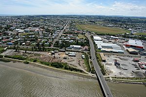
Whanganui River Bridge View from Helicopter
|
|
 |
|
| Country | New Zealand |
| Region | Manawatū-Whanganui |
| Seat | Whanganui |
| Area | |
| • Land | 2,373.27 km2 (916.32 sq mi) |
| Population
(June 2023)
|
|
| • Total | 48,900 |
| Time zone | UTC+12 (NZST) |
| • Summer (DST) | UTC+13 (NZDT) |
| Postcode(s) |
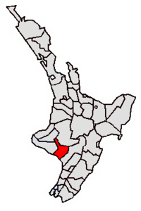
Map of postcodes
|
The Whanganui District is a special area in New Zealand. It includes the main city of Whanganui and all the land around it. This district is run by the Whanganui District Council.
Contents
Discovering Whanganui Geography
The Whanganui District covers about 2,373 square kilometers. A big part of this area is made up of hilly land. These hills surround the beautiful valley of the Whanganui River.
Much of this land is protected within the Whanganui National Park. This park helps keep the natural environment safe.
How the District Got Its Name
The district was once spelled "Wanganui". But in 2015, its name was officially changed to Whanganui District. This change made the district's name match the spelling of the famous Whanganui River. This happened because the local council asked for the change.
People and Population in Whanganui
The Whanganui District is home to many people. As of 2023, about 47,619 people live here. Most of these people live in the city of Whanganui itself.
There are not many large towns outside the main city. However, a small but well-known village is Jerusalem.
Population Changes Over Time
The number of people living in Whanganui District has grown. In 2013, there were 42,153 residents. By 2018, this number increased to 45,309. The latest count in 2023 showed 47,619 people. This means the population grew by 5.1% since 2018.
| Historical population | ||
|---|---|---|
| Year | Pop. | ±% p.a. |
| 2006 | 42,636 | — |
| 2013 | 42,153 | −0.16% |
| 2018 | 45,309 | +1.45% |
| 2023 | 47,619 | +1.00% |
| Ethnicity | Population |
|---|---|
| New Zealand European |
37,284
|
| Māori |
13,566
|
| Pasifika |
1,965
|
| Asian |
2,415
|
| MELAA |
270
|
| Other |
669
|
Who Lives in Whanganui?
The people of Whanganui District come from many different backgrounds. In 2023, about 78.3% of residents were European/Pākehā. About 28.5% were Māori. There were also people from Pasifika (4.1%) and Asian (5.1%) backgrounds. Some people identify with more than one ethnic group.
The median age in the district is about 42.9 years old. This is a bit older than the national average in New Zealand, which is 38.1 years.
 | Jackie Robinson |
 | Jack Johnson |
 | Althea Gibson |
 | Arthur Ashe |
 | Muhammad Ali |

