Stratford District, New Zealand facts for kids
Quick facts for kids
Stratford District
|
|
|---|---|
|
Territorial authority district
|
|

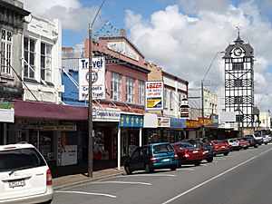
Stratford main street
|
|
 |
|
| Country | New Zealand |
| Region | Taranaki |
| Wards |
|
| Seat | Stratford |
| Area | |
| • Total | 2,163.42 km2 (835.30 sq mi) |
| Population
(June 2023)
|
|
| • Total | 10,300 |
| • Density | 4.761/km2 (12.33/sq mi) |
| Time zone | UTC+12 (NZST) |
| • Summer (DST) | UTC+13 (NZDT) |
| Postcode(s) |
Map of postcodes
|
| Area code(s) | 06 |
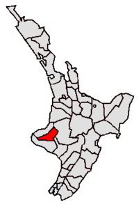
The Stratford District is a special area in the North Island of New Zealand. It's managed by the Stratford District Council, which has its main office in the town of Stratford. This district is unique because it's split between two regions: the Manawatū-Whanganui region and the Taranaki region. Most of the district (about 68%) is in Taranaki.
The district covers a large area of about 2,163 square kilometers. In 2018, its population was around 9,474 people. This included about 5,784 people living in the main town of Stratford and the rest in smaller rural areas. The current mayor, Neil Volzke, has been leading the district since 2009.
Contents
How the Council Started
The local government in Stratford has changed over the years. It all began in 1882 with the first Stratford Town Board. Later, a County Council was formed in 1890, and a Borough Council in 1898. These two councils worked separately for many years.
Joining Forces: The District Council
In 1989, a big change happened across New Zealand with local government. The Stratford County Council and the Stratford Borough Council decided to merge. They became one single body: the Stratford District Council. This made managing the area simpler and more efficient.
Who Has Led Stratford?
Many people have served as leaders in Stratford's history. Before the merger, there were Town Chairmen, Borough Mayors, and County Chairmen. After 1989, the leaders became known as District Mayors.
- The first Town Chairman was George Newsham Curtis (1882–1885).
- Some notable Borough Mayors included Percy Thomson (who served multiple times) and Norman Harold Moss.
- The first Stratford District Council Mayor was David Walter, who led from 1989 to 1998.
- The current mayor is Neil Volzke, who started in 2009.
Who Lives in Stratford District?
The Stratford District is home to a diverse group of people. In 2023, the population was 10,149, which was an increase from previous years. The average age of people living here is about 40 years old.
| Ethnicity | Population |
|---|---|
| New Zealand European |
9,156
|
| Māori |
1,587
|
| Pasifika |
177
|
| Asian |
345
|
| MELAA |
39
|
| Other |
162
|
| Historical population | ||
|---|---|---|
| Year | Pop. | ±% p.a. |
| 2006 | 8,889 | — |
| 2013 | 8,988 | +0.16% |
| 2018 | 9,474 | +1.06% |
| 2023 | 10,149 | +1.39% |
Most people in the district identify as European/Pākehā (about 90%). There is also a significant Māori population (about 15.6%), along with smaller groups of Pasifika, Asian, and other ethnicities. Many people identify with more than one ethnic group.
When it comes to beliefs, about half the population (50.2%) said they had no religion in the 2018 census. About 37.7% identified as Christian, with smaller numbers following Māori religious beliefs, Hinduism, Buddhism, or other religions.
What Does the Land Look Like?

The Stratford District has some amazing natural features. It covers about a quarter of the Taranaki Region and includes four main parts: the Taranaki volcano, the flat land around it, the Pātea River area, and the eastern hill country.
Mount Taranaki: A Volcano's Presence
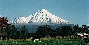
The famous Mount Taranaki is partly within the Stratford district. The highest point of the district is the 2518-meter peak of this mountain. You can drive up Pembroke Road from Stratford to a place called "The Plateau," which is 1172 meters high. From there, you can hike to the Manganui skifield.
On the other side of the mountain, Manaia Road leads to Dawson Falls and the Konini Lodge, which is 890 meters up. You can also find the natural Wilkies Pools nearby.
The Fertile Ring Plain
Around Mount Taranaki is a gently sloping area called the volcanic ring plain. This land is very flat and has rich volcanic soils. With plenty of rainfall, it's perfect for growing pasture and crops. This is why you see so many farms here! Three main rivers flow through this area: the Manganui River to the north, the Waingongoro River to the south, and the larger Pātea River.
The Pātea River's Journey
The Pātea River starts high up on the eastern side of Mount Taranaki, right above Stratford. It flows east, and Stratford town itself sits on its banks. The river then widens and flows through areas that used to be swamps, like Ngaere and Toko. It continues through the eastern hills, collecting water from many smaller streams, before heading south and eventually reaching the sea at Patea.
Exploring the Eastern Hills
East of Stratford, the district stretches for about 45 kilometers. This area is full of steep hills made of sandstone and mudstone, with winding valleys. Much of this hilly and isolated land is covered in native forests or tree farms. The rest is used for sheep and beef pastoral farming.
This eastern hill country is quite remote. The Whangamōmona River and Tangarakau River flow through here, eventually joining the Whanganui River. This part of the district is separated from the west by a thick forest, making it a unique and isolated place.
Villages Around Stratford
Stratford is surrounded by many small villages and settlements. To the north, you'll find Midhirst and Waipuku. To the south is Ngaere. West of Stratford, closer to the mountain, are places like Cardiff and Pembroke. To the northeast are Wharehuia and Te Popo.
East along State Highway 43, you'll find villages that were once very busy. Toko and the famous Whangamōmona still feel like lively villages. Other places like Douglas and Strathmore are now just a few houses.
Gateway to National Parks
Stratford is a great starting point for exploring two amazing National parks:
- Egmont National Park is to the west, surrounding Mount Taranaki.
- Whanganui National Park is to the east, offering beautiful natural landscapes.
What Does Stratford District Do?
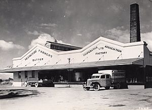
The economy of Stratford District is mainly based on farming. The rich volcanic soil and good rainfall make it one of the best places in New Zealand for dairy farming. There are thousands of dairy cows here! The hillier eastern parts of the district are used for raising beef cattle and sheep, and also for forestry (growing trees for wood).
Besides farming, the energy and tourism industries are becoming more important. The Stratford Power Station, which helps produce electricity, is located just east of the town.
Learning in Stratford District
Stratford District has several schools for children and teenagers.
Secondary Schools
There are two high schools in Stratford:
- Stratford High School
- Taranaki Diocesan School for Girls
Primary Schools
Within Stratford town, there are three primary schools:
- Stratford Primary School
- Avon School
- St Joseph's School
In the wider district, there are seven other primary schools, many of which were formed by combining smaller schools over the years:
- Midhirst School
- Ngaere School
- Pembroke School
- Toko School
- Huiakama School
- Marco School
- Makahu School
Stratford's Sister Cities
Stratford, New Zealand, is part of a special program called the Stratford Sister Cities. This program helps promote friendship and cultural exchange between different places around the world that are also named "Stratford." To join, a place usually needs to have a Shakespeare Theatre or Festival. Every two years, one of the member cities hosts a reunion.
The five main sister cities of Stratford, New Zealand are:
 Stratford-upon-Avon, England
 Stratford, Victoria, Australia
 Stratford, Ontario, Canada
 Stratford, Connecticut, United States
 Stratford, Prince Edward Island, Canada
 | Ernest Everett Just |
 | Mary Jackson |
 | Emmett Chappelle |
 | Marie Maynard Daly |


