Matapuna railway station facts for kids
Quick facts for kids
Matapuna railway station
|
|||||||||||
|---|---|---|---|---|---|---|---|---|---|---|---|

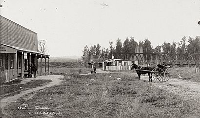
Matapuna in 1909.
The cottage is probably the bridge-keeper's |
|||||||||||
| Location | New Zealand | ||||||||||
| Coordinates | 38°52′53″S 175°17′36″E / 38.881500°S 175.293400°E | ||||||||||
| Elevation | 180 m (590 ft) | ||||||||||
| Line(s) | North Island Main Trunk | ||||||||||
| Distance | Wellington 394.8 km (245.3 mi) | ||||||||||
| History | |||||||||||
| Opened | 22 June 1903 | ||||||||||
| Closed | 31 March 1987 | ||||||||||
| Electrified | June 1988 | ||||||||||
| Services | |||||||||||
|
|||||||||||
| Designated: | 27 March 2009 (bridge) | ||||||||||
| Reference #: | 9277 | ||||||||||
Matapuna was a place with several railway tracks, called sidings. It was located on the main railway line of New Zealand's North Island. This area is in the Ruapehu District, near the town of Taumarunui. Matapuna served the eastern part of Taumarunui, which is on the north side of the Whanganui River.
The railway work in Matapuna was mostly finished by May 1903. Trains started carrying goods from June 22, 1903. Signals were put in place to help control the trains. One signal was at the station, and another was near the bridge. Before the railway arrived, a Ngāti Hauā village, called a kāinga, was on the south side of the river. People could cross the river there, except when it was flooding.
Contents
Matapuna Bridge: A Historic Crossing
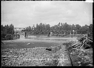
The Matapuna Bridge is a very important part of the railway line. It is located southeast of where the station used to be. This bridge carries the North Island Main Trunk (NIMT) railway line over the Whanganui River.
How the Bridge Was Built
The bridge is 470 ft (140 m) long. It has three large steel sections, each 122 ft (37 m) long. These are called through trusses, which means the train travels through the middle of the bridge's framework. There are also two shorter steel sections at each end.
Construction of the bridge began in March 1903 and finished in January 1904. It was built by a company called Scott Bros. Ltd. The design for the bridge was likely created by Peter Seton Hay. He was the chief engineer for the Public Works Department at that time.
Changes and Repairs Over Time
The Matapuna Bridge has been repaired and made stronger many times. This happened in 1916, 1938, 1956, 1965, 1967, and 2006. Even with all these changes, some original parts from 1903 are still there. These include the central cast iron piers and their pointed ends, which help cut through water.
From 1905 until May 1962, the Matapuna Bridge was special. It was a road-rail bridge, meaning both trains and cars could use it! Bridge-keepers controlled the traffic to make sure everyone was safe. The road part of the bridge was 11 ft (3.4 m) wide. Road traffic stopped using the bridge when a new concrete bridge opened nearby for State Highway 4. Today, the Matapuna Bridge is known as Bridge 197. It is about 750 m (2,460 ft) south of where the old station was.
Puketapu Sawmilling Co Ltd: Timber and Trains
The area around Puketapu was known for its valuable totara trees as early as 1903. These trees were great for timber. In 1905, a company called Puketapu Sawmilling Co Ltd started looking for people to cut down trees. They also wanted to build a small railway, called a bush tramway, which was 1.5 mi (2.4 km) long.
Sawmill Operations
The sawmill was probably working by 1906. At first, they tried floating cut timber down the river. Another sawmill was also operating nearby in 1906. Puketapu Sawmilling Co Ltd might have taken over this other mill by 1908. By then, their bush tramway was 5 mi (8.0 km) long.
The company faced problems and went out of business in 1909. However, another company, Pukuweka Sawmills, took it over. The bush tramway was connected to the main railway line. By 1911, the sawmill had two small locomotives to move timber. The last time the mill was recorded using the railway siding was in 1915.
Ballast Pit: Rocks for the Railway
Most of the original ballast for the central part of the North Island Main Trunk railway came from Matapuna. Ballast is the crushed rock that railway tracks sit on. It helps keep the tracks stable and drains water away. This ballast was taken from the river at a special area called the ballast reserve. This pit was just north of the bridge and was used from 1903 onwards.
 | Madam C. J. Walker |
 | Janet Emerson Bashen |
 | Annie Turnbo Malone |
 | Maggie L. Walker |


