
Retaruke River facts for kids
The Retaruke River is a river in the North Island of New Zealand. It flows into the Whanganui River near a place called Wade's Landing, which is downstream from Taumarunui. The river goes through the farming areas known as the Upper and Lower Retaruke Valley. Further downstream from where the rivers meet, you'll find Mangapurua Landing and the famous Bridge to Nowhere. This bridge was built for a farming community that didn't last.
Contents
Whakahoro: A Historic River Stop
Whakahoro (39°6.65′S 175°3.98′E / 39.11083°S 175.06633°E) is a small settlement located right where the Retaruke and Whanganui rivers join. It used to have several streets, like Lover's Lane and Dempsey Ave, but it's mostly empty now.
The Old Whakahoro School
The old Whakahoro School building is still there. It has been turned into a hostel where people who canoe down the river can stay overnight. The current Lacy's Bridge crosses the Retaruke River here. This bridge was built in 1932, replacing an older one from 1915–16.
Wade's Landing: A Busy Past
Historically, Wade's Landing at Whakahoro was a very important stop for riverboats. These boats traveled up and down the Whanganui River. The landing was just below where the Retaruke River meets the Whanganui. In the past, wool from the sheep farms in the Retaruke Valley was sent from here to Wanganui to be exported.
Lacy's Hotel and Community Gatherings
Just above the river junction, you can still see Lacy's hotel, which is now a farmhouse. It used to have its own landing and tennis courts. In the 1920s, people from the area would gather here for friendly games of Rugby union. There was even a riverboat (Image) that stayed anchored at the junction. This boat was a special place for people to meet, especially since certain areas nearby had strict rules about gatherings.
Land Use Changes and Modern Travel
Across the Whanganui River, there was once a Māori community. Later, this land was leased for sheep farming by the Rusling family. Now, it has returned to natural regrowth. Today, you can hire a jetboat locally to travel up the river to Taumarunui or down to Pipiriki and Jerusalem. Wade's Landing is even marked on modern GPS maps because of its historical importance for river travel.
Lower Retaruke Valley: Farming Life
Parts of the Lower Retaruke Valley were settled around 1900. The government offered some land through a farm ballot, while other parts were bought directly from the Māori community. Settlers cleared the land, planted grass, and brought in sheep from Raurimu to graze on the hills.
Community Hubs and Events
The valley once had a small school called Mangaroa Primary School (39°7.22′S 175°8.06′E / 39.12033°S 175.13433°E). Further up the valley, you can still find the community hall and a sports field. These places host annual children's Christmas parties, occasional dances, and the yearly Retaruke Easter Sports Day.
Getting to the Valley
You can reach the valley by three main roads: Oio Road, Kawautahi Road, or the Raurimu-Kaitieke Road from Raurimu. You can also walk in using the old Mangapurua Road, or travel by jetboat or via the Whanganui River. Some old roads, like Kokako Road and Kuotoroa East Road, were expanded from pack horse tracks during the Great Depression in the 1930s to create jobs.
Valley's Economic History
Historically, the valley's main source of income came from producing wool. In earlier times, there were also small dairy farms. They produced cream or "butterfat" for the Kaitieke dairy factory, which was located in Piriaka near Taumarunui.
Kaitieke County: A Look at Local Government
The Retaruke Valley is located within what was once Kaitieke County.
Formation and Boundaries
This county was formed in 1910 by the Kaitieke County Act. It was created from parts of Waimarino and West Taupo Counties. Its eastern border was the Main Trunk railway line from Erua to Taumarunui. The western border followed the Whanganui River down to Te Auroa, about 7 km east of Waitotara. Other settlements in the county included Manunui, Raurimu, Ōwhango, Kakahi, and Piriaka. Manunui Town Board separated from the county in 1911, and the county became part of Taumarunui County in 1956.
County Facilities
The Kaitieke Council Chambers were located at Raurimu, near the old Raurimu District High School. The Kaitieke County stock yards are at the junction of the Upper and Lower Retaruke Roads (39°05.55′S 175°14.87′E / 39.09250°S 175.24783°E). Here, you'll find the World War I memorial and stock yards used for auctioning sheep. There was also a manual telephone exchange, and nearby, a postal depot and a general store.
Upper Retaruke Valley: More Activities
About 1 kilometre up the Upper Retaruke Valley road is where the annual Kaitieke Collie club sheepdog trials are held. Further along, there's a "Victory Hall." Even further up the valley, there was once a coal mine. It was also along the upper Retaruke River that fossil whalebones were discovered by Ken McNaught.
Tributaries of the Retaruke River
| Tributary Name | Length (km) | km From Mouth | Confluence Coordinates | Altitude |
|---|---|---|---|---|
| Near Erua Road | River source | 39°15.60′S 175°20.58′E / 39.26000°S 175.34300°E | ||
| 39°05.31′S 175°14.66′E / 39.08850°S 175.24433°E | ||||
| Kawautahi Stream | 39°04.22′S 175°13.11′E / 39.07033°S 175.21850°E | |||
| Whanganui River | River Mouth | 0 km | 39°06.65′S 175°03.98′E / 39.11083°S 175.06633°E |
Images for kids
-
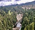
Retaruke River gorge at Ngamoturiki

