List of volcanoes in New Zealand facts for kids
New Zealand is a country known for its amazing landscapes, and many of these features were created by volcanoes! This article lists some of the active, dormant (sleeping), and extinct (no longer active) volcanoes found in New Zealand and its surrounding areas.
Underwater Volcanoes: Kermadec Arc and Havre Trough
Deep under the Pacific Ocean, off the coast of New Zealand, there's a long chain of underwater volcanoes called the Kermadec Arc and the Havre Trough. These areas are like a secret world where volcanoes erupt silently beneath the waves.
Some of these underwater mountains, called seamounts, are actually volcanoes! They can be very deep, sometimes thousands of metres below the surface. Scientists study them to learn more about how Earth's plates move and how volcanoes form.
A few notable seamounts in this area include:
- Havre Seamount: This underwater volcano erupted in 2012, creating a huge raft of pumice (lightweight volcanic rock) that floated across the ocean.
- Monowai Seamount: This seamount is quite active and has erupted many times, including in 2008.
- Raoul Island: This is a larger island in the Kermadec group, which is actually the top of a volcano that last erupted in 2006.
North Island Volcanoes
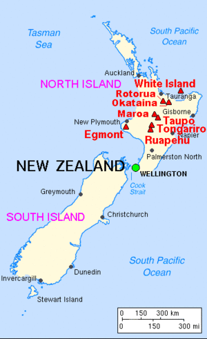
New Zealand's North Island is home to many famous volcanoes, especially in the Taupō Volcanic Zone.
Taupō Volcanic Zone: New Zealand's Fiery Heart
The Taupō Volcanic Zone is a very active area that stretches across the middle of the North Island. It's known for its powerful eruptions and geothermal activity (hot springs and geysers).
Here are some of the important volcanoes in this zone:
- Mount Ngauruhoe: This cone-shaped volcano is part of the Tongariro National Park. It last erupted in 1977.
- Mount Ruapehu: This is the largest active volcano in New Zealand. It's also a popular ski field! Its last eruption was in 2007.
- Mount Tongariro: Another large volcano in the national park, Mount Tongariro had its most recent eruption in 2012.
- Lake Taupō: This huge lake is actually a giant volcanic crater, or caldera, formed by one of the world's most powerful eruptions about 1,800 years ago. It last erupted in 181 AD.
- Mount Tarawera: This volcano is famous for its devastating eruption in 1886, which destroyed villages and created the Pink and White Terraces. It's part of the Okataina caldera.
- Whakaari / White Island: This is an active marine (sea) volcano off the coast of the Bay of Plenty. It last erupted in 2019.
- Rotorua Caldera: Like Lake Taupō, Lake Rotorua also sits in a volcanic crater. The area is famous for its geothermal activity.
- Mayor Island / Tūhua: This island volcano last erupted around 4390 BC.
Other North Island Volcanoes
Beyond the Taupō Volcanic Zone, other volcanic areas dot the North Island:
- Auckland Volcanic Field: The city of Auckland is built on a field of about 50 volcanoes! Most of these are small, cone-shaped volcanoes. The youngest and most famous is Rangitoto Island, which erupted around 1350 AD.
- Mount Taranaki: This beautiful, cone-shaped volcano is on the west coast of the North Island. It last erupted in 1755.
- Kaikohe-Bay of Islands Volcanic Field: This area in Northland has several small volcanoes. Some erupted as recently as 400 years ago.
South Island Volcanoes
The South Island also has its own volcanic history, though most of its volcanoes are much older and are now extinct.
- Banks Peninsula Volcano: This area, near Christchurch, was formed by two large, ancient volcanoes: the Lyttelton Volcano and the Akaroa Volcano. They erupted millions of years ago.
- Dunedin Volcano: The Otago Peninsula, where Dunedin city is located, is the remains of a large volcano that erupted about 10 million years ago.
Other New Zealand Territories
New Zealand also has some remote islands that are volcanic.
- Antipodes Islands: These remote islands in the subantarctic region are volcanic and have had eruptions in recent geological times (Holocene).
- Solander Islands: These islands off the south coast of the South Island are also volcanic.
Ross Dependency: Antarctica's Volcanoes
New Zealand has a special connection to a part of Antarctica called the Ross Dependency. This icy land is home to some incredible volcanoes!
- Mount Erebus: This is the most active volcano in Antarctica and one of the most active in the world! It's located on Ross Island and has been erupting continuously since 1972. It's a truly unique volcano, with a persistent lava lake in its crater.
- Mount Terror: Also on Ross Island, Mount Terror is an extinct volcano that last erupted about 800,000 years ago.
- Mount Bird: Another volcano on Ross Island, Mount Bird last erupted about 3.8 million years ago.
- Balleny Islands: This group of remote, icy islands also has volcanoes, including Brown Peak and Buckle Island, which had eruptions in 2001 and 1899 respectively.
Images for kids
See also
 In Spanish: Anexo:Volcanes de Nueva Zelanda para niños
 | Jackie Robinson |
 | Jack Johnson |
 | Althea Gibson |
 | Arthur Ashe |
 | Muhammad Ali |


