
Mohaka River facts for kids
Quick facts for kids Mohaka River |
|
|---|---|

Mohaka River in Te Haroto
|
|

The Mohaka River (dark blue) and its major tributaries
|
|
| Native name | Mohaka |
| Country | New Zealand |
| Region | Hawkes Bay |
| Physical characteristics | |
| Main source | Kaimanawa Range |
| River mouth | Hawke Bay Mohaka Sea level 39°07′30″S 177°11′38″E / 39.125°S 177.194°E |
| Length | 172 kilometres (107 mi) |
| Basin features | |
| Bridges | Mohaka Viaduct |
The Mohaka River is a beautiful waterway located on the North Island of New Zealand. You can find it in the east-central part of the Hawke’s Bay area. The name "Mohaka" comes from the Maori people. It means "place for dancing."
Several Māori tribes, called iwi, have strong connections to the Mohaka River. These include Ngāti Pāhauwera, Ngāti Hineuru, Ngāti Tūwharetoa, and Mana Ahuriri. The river starts high up in the Kaweka and Kaimanawa mountain ranges. It then flows southeast, twists northeast, and finally heads southeast again. The Mohaka River eventually empties into the Pacific Ocean near the town of Mohaka.
Along its path, the Mohaka River carves out many deep gorges. Some of these rocky canyons are as deep as 200 meters (656 feet)! The main rivers that flow into the Mohaka are the Waipunga, Taharua, and Hautapu rivers. The Mohaka River is about 172 kilometers (107 miles) long. It drains an area of 2,357 square kilometers (910 square miles).
Contents
Mohaka River History
The Ngāti Pāhauwera tribe's traditional land stretches from the Te Hoe river junction to the mouth of the Mohaka. For them, the river, its waters, and its fish are a taonga, which means a special treasure. They believe the river is a very important part of their tribal identity.

Long before European settlers arrived, the Mohaka River was vital for fishing and travel. Archeologists have found many signs of old villages and temporary camps along both the lower and upper parts of the river. The Māori people used to collect special stones from the riverbed for cooking and other uses.
A famous Māori leader named Te Kooti was known to visit this area. You can still see "Te Kooti’s Lookout" from the river. It is said to be the spot where a battle with the British took place. Later, European settlers used the Mohaka River to transport timber (wood).
In 2004, a special rule called a water conservation order was put in place for the upper Mohaka River. This was done because the river has amazing fishing, beautiful gorges, and is great for outdoor activities. It is also a very important home for the rare blue duck. Today, the Mohaka River is a popular place for exciting activities like rafting, kayaking, hiking, and fishing.
River Journey and Features
Upper Mohaka: Kaweka Forest Park

High up in the Kaweka mountain range, the Mohaka River is a winding river with easy to medium rapids (Grade II and some Grade III). In this area, you can find several campsites run by the Department of Conservation (DOC). There are also hot pools and lots of untouched native bush. After about 36 kilometers (22 miles), the river leaves the Kaweka mountains. Here, you start to see more farmland. The river then forms a loop called an oxbow. Soon after, the rapids get bigger as the river enters a more challenging Grade III section. DOC campsites are still available along this 68-kilometer (42-mile) stretch.
Everett's Camp to Te Kooti Bridge
As the river enters the more technical Grade III rapids, it flows past native bush on one side and Waitere Station farmland on the other. This part of the river has Te Hoe’s rapid, which is the biggest and longest rapid in this section. You can also enjoy three beautiful gorges during this journey.
Te Kooti Bridge to Willow Flat

Te Kooti’s Bridge marks the beginning of the very challenging Grade V rapids and the end of the Grade III section. After the bridge, the river is an easy Grade II for about 4 kilometers (2.5 miles). Then, the river banks become steeper, and the rapids begin. The biggest rapid on the entire river, called Long Rapid, is found here. The scenery in this 18-kilometer (11-mile) stretch is amazing. You'll see huge boulders, waterfalls tumbling down steep canyon walls, and cool patterns carved into the soft rocks by the water. The rapids are continuous, mostly Grade III+ with some exciting Grade IV/V sections.
Willow Flat to Mohaka Township

After the Grade V section, the river calms down to Grade II again. It then flows smoothly towards the ocean. You can still see steep river banks and side creeks in this section. These creeks create tall waterfalls and smaller side gorges as they cascade down. The plants along the river become more lush, with many silver ferns (or punga). Closer to the ocean, the land changes to cleared farmland.
River Flow
The water level in the Mohaka River is usually highest in the spring. It naturally gets lower during the summer months. However, the water level can rise very quickly if there are heavy rains. Landslides are common, and sometimes trees can be found floating or stuck between boulders in the river. There is an automatic river gauge that provides information about the water level. You can check this information online (NIWA) or ask local rafting companies for the latest conditions.
Mohaka River Geology

Most of the Mohaka River flows through sedimentary rock. In the upper parts, a type of rock called greywacke often forms the steep banks. Smaller stones and shingle make up the shallow riverbeds and beaches. As you move downstream into the Grade III section, rocks like conglomerate, sandstone, and limestone become more common. Large boulders made of these rocks create the rapids.


Closer to the Grade V section, the boulders get even bigger. The river banks narrow into a deep gorge. Huge conglomerate blocks form the first rapid. Then, the river flows into a canyon made of sedimentary rock. The boulders are impressive not just for their size, but also for the holes and dips the water has carved into them. "House Rock" is worth a closer look; its center has been carved out, and you can only get inside through a hole in the side. You can also find remarkably well-preserved fossilized shells and other ancient organic matter in the stones.
After the Willow Flat Bridge, there are fewer large boulders. Instead, you'll see steep terraces covered in plants. Sandstone and mudstone become more common as the river gets closer to the ocean. Farmland also becomes more widespread.
About seven fault lines cross the Mohaka River. Most are in the upper section. The easiest one to spot is just above a rapid called Red Rock in the Grade III section. You can tell you've crossed a fault because the type of rock changes almost instantly.
Fun Activities on the Mohaka River

Commercial rafting trips are available on all parts of the Mohaka River. You can do a day trip or combine sections for multi-day adventures.
The Mohaka River offers something for every level of kayaking. Beginners will find plenty of calm spots and small waves on the Grade II sections. Intermediate kayakers will enjoy the more challenging Grade III. The Grade V is a very technical run for advanced kayakers. Local rafting companies have the most up-to-date information and can often help you arrange transportation.

The upper section of the Mohaka is the most popular place for fishing in Hawke’s Bay. Trout are a common catch, along with different kinds of native fish. You'll mainly find brown trout above the Pakaututu bridge and rainbow trout below it. Fishing isn't as good on the lower sections, but the rapids there are more exciting!
Hiking is also popular along the upper section. Trails lead to hot springs and give access to the river at various points. The Department of Conservation maintains these trails.
Hunting for sika and red deer, as well as pigs and goats, is common in the area. You will need a permit to hunt here.
Images for kids
-
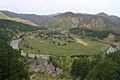
Mohaka bends into an Oxbow. The rock formation called the Organs is near the bottom of the photo.
-
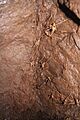
Wētā found in an abandoned gold mine on the Mohaka river.
-

Scenery on the Grade 2 Mohaka River.
-
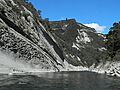
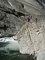
Sedimentary Rock Gorge Mohaka River.
-
Rocks on the Grade 3.
-
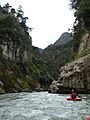
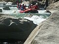
Kayaking the Mohaka.
-
Large Boulders Gr.5 Mohaka River.
-
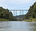
Mohaka Viaduct.


