Gisborne District facts for kids
Quick facts for kids
Gisborne District
Te Tairāwhiti
|
|
|---|---|
|
District and unitary region
|
|
 |
|

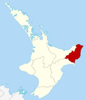
Gisborne within the North Island, New Zealand
|
|
| Country | New Zealand |
| Constituted as local authority district | 6 March 1989 |
| Seat | Gisborne |
| Wards |
List
Matakaoa-Waiapu
Waipaoa Tawhiti-Uawa Taruheru-Patutahi Gisborne |
| Government | |
| • Body | Gisborne District Council |
| Area | |
| • Land | 8,385.29 km2 (3,237.58 sq mi) |
| Population
(June 2023)
|
|
| • Territorial | 52,600 |
| • Urban | 38,200 |
| GDP | |
| • Total | NZ$ 2.690 billion (2021) |
| • Per capita | NZ$ 51,833 (2021) |
| Area code(s) | 06 |
| HDI (2021) | 0.893 very high · 15th |
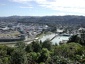
The Gisborne District (also called the Gisborne Region) is a special area in the northeastern part of New Zealand. Its Māori name is Te Tairāwhiti or Te Tai Rāwhiti. This region is managed by the Gisborne District Council. This council acts like both a local district and a regional council.
The region is named after its biggest town, Gisborne. People often call this area the East Coast. It has mountains to the west and rough land to the south. To the east, it faces the wide Pacific Ocean.
Contents
Discovering Gisborne's Name and History
Before the late 1800s, this area was known as Tūranga. When the town of Gisborne was planned in 1870, its name changed. It was named after William Gisborne, who was a Colonial Secretary. This new name also helped avoid confusion with another town called Tauranga.
Understanding Regional Names
The region was once known as the East Coast. Today, it's often split into two parts. The "East Coast proper" (or East Cape) is north of Gisborne city. Poverty Bay includes the city and the land around it. Sometimes, the whole region is called the East Cape. However, this name also refers to a specific point at the very northeast end.
More recently, people have started calling it Eastland. This name can sometimes include Ōpōtiki in the eastern Bay of Plenty and Wairoa to the south.
The Meaning of Te Tai Rāwhiti
The Māori name for the region is Te Tai Rāwhiti. This beautiful name means "the Coast of the Sunrise." It's called this because it's the first part of mainland New Zealand to see the sun rise each day. The Gisborne District Council uses the name Te Tairāwhiti.
Exploring Gisborne's Geography
This region is found in the northeastern corner of the North Island. It stretches from the Wharerata Hills in the south to Lottin Point in the north. The Wharerata Hills separate it from the Wairoa District in Hawke's Bay. The western border follows the Raukumara Range, which divides it from the Ōpōtiki District. In the southwest, the boundary runs along the edge of Te Urewera.
Population and Settlements
Gisborne District is not very crowded. Most people live in small towns along the eastern coast. These include places like Tokomaru Bay and Tolaga Bay. About three-quarters of the region's population lives in Gisborne city. No other towns have more than 1,000 people. The largest towns outside Gisborne are Tolaga Bay and Ruatoria.
Inland Landscapes and Mount Hikurangi
Inland, the land is rugged and mostly covered in forests. A line of rough hills runs through the middle of the region. The highest point is the impressive Mount Hikurangi, which is 1,752 meters tall. It's located in the Waiapu Valley in the northeast. Hikurangi is the fifth-highest mountain in the North Island. It's also the highest one that isn't a volcano.
Māori people consider Mount Hikurangi to be sacred. Many believe it is the first mountain in the world to see the sun rise in summer.
Māori Culture and Iwi
The Gisborne region has a higher percentage of Māori people than the rest of New Zealand. In some areas, over 50% of the population is Māori. The community here has strong connections to Māori traditions. They also have strong ties to their iwi (tribes) and marae (meeting grounds). The main iwi in this area are Ngāti Porou, Rongowhakaata, Ngāi Tāmanuhiri, and Te Aitanga-a-Māhaki.
Understanding the 2007 Earthquake
On December 20, 2007, at 8:55 PM, the Gisborne region experienced an earthquake. It had a magnitude of 6.8. The earthquake's center was about 50 kilometers southeast of Gisborne. It was 40 kilometers deep in the Hikurangi Margin.
The shaking was strong, causing damage to buildings. Three buildings in the city center collapsed, and others were damaged. Sadly, one elderly woman died from a heart attack during the quake. There were also a few minor injuries.
Gisborne's Climate
The Gisborne region has a dry and sunny climate. This is because high mountains to the west protect it. The region gets about 2,200 hours of sunshine each year. Rainfall changes depending on the area. Near the coast, it's about 1,000 mm per year. In the higher inland areas, it can be over 2,500 mm.
In summer, the temperature usually ranges from 20 to 28 °C. In winter, it's typically between 10 and 16 °C. Nighttime temperatures in summer are 10 to 16 °C. In winter, they can drop to 0 to 8 °C.
| Climate data for Gisborne | |||||||||||||
|---|---|---|---|---|---|---|---|---|---|---|---|---|---|
| Month | Jan | Feb | Mar | Apr | May | Jun | Jul | Aug | Sep | Oct | Nov | Dec | Year |
| Mean daily maximum °C (°F) | 24.9 (76.8) |
24.2 (75.6) |
22.6 (72.7) |
19.9 (67.8) |
17.1 (62.8) |
14.7 (58.5) |
14.1 (57.4) |
14.9 (58.8) |
16.8 (62.2) |
19.0 (66.2) |
21.3 (70.3) |
23.3 (73.9) |
19.5 (67.1) |
| Mean daily minimum °C (°F) | 13.6 (56.5) |
13.6 (56.5) |
12.2 (54.0) |
9.6 (49.3) |
6.9 (44.4) |
5.3 (41.5) |
4.6 (40.3) |
5.4 (41.7) |
6.8 (44.2) |
8.6 (47.5) |
10.5 (50.9) |
12.3 (54.1) |
9.1 (48.4) |
| Average precipitation mm (inches) | 54 (2.1) |
78 (3.1) |
99 (3.9) |
103 (4.1) |
97 (3.8) |
125 (4.9) |
119 (4.7) |
93 (3.7) |
101 (4.0) |
63 (2.5) |
65 (2.6) |
67 (2.6) |
1,064 (42) |
| Source: NIWA Climate Data | |||||||||||||
Gisborne's Demographics: Who Lives Here?
The Gisborne District covers an area of about 8,385 square kilometers. As of 2018, its estimated population was around 47,517 people. This means there are about 5.7 people living per square kilometer.
| Ethnicity | Population |
|---|---|
| New Zealand European |
28,905
|
| Māori |
28,029
|
| Pasifika |
2,841
|
| Asian |
1,968
|
| MELAA |
381
|
| Other |
468
|
Population Changes Over Time
In the 2023 New Zealand census, Gisborne District had 51,135 people. This was an increase of 3,618 people since the 2018 census. It was also an increase of 7,482 people since the 2013 census. The average age in Gisborne was 36.7 years. This is a bit younger than the national average of 38.1 years.
About 22.2% of the people were under 15 years old. Around 18.8% were aged 15 to 29. The largest group, 42.3%, was aged 30 to 64. About 16.6% of the population was 65 or older.
Ethnicities in Gisborne
The people in Gisborne District come from many different backgrounds.
- About 56.5% identify as European/Pākehā.
- Around 54.8% identify as Māori.
- About 5.6% are Pasifika.
- Around 3.8% are Asian.
- A small number, 0.7%, are Middle Eastern, Latin American, and African New Zealanders.
- About 0.9% identify with other ethnicities.
It's important to remember that people can identify with more than one ethnicity.
Language and Religion
In the 2018 census, most people (77.6%) spoke only one language. About 18.9% could speak two languages, and 1.1% spoke three or more.
When asked about religion, 48.2% said they had no religion. About 36.4% were Christian. Some people (4.6%) followed Māori religious beliefs. Smaller numbers identified as Hindu (0.4%), Muslim (0.2%), or Buddhist (0.3%). About 1.6% had other religions.
Education and Work
Of those aged 15 and older, about 14.9% had a university degree or higher. About 21.9% had no formal qualifications. The average income in Gisborne was $25,900. This was lower than the national average of $31,800. About 10.9% of people earned over $70,000.
Regarding work, 47.1% of people aged 15 and over worked full-time. About 15.0% worked part-time, and 5.2% were unemployed.
Main Urban Areas
Gisborne city is the only large urban area in the district. It has a population of about 37,000 people. This means that about 78% of the district's population lives in Gisborne city.
Other towns and smaller settlements in the Gisborne district include:
- Hicks Bay
- Manutuke
- Patutahi
- Ruatoria
- Te Araroa
- Te Karaka
- Tokomaru Bay
- Tolaga Bay
Gisborne's Economy
The Gisborne region's economy was valued at about NZ$2.16 billion in March 2019. This made up 0.7% of New Zealand's total economy. The average income per person in the region was about $44,004 in the same period.
Arts and Culture in Gisborne
The Gisborne region is home to many talented creative people. These include the famous writer Witi Ihimaera. Also from Gisborne are opera singer Dame Kiri Te Kanawa and actor George Henare.
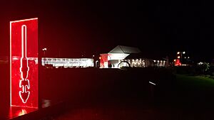
Since 2019, the region has hosted an annual event called the Te Tairāwhiti Arts Festival. In 2020, this festival featured beautiful light displays along the river in Gisborne city. These displays showed off the work of ten local artists.
Sports in Gisborne
In the sport of rugby union, the Gisborne region has two teams. These are the East Coast Rugby Football Union and the Poverty Bay Rugby Football Union.
See also
 In Spanish: Región de Gisborne para niños
 | Mary Eliza Mahoney |
 | Susie King Taylor |
 | Ida Gray |
 | Eliza Ann Grier |


