
Tolaga Bay facts for kids
Quick facts for kids
Tolaga Bay
Uawa (Māori)
|
|
|---|---|
|
Town
|
|

Tolaga Bay
|
|
| Country | New Zealand |
| Region | Gisborne District |
| Ward | Tairāwhiti General Ward |
| Electorates |
|
| Area | |
| • Total | 7.54 km2 (2.91 sq mi) |
| Population
(June 2023)
|
|
| • Total | 930 |
| • Density | 123.3/km2 (319.5/sq mi) |
| Time zone | UTC+12 (NZST) |
| • Summer (DST) | UTC+13 (NZDT) |
| Postcode |
4077
|
| Area code(s) | 06 |
Tolaga Bay (also known as Ūawa in Māori) is a beautiful bay and a small town. It is located on the East Coast of New Zealand's North Island. The town is about 45 kilometres northeast of Gisborne.
The area around Tolaga Bay is quite wild and remote. For many years, the only way to reach the town was by boat. Because the bay is not very deep, a very long wharf was built in the 1920s. This wharf is 600 metres long, making it the second longest in New Zealand. It allowed bigger ships to visit the town. The last cargo ship used the wharf in 1967 to load maize.
Today, Tolaga Bay is a popular place for holidays. Most of the people living here are Māori. It is an important centre for the Te Aitanga-a-Hauiti hapū (a sub-tribe). It is also home to important historical figures like Ariki – Te Kani a Takirau and Tohunga – Rangiuia.
Contents
Exploring Tolaga Bay's Geography
Tolaga Bay is a place with interesting natural features.
Rivers and Islands in the Bay
The Ūawa River flows into the Pacific Ocean right in the middle of Tolaga Bay. There is a sandbar at the river's mouth, which has about 2 metres of water at high tide. Further upstream, the Ūawa River is called the Hikuwai. Other smaller rivers, like the Waiau and the Mangaheia, join it.
In 2018, there were very heavy rains. These rains washed huge amounts of discarded wood from forestry (called "slash") down the Ūawa River. This wood blocked the river's mouth, covered the beach, and caused a lot of damage to local farms and houses.
There is an island in the bay called Pourewa. Captain Cook originally named it Spöring Island. He named it after Herman Spöring, a Finnish botanist who was part of his expedition. Today, it is known by its original Māori name, Pourewa.
Spöring's Arch: A Natural Wonder
The bay also has a cool arched rock. This arch is sometimes called Spöring's Arch. It was drawn by Herman Spöring Jr. during James Cook's voyage in October 1769.
,_built_on_a_perforated_rock,_at_Tolaga_in_New_Zealand_by_Thomas_Morris_and_Herman_Diedrich_Sporing,_1769.jpg)
Local Parks and Sports Grounds
Uawa Reserve is the main sports ground in Tolaga Bay. It is where local teams play and people gather for outdoor activities.
Who Lives in Tolaga Bay?
Statistics New Zealand describes Tolaga Bay as a rural settlement. It covers an area of about 7.54 square kilometres.
Population and People
As of 2018, Tolaga Bay had a population of 831 people. This was an increase of 81 people since the 2013 census. There were 294 households in the town.
The population included slightly more males (423) than females (414). About 26.7% of the people were under 15 years old. The largest age group was 30 to 64 years old, making up 43% of the population.
Most people in Tolaga Bay identify as Māori (86.6%). About 26.7% identify as European/Pākehā. Some people identify with more than one ethnicity.
When it comes to religion, 46.6% of people said they had no religion. About 36.1% were Christian, and 5.4% followed Māori religious beliefs.
For those aged 15 and older, 10.8% had a university degree or higher. About 42.4% of people aged 15 and over worked full-time.
History of Tolaga Bay
Tolaga Bay has a rich history, especially linked to early European explorers and Māori culture.
How Tolaga Bay Got Its Name


Lieutenant James Cook named Tolaga Bay in 1769. The name might have come from a misunderstanding of a Māori word. It could have been "teraki" or "tarakaka," which refer to a local wind. The original Māori name for the area is Uawa Nui A Ruamatua, often shortened to Uawa. Some local people now call the area Hauiti, after the local hapū Te Aitanga-a-Hauiti.
Cook's Visit and Tupaia
When Cook visited, there was a famous school of learning here called Te Rawheoro. This school taught tribal stories and carving. Tupaia, a navigator from Raiatea who was with Cook, met with the tohunga (priest) of this school. Tupaia shared news about the Māori island homelands, which Māori knew as 'Rangiatea' (Ra'iatea), 'Hawaiki' (Havai'i), and 'Tawhiti' (Tahiti). The Māori people saw Tupaia as a tohunga (expert or priest). Many children born during his visit were named after him.
The Wharf's Story
In the 1830s, there was a busy trade in flax involving early European traders. The long wharf, built in the 1920s, became very important for this trade. By 1998, the wharf was in bad condition and almost closed. But the Tolaga Bay Save the Wharf Trust raised money and got help to fix it. The wharf was fully repaired and reopened in May 2013.
Marae: Important Meeting Places
A marae is a special meeting place for Māori people. It is a community area that includes a meeting house and an open space for gatherings. Several marae are located around Tolaga Bay.
Marae South of Town
- Te Rawheoro Marae and Te Rawheoro meeting house: This is a meeting place for the Ngāti Porou hapū (sub-tribes) of Ngāti Patu Whare, Te Aitanga a Hauiti, and Ngāti Wakarara.
- Hauiti Marae and Ruakapanga meeting house: This marae is for the Ngāti Porou hapū of Ngāi Tutekohi, Ngāti Kahukuranui, and Te Aitanga a Hauiti.
Marae North of Town
- Puketawai Marae and Te Amowhiu meeting house: This is a meeting place for the Ngāti Porou hapū of Te Whānau a Te Rangipureora.
- Hinemaurea ki Mangatuna Marae and Hinemaurea meeting house: This marae is for Ngāti Kahukuranui, a hapū of Te Aitanga-ā-Hauiti.
- Ōkurī Marae and meeting house: This is a meeting place for the Ngāti Porou hapū of Ngāti Ira and Ngāti Kahukuranui.
In October 2020, the New Zealand Government provided over $5.7 million to upgrade 29 Ngāti Porou marae. This included Te Rawheoro, Hauiti, Puketawai, and Hinemaurea ki Mangatuna Marae. This funding was expected to create many jobs in the area.
Education in Tolaga Bay
Tolaga Bay has schools that help children learn and grow.
- Tolaga Bay Area School: This is a school for students from Year 1 to Year 15 (ages 5 to 18). It is a state school.
- Te Kura Kaupapa Māori o Mangatuna: This is a Māori immersion school for students from Year 1 to Year 8 (ages 5 to 13). In this school, most of the teaching is done in the Māori language.
Both schools welcome both boys and girls.
Images for kids
-
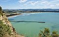
Tolaga Bay with Ūawa River
-
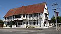
Tolaga Bay Inn, built in 1890


