
East Cape facts for kids
Quick facts for kids East Cape |
|
|---|---|

East Cape on the right hand end of the Raukūmara Range
|
|
| Location | Gisborne District, New Zealand |
| Coordinates | 37°41′21″S 178°32′54″E / 37.6892°S 178.5483°E |
| Offshore water bodies | Pacific Ocean |
| Geology | Cape |
East Cape is the most eastern point of the main islands of New Zealand. It is located at the northern end of the Gisborne District on the North Island. This special place was first named "Cape East" by the famous British explorer James Cook. He explored the area between 1769 and 1779.
East Cape is one of four important "cardinal" capes that Cook named in New Zealand. These capes mark the main directions: North Cape, West Cape, and South Cape. Sometimes, people use "East Cape" to talk about the whole Gisborne District, not just the very tip of the land.
An important landmark here is the East Cape Lighthouse. Maritime New Zealand looks after this lighthouse, which stands right at the easternmost point. Just offshore, you can see a small island called Whangaokeno / East Island, also known as Motu o Kaiawa. To help people visit the lighthouse, the NZ Transport Agency improved the Horoera Bridge in 2017. This upgrade made it easier for campervans and other large vehicles to reach the area.
Contents
Life and Community at East Cape
The East Cape area is a vibrant community that includes towns like Wharekahika / Hicks Bay, Te Araroa, and Tikitiki. This region covers about 991 square kilometers. As of 2023, the estimated population was around 1,509 people.
Population Changes Over Time
The number of people living in East Cape has changed over the years. In the 2023 New Zealand census, the population was 1,509. This was an increase of 120 people since the 2018 census. It also showed an increase of 90 people since the 2013 census. The average age of people living here was about 36.9 years old. Many young people live in the area, with about 384 residents being under 15 years old.
Culture and Languages
East Cape is a place rich in culture and heritage. The community is very diverse. Most residents identify as Māori, making up about 91.7% of the population. There are also European (Pākehā) people, and smaller groups of Pasifika and Asian residents.
English is widely spoken by about 95% of the people. Importantly, the Māori language is also spoken by many, with about 42.1% of residents using it. This shows the strong connection to Māori culture in the region. Some people also follow Christian beliefs or traditional Māori religious practices.
Education and Work
Education is important in the East Cape community. Among adults aged 15 and older, about 10.7% had a bachelor's degree or higher. Many others, about 53.9%, had a certificate or diploma after high school. Around 34.9% of adults had completed high school qualifications.
When it comes to work, about 33.6% of adults aged 15 and over worked full-time. Another 12.3% worked part-time. The median income in the area was $26,700 in 2023. This is lower than the national median income for New Zealand.
Images for kids
-
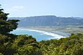
Te Araroa and ranges towards East Cape
-
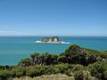
Looking from East Cape towards Whangaokeno / East Island


See also
 In Spanish: East Cape para niños
