
Waimate facts for kids
Quick facts for kids
Waimate
|
|
|---|---|
|
Town
|
|
| Country | New Zealand |
| Island | South Island |
| District | Waimate District |
| Ward | Waimate Ward |
| Electorates |
|
| Area | |
| • Urban area | 8.01 km2 (3.09 sq mi) |
| Population
(June 2023)
|
|
| • Urban area | 3,590 |
| • Density | 448.2/km2 (1,160.8/sq mi) |
| Postcode(s) |
7924
|
| Area code(s) | 03 |
Waimate is a town in Canterbury, New Zealand. It is the main town of the Waimate District. The town is located on the eastern coast of the South Island.
You can reach Waimate by taking a short turn west from State Highway One. This is the main road that runs north and south. Waimate is about 45 kilometers south of Timaru. Timaru is Canterbury's second-largest city. The town is also 20 kilometers north of the Waitaki River. This river forms the border between Canterbury and the Otago province.
Waimate is famous for its Bennett's wallabies. These animals are like small kangaroos. They were brought from Australia a long time ago. Now, they live freely in the countryside around the town. Waimate is also known for the White Horse Monument. This monument is a large white horse shape on the hills behind the town. It honors the strong Clydesdale horses. These horses helped farmers clear the land in the past. From the monument's viewpoint, you can see amazing views of the town. You can also see the green plains of the district stretching to the Pacific Ocean.
Contents
History of Waimate
From 1877 to 1966, Waimate had a railway line. It was called the Waimate Branch. This line connected to the main railway line, the Main South Line. The connection was about seven kilometers east in Studholme. For about 70 years, until 1953, the line went even further. It reached a place called Waihao Downs.
On March 31, 1966, the Waimate Branch line closed. This made Waimate the first major town in New Zealand to lose its railway connection.
Geography of Waimate District
The Waimate District has natural borders. The Waitaki River is to the south. The Pareora River is to the north. The Hakataramea Valley is to the west.
This district is a very good area for farming. Farmers grow crops and raise animals. They also have dairy farms. Some grow fruits and vegetables.
The Waihao River starts in the Hunter Hills. It flows eastwards past the southern side of Waimate town. It then joins with the Waimate Creek. Both rivers eventually flow into the Wainono Dead Arm. This then leads into the Wainono Lagoon near Studholme.
Climate in Waimate
| Climate data for Waimate (1991–2020 normals, extremes 1908–present) | |||||||||||||
|---|---|---|---|---|---|---|---|---|---|---|---|---|---|
| Month | Jan | Feb | Mar | Apr | May | Jun | Jul | Aug | Sep | Oct | Nov | Dec | Year |
| Record high °C (°F) | 36.1 (97.0) |
39.0 (102.2) |
32.5 (90.5) |
30.4 (86.7) |
27.5 (81.5) |
23.0 (73.4) |
21.3 (70.3) |
23.4 (74.1) |
30.0 (86.0) |
32.2 (90.0) |
31.9 (89.4) |
34.8 (94.6) |
39.0 (102.2) |
| Mean daily maximum °C (°F) | 20.4 (68.7) |
20.3 (68.5) |
18.8 (65.8) |
16.4 (61.5) |
14.1 (57.4) |
11.6 (52.9) |
11.0 (51.8) |
11.8 (53.2) |
14.0 (57.2) |
15.6 (60.1) |
17.1 (62.8) |
19.0 (66.2) |
15.8 (60.5) |
| Daily mean °C (°F) | 15.7 (60.3) |
15.5 (59.9) |
14.0 (57.2) |
11.4 (52.5) |
8.9 (48.0) |
6.4 (43.5) |
5.8 (42.4) |
6.8 (44.2) |
9.0 (48.2) |
10.6 (51.1) |
12.3 (54.1) |
14.4 (57.9) |
10.9 (51.6) |
| Mean daily minimum °C (°F) | 11.0 (51.8) |
10.8 (51.4) |
9.2 (48.6) |
6.4 (43.5) |
3.8 (38.8) |
1.2 (34.2) |
0.5 (32.9) |
1.9 (35.4) |
4.0 (39.2) |
5.7 (42.3) |
7.5 (45.5) |
9.8 (49.6) |
6.0 (42.8) |
| Record low °C (°F) | 1.4 (34.5) |
1.0 (33.8) |
−3.0 (26.6) |
−3.2 (26.2) |
−6.2 (20.8) |
−7.5 (18.5) |
−8.5 (16.7) |
−10.0 (14.0) |
−6.5 (20.3) |
−3.3 (26.1) |
−1.7 (28.9) |
0.6 (33.1) |
−10.0 (14.0) |
| Average rainfall mm (inches) | 52.2 (2.06) |
43.5 (1.71) |
35.4 (1.39) |
51.1 (2.01) |
41.8 (1.65) |
37.6 (1.48) |
43.4 (1.71) |
38.7 (1.52) |
35.6 (1.40) |
38.3 (1.51) |
43.2 (1.70) |
43.6 (1.72) |
504.4 (19.86) |
| Source: NIWA | |||||||||||||
People of Waimate (Demographics)
Waimate is a small town. It covers an area of about 8 square kilometers. In 2018, its population was estimated to be around 3,456 people. This means there were about 431 people per square kilometer.
| Historical population | ||
|---|---|---|
| Year | Pop. | ±% p.a. |
| 2006 | 3,288 | — |
| 2013 | 3,285 | −0.01% |
| 2018 | 3,456 | +1.02% |
The population of Waimate grew by 171 people between 2013 and 2018. In 2018, there were more females than males. About 13.7% of the people were under 15 years old. About 33.1% were 65 years or older.
Most people in Waimate are of European descent (94.4%). Some are Māori (7.6%). Smaller groups include Pasifika (0.8%) and Asian (1.7%).
About 12% of the people were born outside New Zealand. This is lower than the national average of 27.1%. Many people (49%) said they had no religion. About 37.8% were Christian.
Nearby Communities
- Glenavy
- Hook
- Hunter
- Ikawai
- Makikihi
- Morven
- Otaio
- Saint Andrews
- Studholme
- Waihao Downs
- Waihaorunga
- Waituna
Economy of Waimate
Like many rural areas in New Zealand, Waimate faced economic challenges in the 1980s. A dairy factory and several sawmills closed down. For about ten years at the end of the 20th century, the biggest employers were two furniture makers. There was also a vegetable processing plant. A factory making French fries and other potato products was in Makikihi.
Most of these businesses closed in the early 2000s. However, new businesses have opened. A large sawmill was built. A big milk powder factory also started operating. These, along with many dairy farms, have brought new confidence to Waimate.
Education in Waimate
There are several schools in Waimate. They serve students from different age groups.
Primary Schools
- Waimate Main School and Waimate Centennial School are primary schools. They teach students from Year 1 to Year 6. Waimate Main School opened in 1867. Waimate Centennial School opened in 1955.
- Waituna Creek School is a rural primary school. It is about 6 kilometers northwest of Waimate. It teaches students from Year 1 to Year 8. This school was started in 1879.
- St Patrick's School is a Catholic primary school. It teaches students from Year 1 to Year 8. The school opened in the late 1880s. In 2005, it celebrated 125 years of Catholic education.
Secondary School
- Waimate High School is a secondary school. It teaches students from Year 7 to Year 13. It opened in 1883 as Waimate District High School. In 1929, it moved to a new location and became Waimate High School. In 1982, it also started taking Year 7 and 8 students.
Notable People from Waimate
Many interesting people have connections to Waimate:
- Eric Batchelor: A brave soldier who served in World War II.
- Ken Catran: A writer of novels and screenplays.
- Margaret Cruickshank (1873–1918): She was the second woman to become a doctor in New Zealand. She was the first New Zealand woman to work as a general practitioner (GP). She spent her career in Waimate. There is a monument in town to celebrate her achievements.
- Mary Gorman: A nurse in World War I. She died when her ship, the SS Marquette, sank.
- A. M. Hamilton: Known for building the Hamilton Road in Kurdistan. He also designed the Callender-Hamilton bridge system.
- Major General Howard Kippenberger: A leader of New Zealand forces in North Africa during World War II. He spent much of his childhood in Waimate.
- Norman Kirk: He was the 29th Prime Minister of New Zealand from 1972 to 1974.
- Neill Rattray (1896–1964): A farmer and war veteran.
- Jim Sheddan (1918–2010): A skilled pilot in the Royal New Zealand Air Force during World War II.
- Michael Studholme: The first European person to settle in this area.
- Sir William Maxwell Manchester (1913–2001): A famous plastic surgeon.
- Kaylee Bell: A New Zealand country singer-songwriter.
Notable Places in Waimate
- Zealandia Statue: A statue of Zealandia is near the main street. Zealandia is a female figure who represents New Zealand. There are only three Zealandia statues in the whole country. The Waimate and Palmerston statues honor soldiers from the Boer War.
- St Patrick's Basilica Catholic Church: This church is on Timaru Road. It was designed in 1908 by Francis Petre. It is considered one of his most unique designs.
- St. Augustine's Anglican Church: This church is on John Street. It was designed in 1872 by Benjamin Mountfort.
- Waihao marae: This is a marae (a traditional Māori meeting ground). It belongs to the Ngāi Tahu tribe. It includes the Centennial Memorial Hall, which is a wharenui (traditional meeting house).
- Waimate Museum: Located on Shearman Street, this building was designed in 1878.
- Arcadia Theatre: This building was first built in 1906 as Quinn's Arcade.
- Waimate White Horse: This famous landmark is also located in the town.
Sports in Waimate
- Rugby: The Waimate Rugby Football Club has teams that play in local competitions.
- Golf: The Waimate Golf Club offers a place for golf enthusiasts.
Events in Waimate
Waimate hosts several annual events:
- March Hare Motorcycle Rally: Held every year on the first weekend of March.
- Waimate 50 Street Race: Takes place in October.
- Waimate Strawberry Fare: An annual event on the second weekend in December.
- Waimate Shears: Held in October.
- Waimate Rodeo: An annual rodeo on December 27.
- Claytons Debating Tournament: Held every year in July or August.
- Waimate Museum Bookarama: An annual book sale at Labour Weekend.
- Waimate Edwardian Heritage Celebrations: Held annually on the second weekend in March.
Movies and Film
- The Waimate Conspiracy (2006) was a movie filmed in Waimate.
Sister Cities
Waimate has sister city relationships with:
- Bourail, France
- Milton-Freewater, USA
Images for kids
-
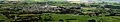
A wide view of Waimate town from the White Horse lookout.
-

A beautiful sunset over the hills south of Waimate.

