Tawa, New Zealand facts for kids
Quick facts for kids
Tawa
|
|
|---|---|
|
Suburb
|
|

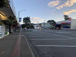
Tawa's main shopping centre, photographed in April 2020
|
|
| Country | New Zealand |
| Local authority | Wellington |
| Electoral ward |
|
| Area | |
| • Land | 552 ha (1,364 acre) |
| Population
(June 2023)
|
|
| • Total | 9,500 |
| Railway station(s) | Takapu Road, Redwood, Tawa, Linden, Kenepuru |
|
|
||
Tawa is a suburb located in the northern part of Wellington city in New Zealand. It's about 15 kilometers north of Wellington's main city area. Tawa sits between the suburbs of Churton Park and Porirua on the North Island.
The name "Tawa" comes from a type of native broadleaf tree that used to grow a lot in this area. Even though the tree is less common now, Tawa is famous for its "Bucket Tree." This is a large macrocarpa tree shaped like an upside-down bucket. Tawa is also known for having many churches from different Christian denominations.
Within Tawa, there are several smaller areas. These include Lindenvale, Westhaven, Redwood, and Southgate to the west. To the east of the central Tawa area, you'll find Linden, Greenacres, and Sundale.
Contents
What is Tawa's geography like?
Tawa is in a wide valley that runs roughly north to south. This valley opens up into the Porirua Basin in the north. The valley is about 4.5 kilometers long and 2.5 kilometers wide. To the east, the Belmont mountain range separates Tawa from the Hutt Valley. To the west, you'll find the Ohariu Valley.
The northern entrance to Tawa is where Kenepuru Drive becomes Main Road. The southern entrance is the Tawa exit of the Johnsonville-Porirua Motorway (State Highway 1). The Porirua Stream flows north through the valley. Many smaller streams, like the Takapu Stream, feed into it.
How do people travel in Tawa?
The North Island Main Trunk railway line follows the Porirua Stream through the valley. This line is part of the Kapiti Line for Wellington's local trains. These trains are run by Metlink. A bit to the east, the Johnsonville-Porirua Motorway (State Highway 1) also runs through the valley. Both the railway and the motorway have been very important for Tawa's growth and for getting around.
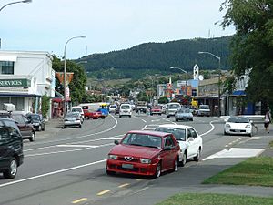
Main Road runs through the middle of Tawa. It connects to all the smaller streets in the suburb. Before the motorway was built in the 1950s, Main Road and Kenepuru Drive were part of State Highway 1.
Tawa has five train stations for passengers: Kenepuru, Linden, Tawa, Redwood, and Takapu Road. Many people from Tawa take the train to Wellington's city center for work every day. Trains are a big part of Tawa's public transport. There are also bus routes that connect Tawa to Porirua and Johnsonville.
In 2009, the Wellington City Council started building a shared path for walking and cycling. This path goes through Tawa to Porirua City Centre. The part of the path in Wellington City was finished in 2013. The part in Porirua City was finished around March 2014.
What is Tawa's history?
Who lived in Tawa first?
The local Māori tribes (called iwi) who have traditional authority over the land in Tawa are Ngāti Toa Rangatira and Taranaki Whānui. These groups have had some land in Tawa and Linden given back to them. This happened as part of a housing partnership with the government.
Even though Māori people didn't live permanently in the Tawa valley, they traveled through it. They used it to go between the communities at Porirua and Te Whanganui a Tara (Wellington Harbour). There was a Māori track that later became the Old Porirua Road in the 1840s. Another track went from Willowbank to the Horokiwi Ridge and Petone.
In the mid-1800s, the New Zealand Company started to settle Wellington. They claimed to have bought the land in Tawa from local Māori. The land was then divided into 100-acre blocks for settlers. Much of the eastern side of the Tawa valley was owned by one family for a long time. In 1951, Tawa and Linden became a Town District. Two years later, it became Tawa Flat Borough.
How did Tawa grow over time?
Tawa's growth has always been closely linked to its transport links. It started as a small farming settlement along the Old Porirua Road. When the road was being built in 1846-47, soldiers used two forts for sleeping and protection. The first settlers had to clear thick forests before they could build and farm.
The first church opened in 1851, and the first school in 1855. But Tawa stayed mostly rural until just before World War II. That's when it started to lose its country feel. Early attempts to create housing areas in 1896 and 1906 didn't get much interest.
A single-track railway line connected Tawa to Wellington from 1885. It went through the Ngaio Gorge and Johnsonville. This line became part of the New Zealand Railways Department in 1908. Tawa's first train station, Tawa Flat station, opened on September 24, 1885.
The Tawa Flat railway changes
From June 1937, a new double-track railway line was built. This was called the Tawa Flat deviation. It went from Thorndon through Kaiwharawhara and two new tunnels to the Tawa valley. This new route was shorter and faster. It cut travel time between Wellington and Tawa by 15 minutes.
The new railway line brought two new train stations. One was at Takapu Road. The new Tawa Flat Railway Station was built on the valley floor. It was about 400 meters north of the old station. The old railway line from Johnsonville to Tawa was closed on June 19, 1937. The line from Wellington to Johnsonville was then updated and became the Johnsonville Branch.
The main railway line was electrified from Wellington to Paekakariki in 1940. This meant trains could run more often. From 1940, the faster electric train service made Tawa a more popular place to live.
Arohata Women's Prison was built at the southern end of Tawa in 1944. It was first a place for young women who had committed crimes. It became a women's prison in 1987.
Fast growth in the 1950s and 60s
Train services got much better and faster in the late 1930s and 1940s. More modern electric trains arrived in the early 1950s. It became quicker and easier for people in Tawa to travel to Wellington for work. Train travel time from Tawa to central Wellington was now shorter than from many other Wellington suburbs.
On December 15, 1957, the railway line from Tawa to Porirua became a double track. A new Linden train station was also built. Two more train stations opened in the 1960s: Kenepuru station in 1963 and Redwood station in 1963. Now, Tawa had five train stations.
During the 1950s, the Johnsonville–Porirua Motorway was built through Tawa. The first part, from Johnsonville to Takapu Road, opened in 1951. This made it much easier to get to Wellington by road. The second part, from Takapu Road to Porirua, opened about five years later. This allowed traffic to bypass Tawa, reducing cars on Main Road.
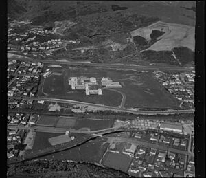
After World War II, many people got married and had children. There weren't enough new houses in Wellington City. Tawa became a popular place for new homes because it was easier to get to. The land in Tawa was also flatter and had gentler hills than other parts of Wellington. Tawa also has a slightly warmer climate sometimes. All these things made Tawa grow very quickly.
More schools were needed because the population was growing. A new primary school opened in Linden in 1952. Tawa College opened in 1960, so students didn't have to travel to Porirua or Wellington for high school. St. Francis Xavier School, a Catholic primary school, opened in Redwood in 1960. Hampton Hill School opened in 1965, and Redwood School in 1966.
Tawa from the 1970s to today
In the 1970s, Tawa continued to grow a lot, especially in Redwood and parts of Sundale. To help with this growth, Greenacres primary school opened in 1972. Tawa Intermediate opened in 1975. This school took students from Year 7 and 8, which helped the primary schools.
Since the 1990s, Tawa has been growing more slowly. Most of the new housing has been built to the east of the Motorway. This growth has spread towards the Takapu Valley.
While new housing areas have slowed down, many existing properties are being divided into smaller sections. Some old industrial areas in Tawa have also been redeveloped. For example, Dress Smart, an outlet shopping center, was built. A retirement village called Redwood village was also developed. A new supermarket opened in 2012. In 1999, Tawa voted to allow alcohol sales for the first time. Since then, several pubs and bars have opened.
Who lives in Tawa?
Tawa covers about 5.52 square kilometers. As of 2023, it has an estimated population of around 9,258 people. This means there are about 1,677 people living per square kilometer.
In 2018, Tawa had 9,258 people living there. This was an increase of 360 people since 2013. There were 3,159 households. There were slightly more females than males. About 19.5% of the people were under 15 years old.
Most people in Tawa are of European background (73.2%). Other groups include Māori (9.9%), Pasifika (8.1%), and Asian (17.6%). About 30.4% of people were born outside New Zealand.
When asked about religion, 44.6% said they had no religion. 41.3% were Christian. Other religions included Hindu, Muslim, and Buddhist.
About 31.2% of people aged 15 or older had a university degree. 53.4% of people aged 15 or older worked full-time.
What schools are in Tawa?
Primary schools
- Tawa School is a state primary school for students in Year 1 to 8. It has about 500 students.
- Hampton Hill School is a state primary school for students in Year 1 to 8. It was started in 1965.
- Greenacres School is a state primary school for students in Year 1 to 6. It was started in 1972.
- Redwood School is a state primary school for students in Year 1 to 6. It was started on February 2, 1966.
- St Francis Xavier School is a state-integrated Catholic primary school for students in Year 1 to 6. It was started in 1960.
Intermediate and secondary schools
- Tawa Intermediate is a state intermediate school for students in Year 7 to 8. It was started in 1975.
- Tawa College is a state secondary school for students in Year 9 to 13. It was started in 1961.
What churches are in Tawa?
Tawa has many different churches and religious groups. These include:
- Tawa-Linden Anglican Church
- Tawa Baptist Church
- Our Lady of Fatima Catholic Church
- Church of Jesus Christ of Latter Day Saints
- Gospel Hall
- Samoan Methodist Parish
- New Life Church
- Salvation Army
- Tawa Samoan Assembly of God
- Tawa Union Church
There is also a Christadelphian group in Linden. A traditional Catholic chapel is also in Tawa. In 2011, a Buddhist meditation center called Dhamma Gavesi was set up in Tawa.
What facilities does Tawa have?
Community places
Tawa has many community facilities. The Mervyn Kemp Library was updated in 2002. It's on the corner of Main Road and Cambridge Street. The Tawa Community Centre is also on Cambridge Street. The Tawa Recreation Centre opened in 2004. It's at Tawa College and is a partnership between the college and the Wellington City Council. The Tawa Pool is on Davies Street. It has a 25-meter heated indoor pool, a learner pool, a toddler pool, a spa, and a sauna.
Shopping areas
Most of Tawa's shops and businesses are along Main Road. The part of Main Road between Lyndhurst Road and Lincoln Avenue is Tawa's main village center. Here you can find supermarkets, post services, pharmacies, medical centers, dentists, banks, and many restaurants and takeaway shops. There's also a smaller shopping area near Linden Station.
Sports facilities
Tawa has many community-run sports facilities. Next to the Tawa pool is the Tawa Bowls club. The North Wellington Badminton Association has a large stadium with 6 courts on Tawa Street. Also on Tawa Street is the Tawa-Lyndhurst Tennis Club, which has 8 tennis courts.
Tawa has several Rugby Union fields, with Tawa Rugby located at Lyndhurst park. There are also several Cricket fields, including Linden Park. The Tawa Squash club is on Main Road. Tawa has several Football fields. The clubroom is shared with the Tawa Softball Club. Tawa is also home to the Tawa Mah Jong Club and the Kapi Mana Bridge Club.
Parks
Tawa has many parks, both landscaped and natural. Many of these parks have play areas and open spaces. The Porirua Stream flows through several of these parks. Local community groups, like the Friends of Tawa Bush Reserves, work with the council to protect Tawa's natural areas and parks.
Who are some famous people from Tawa?
- Ashley Bloomfield - A former top health official in New Zealand.
- Jerry Collins - A famous All Blacks rugby captain.
- Sophie Devine - A well-known cricket and hockey player for New Zealand.
- Amelia Kerr - A cricket player for the New Zealand women's team.
- Jess Kerr - Also a cricket player for the New Zealand women's team.
- Murray Mexted - A former All Black rugby captain.
- Kerry Prendergast - A former Mayor of Wellington.
- Lee Tamahori - A film director.
Tawa in stories
The comedian Ginette McDonald created a character called Lynn of Tawa. This character became very famous in New Zealand in the 1970s. McDonald's character made fun of typical middle-class suburban life in New Zealand.
 | Dorothy Vaughan |
 | Charles Henry Turner |
 | Hildrus Poindexter |
 | Henry Cecil McBay |


