
Thorndon, New Zealand facts for kids
Quick facts for kids
Thorndon
|
|
|---|---|
|
Suburb
|
|

Thorndon in front of Kelburn and
Te Ahumairangi Hill. Karori in the distance |
|

Thorndon
Location in New Zealand
|
|
| Country | New Zealand |
| Local authority | Wellington City |
| Electoral ward |
|
| Established | 1840 |
| Area | |
| • Land | 149 ha (368 acre) |
| Population
(June 2023)
|
|
| • Total | 4,390 |
| Railway station(s) |
|
| Ferry terminal(s) | Wellington Interislander Terminal, Wellington Bluebridge Terminal |
|
|
||


Thorndon is a very old and important part of Wellington, the capital city of New Zealand. It's known for being flatter than other parts of Wellington, which is a very hilly city! Because of this, it used to be where many important and wealthy families lived.
Before it was called Thorndon, this area was known as Haukawakawa. In 1824, a Māori village called Pipitea Pā was built here. Later, some land and the Pipitea Marae (a special meeting place for Māori) were separated from Thorndon. They were given back their original name, Pipitea, in 2003.
Today, Thorndon is home to the New Zealand government. It also has many nice homes. It sits at the northern end of Wellington's main city centre.
Contents
A Look Back: Thorndon's History
The name Pipitea might come from the pipi (a type of shellfish) beds that were once found along Thorndon Quay.
Early Māori Settlements
In 1824, the Ngāti Mutunga people from Taranaki built a fortified village called Pipitea Pā. This was on the flat land of Haukawakawa. In 1835, the Ngāti Mutunga left for the Chatham Islands. Then, the Te Āti Awa people moved into the pā.
After European settlers arrived, the pā became less active. However, some people continued to live there into the 1900s. There were also other small villages nearby. The gardens of Pipitea Pā stretched all the way to where Parliament and the Botanic Garden are today.
Pipitea Marae Today
In 1980, part of the pā site became an urban marae. A marae is a special place for Māori culture and meetings. In 2009, this land was officially returned to the Te Āti Awa and Taranaki whānui (wider family groups) as part of a Treaty of Waitangi settlement.
Pipitea Marae and its meeting house, Te Upoko o te Ika a Māui, are important gathering places for these Māori groups.
European Arrival and Naming
Thorndon was one of the first places in Wellington where European settlers built their homes in 1840. This was because it was one of the few flat areas near the harbour. Early descriptions called it "the court end of town," meaning it was a fancy area.
The New Zealand Company named the flats Thorndon. They named it after the estate of W. H. F. Petre, who was one of their directors.
Who Lives in Thorndon?
Thorndon covers about 1.49 square kilometres. As of 2023, around 4,000 people live here. This means there are about 2,700 people for every square kilometre.
Population Changes
The number of people living in Thorndon has grown over the years:
- 2006: 3,477 people
- 2013: 3,687 people
- 2018: 4,020 people
In 2018, there were 1,860 households. There were slightly more females (2,097) than males (1,923). The average age was about 33 years old. About 7.8% of residents were under 15 years old.
Diverse Community
Thorndon is home to a mix of people from different backgrounds:
Many people in Thorndon were born overseas, about 36.6% of the population.
Education and Work
Many people in Thorndon have a university degree or higher. About 59% of adults have a bachelor's degree or more. The average income in Thorndon is higher than the national average. Most adults work full-time.
Important Buildings in Thorndon
Thorndon is a very important place for New Zealand's government and history.
Government and Law
The New Zealand Parliament Buildings are located here. This is where the country's laws are made. Thorndon also has important courts, like the Appeal Court and the High Court. The Supreme Court is also very close by.
Other important national places include the National Library and Archives New Zealand. These places keep important books, documents, and records for the country.
Museums and Cathedrals
The national museum, Te Papa Tongarewa, used to be in Thorndon. It moved to a new, much larger building by the harbour in 1998.
Thorndon is also home to two large cathedrals:
- The Anglican Wellington Cathedral of St Paul. It was built over many years, from 1937 to 1998. It replaced an older church, which is now known as Old St Paul's.
- The Roman Catholic Sacred Heart Cathedral. It opened in 1901.
The Thistle Inn is also in Thorndon. It is one of the oldest pubs in New Zealand.
Thorndon's Location
.jpg)
Thorndon is at the northern end of Wellington's main flat area, which stretches along the coast. Green hills surround it: Wadestown to the north, and Northland and Kelburn to the west and south. To the east are the port facilities of Wellington Harbour. Thorndon now also includes Te Ahumairangi Hill.
The shape of Thorndon on a map is like a rough triangle. Its borders wind through streets like Glenmore Street, Thorndon Quay, Hill Street, and Tinakori Road.
Parks and Gardens
Thorndon has several lovely parks and gardens for people to enjoy.
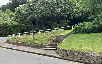
Queen's Park
Queen's Park was created in 1897 to celebrate Queen Victoria's Diamond Jubilee. It has a mix of native New Zealand trees and trees from other countries, including oak trees. You can find a fountain where Grant Road and Wadestown Road meet.
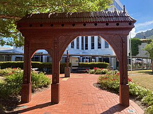
Magyar Millennium Park
This park is also known as the Hungarian garden. It's on the corner of Molesworth Street and Hawkestone Street. It was built in 2003 to celebrate 1,000 years since Hungary became a Christian country. It has paved areas, seats, garden beds, a carved gate, and memorial plaques. It's the only Hungarian monument in New Zealand.
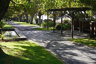
Katherine Mansfield Memorial Park
This park is dedicated to the famous New Zealand writer Katherine Mansfield. It was created in the late 1960s when a new motorway was built. It includes the Lady McKenzie Garden for the Blind, which is designed to be enjoyed by people with visual impairments.
Gallery
- Thorndon parks and gardens
-
Katherine Mansfield Memorial Park, 2021
-
Queen's Park fountain and garden, 2021
-
Magyar Millennium Park carved gate, 2022


Schools in Thorndon
Thorndon is home to several schools:
- Wellington Girls' College
- St Mary's College
- Queen Margaret College
- Thorndon School (primary school)
- Sacred Heart Cathedral School (primary school)
The Central Regional Health School, which helps students who are unwell, is also located in Thorndon.
Fun Events and Sports
.jpg)
.jpg)
Markets and Fairs
Every Saturday, you can visit the Thorndon Farmers Market on Hill Street. It's a great place to find fresh food.
The Thorndon Fair is a big annual event, usually held on the first Sunday of December. It has many stalls selling crafts and second-hand items. The fair helps raise money for Thorndon School. It's a popular community event, and parts of Tinakori Road and Hill Street are closed for it.
Sports Venues
Thorndon's Sky Stadium is one of New Zealand's top sports venues. Many big games and concerts happen here. The Thorndon Tennis (and Squash) Club is also very old, started in the 1800s. It's one of the oldest tennis clubs in the world!
Famous People of Thorndon

Many important people have lived in Thorndon over the years.
Government Leaders
- The Governor-General used to live on Bowen Street.
- The Prime Minister lives at Premier House on Tinakori Road.
- The Speaker of Parliament.
- The Anglican Bishop of Wellington.
- The Catholic Archbishop of Wellington.
Other Notable Residents

Many other well-known people, including merchants, politicians, and artists, have called Thorndon home. Some of these include:
- Harold Beauchamp, a businessman and father of writer Katherine Mansfield.
- William Henry Clayton, a famous architect.
- Katherine Mansfield, a world-famous writer.
- Rita Angus, a very important New Zealand painter.
- Alexander Turnbull, who collected many books and founded the Turnbull Library.
- Robin Cooke, a famous judge who took the suburb's name when he became a life peer.
Many countries have their embassies, high commissions, and consulates in Thorndon. This shows how important Thorndon is for international relations. Countries like the US, China, Germany, Australia, and the UK have their offices here.
Images for kids
-
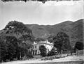
Old Government House Thorndon circa 1877.
-
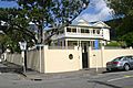
Residence of the Ambassador of France.
-
Robert Pharazyn's house.
-
W H Levin's house in Tinakori Road.
-
Queen Margaret College in 2012.
-

Sydney Street West, showing Rita Angus's cottage.
-
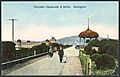
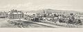
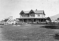
Thorndon Esplanade around 1905.


.jpg)
_(20986497464).jpg)
