
Awatere River facts for kids
Quick facts for kids Awatere River |
|
|---|---|
 |
|
| Native name | Awatere |
| Country | New Zealand |
| Region | Marlborough |
| Physical characteristics | |
| River mouth | Cook Strait 41°36′29″S 174°10′01″E / 41.608°S 174.167°E |
| Length | 110 kilometres (68 mi) |
The Awatere River is a large river in New Zealand. It flows through the Marlborough region. This river is special because it follows the path of an active crack in the Earth's crust, called the Awatere Fault. It runs northeast through a straight valley, next to the Inland Kaikoura mountains. This valley is about 20 kilometers (12 miles) south of the Clarence River.
The Awatere River flows for about 110 kilometers (68 miles). It starts in the mountains and ends in the Cook Strait, near the town of Seddon. The name "Awatere" comes from the Māori language and means "swift river."
The Awatere River Bridge
A long time ago, in 1887, there was no bridge over the Awatere River. It was the only major river without a bridge between Picton and Bluff. People started planning a new bridge in 1896. It was designed to carry both cars and trains. The company Scott Brothers Ltd, from Christchurch, began building it two years later.
Building bridges back then was very different from today. There wasn't much modern technology. Most of the work was done by people and animals. Workers had to lay large foundations called caissons. This was very hard work, as they often had to work in pressurized conditions. The bridge was finished on July 18, 1901. The original bridge, which was 325 meters (1,066 feet) long, opened on October 10, 1902. It took three years to build and cost about £22,500. An extra £118 was spent to add a windbreak to protect trains.
Today, State Highway 1 crosses the Awatere River just north of Seddon. The original bridge was used for both road and rail traffic until 2007. Before 2007, traffic lights were added to control cars because the bridge was only wide enough for one lane.
In 2007, a new two-lane road bridge was built. It cost $15 million and opened on November 9, 2007. Now, the original bridge is used only by trains. The part of the old bridge that cars used to drive on was removed because it was too expensive to keep it open for people walking or cycling.
Images for kids
-
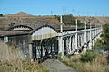
Awatere River rail bridge north of Seddon

See also
 In Spanish: Río Awatere para niños
