
Seddon, New Zealand facts for kids
Quick facts for kids
Seddon
|
|
|---|---|
|
Town
|
|

Awatere Community Centre
|
|
| Country | New Zealand |
| Region | Marlborough |
| Ward |
|
| Electorates |
|
| Area | |
| • Total | 1.66 km2 (0.64 sq mi) |
| Population
(June 2023)
|
|
| • Total | 600 |
| • Density | 361/km2 (940/sq mi) |
| Time zone | UTC+12 (New Zealand Standard Time) |
| • Summer (DST) | UTC+13 (New Zealand Daylight Time) |
| Postcode |
7210
|
Seddon is a small town in the Marlborough area of New Zealand. It is about 25 kilometers (15 miles) south of Blenheim. The town is near where the Awatere and Blind Rivers meet the sea. It is also close to the Lake Grassmere salt works.
Making salt and lime are important jobs in Seddon. The Awatere Valley area is also famous for growing grapes for the Marlborough wine industry. The town was named after Richard Seddon, who used to be the Prime Minister of New Zealand. A Prime Minister is the leader of the country's government.
Contents
What is Seddon Like?
Seddon is considered a rural settlement by Statistics New Zealand. This means it is a small community in the countryside. The town covers an area of about 1.66 square kilometers. As of 2018, about 552 people lived in Seddon.
How Many People Live in Seddon?
The number of people living in Seddon has changed over the years:
- In 2006, there were 495 people.
- In 2013, there were 489 people.
- In 2018, there were 552 people.
This shows that the population grew by 63 people (12.9%) between 2013 and 2018.
Who Lives in Seddon?
In 2018, there were 192 homes in Seddon. There were more males (300) than females (252). About 96 people (17.4%) were under 15 years old. Most people (51.1%) were between 30 and 64 years old.
Most people in Seddon (78.3%) are of European/Pākehā background. Some people are Māori (16.8%) or Pasifika (13.0%). A smaller number are Asian (2.7%) or from other backgrounds. People can choose to identify with more than one group.
When asked about their religion, many people (56.0%) said they had no religion. About 27.7% were Christian. A small number followed Māori religious beliefs, Islam, or other religions.
Most adults in Seddon (57.2%) worked full-time. About 14.5% worked part-time, and 2.6% were looking for work.
Earthquakes in Seddon
Seddon has been near the center of several strong earthquakes.
Past Earthquakes
On October 16, 1848, a very strong earthquake hit Marlborough. Scientists think it was between magnitude 7.4 and 7.7. This earthquake caused a lot of damage. Its center was about 45 kilometers (28 miles) southeast of Seddon.
On April 23, 1966, a magnitude 5.8 earthquake happened. Its center was in Cook Strait, about 40 kilometers (25 miles) east of Seddon. This earthquake was felt very strongly in Seddon. It damaged the chimneys on almost every house in the town.
Recent Earthquakes
In July and August 2013, Seddon was very close to the center of two big earthquakes.
- In late July, a series of strong earthquakes hit the area. The strongest was a magnitude 6.5 earthquake in Cook Strait. People in Blenheim, Wellington, and other parts of Central New Zealand felt these quakes strongly.
- Then, on August 16, 2013, a magnitude 6.6 earthquake struck. Its center was under Lake Grassmere, which is very close to Seddon. This earthquake happened around 2:30 PM. Many smaller quakes, called aftershocks, followed it. Some of these aftershocks were also quite strong. These earthquakes happened just a few years after the very damaging Christchurch earthquakes, which were about 285 kilometers (177 miles) away.
Getting Around Seddon
Roads and Highways
State Highway 1 is a main road that goes through Seddon. This highway connects Blenheim and Christchurch.
Railway History
The railway line, called the Main North Line, reached Seddon from Blenheim in October 1902. When the railway arrived, a special bridge was built over the Awatere River, just north of town. This bridge had two levels: trains used the top level, and cars used the bottom level. The road part of the bridge was used until October 2007. Then, a new two-lane road bridge was opened.
Seddon was the end of the railway line until it was extended to Ward in April 1911. The full railway line all the way to Christchurch did not open until December 1945. Today, you can still take a train called the Coastal Pacific through Seddon. This train runs once a day in each direction during the summer months.
Sadly, a train accident happened near Blind River, south of Seddon, on February 25, 1948. Six people died, and 40 others were hurt.
Learning in Seddon
Seddon School is the only school in the town. It is a school for both boys and girls, teaching students from Year 1 to Year 8 (ages 5 to 13). The school has about 132 students. For high school, students usually go to Marlborough Boys' College or Marlborough Girls' College in Blenheim.
Seddon's Weather
| Climate data for Seddon (1991–2020) | |||||||||||||
|---|---|---|---|---|---|---|---|---|---|---|---|---|---|
| Month | Jan | Feb | Mar | Apr | May | Jun | Jul | Aug | Sep | Oct | Nov | Dec | Year |
| Mean daily maximum °C (°F) | 23.7 (74.7) |
24.0 (75.2) |
22.2 (72.0) |
19.1 (66.4) |
16.5 (61.7) |
14.0 (57.2) |
13.0 (55.4) |
14.1 (57.4) |
16.3 (61.3) |
17.9 (64.2) |
19.5 (67.1) |
22.8 (73.0) |
18.6 (65.5) |
| Daily mean °C (°F) | 17.8 (64.0) |
17.5 (63.5) |
15.8 (60.4) |
13.1 (55.6) |
10.9 (51.6) |
8.4 (47.1) |
7.7 (45.9) |
8.4 (47.1) |
10.5 (50.9) |
12.1 (53.8) |
13.8 (56.8) |
16.4 (61.5) |
12.7 (54.9) |
| Mean daily minimum °C (°F) | 11.9 (53.4) |
11.0 (51.8) |
9.3 (48.7) |
7.1 (44.8) |
5.3 (41.5) |
2.8 (37.0) |
2.3 (36.1) |
2.7 (36.9) |
4.8 (40.6) |
6.3 (43.3) |
8.1 (46.6) |
10.0 (50.0) |
6.8 (44.2) |
| Average rainfall mm (inches) | 53.1 (2.09) |
35.5 (1.40) |
50.6 (1.99) |
30.8 (1.21) |
48.4 (1.91) |
72.5 (2.85) |
74.6 (2.94) |
40.6 (1.60) |
53.5 (2.11) |
48.6 (1.91) |
73.7 (2.90) |
43.2 (1.70) |
625.1 (24.61) |
| Source: NIWA | |||||||||||||
Images for kids
-
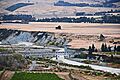
The double decker bridge across the Awatere River
-
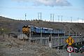
Trains use the upper level of the bridge. Road transport used the lower level until a new bridge was opened in November 2007.


