
Mosgiel facts for kids
Quick facts for kids
Mosgiel
Te Konika o te Matamata
|
|
|---|---|
|
Town
|
|
 |
|
| Country | New Zealand |
| Region | Otago |
| District | Dunedin |
| Community board | Mosgiel-Taieri Community Board |
| Electorates |
|
| Area | |
| • Total | 17.28 km2 (6.67 sq mi) |
| Population
(June 2023)
|
|
| • Total | 14,800 |
| • Density | 856.5/km2 (2,218/sq mi) |
| Time zone | UTC+12 (NZST) |
| • Summer (DST) | UTC+13 (NZDT) |
| Post code |
9024
|
| Area code | 03 |
Mosgiel is a town in Otago, New Zealand. It's like a smaller town connected to the bigger city of Dunedin, located about 15 kilometres west of Dunedin's centre. Mosgiel has a population of around 13,600 people. People sometimes call it "The pearl of the plain" because it's on a flat area. However, being low-lying means it can sometimes flood when there's a lot of rain.
The town got its name from Mossgiel Farm, Ayrshire in Scotland. This farm belonged to the famous poet Robert Burns. His nephew, Reverend Thomas Burns, helped start the Otago settlement in 1848.
Mosgiel is at the edge of the Taieri Plain. A small river called the Silver Stream, which flows into the Taieri River, runs through the northern part of the town. Between Mosgiel and Dunedin are hills like Three Mile Hill and Scroggs Hill. These hills are actually part of an old volcano crater, with Otago Harbour being the crater itself! To the south, you can see Saddle Hill, a well-known landmark with a unique shape.
The Dunedin Southern Motorway connects Mosgiel to Dunedin's city centre. State Highway 87 also starts in Mosgiel, with its first part being the town's main street, Gordon Road.
Contents
Mosgiel's Ancient Stories and Early Days
The area where Mosgiel is located has many interesting Māori legends. Stories tell of ancient canoes, like Tākitimu and Āraiteuru, connected to the Taieri Plain. For example, Maungatua, a large hill to the west, is said to be a huge wave that hit the Tākitimu canoe.
There's also a legend about a taniwha (a water monster or guardian spirit) named Matamata. This taniwha was the guardian of a famous chief. When the chief was lost, Matamata slithered down the Silverstream, creating a hollow where Mosgiel now stands. The taniwha then wriggled down the Taieri River, making its twisty path, and when it died, it became the coastal hills, including Saddle Hill. This story is linked to the Kāti Māmoe people from the late 1600s or early 1700s.
European Arrival and Settlement
In 1770, Captain James Cook described the saddle-shaped hill, which later became known as Saddle Hill. In 1839, the Weller brothers, who ran a whaling station, sent someone to check out the Taieri Plain for a Scottish settlement, but the report wasn't good.
However, in 1846, Charles Kettle surveyed the plain for the Otago Association. He saw the potential for good farming land. After the first settlers arrived in Dunedin in 1848, a shepherd named Jaffray started the first European farm on Saddle Hill in 1849. In the same year, Reverend Thomas Burns chose the land that would become Mosgiel.
In the mid-1850s, Thomas Burns' son, Arthur John Burns, settled on some of this land. The rich soil and the main road nearby led to many people settling in the area.
Growth of the Town
The Otago gold rush in 1861 helped Mosgiel grow, as a new road to the goldfields passed through the area. In 1871, Arthur John Burns started the Mosgiel Woollen Company and a mill, which brought more workers and homes to the settlement.
A railway line was built in 1875, and a branch line was added in 1877. Mosgiel officially became a town district in 1882 and a Borough Council in 1885. The town continued to grow, becoming an important centre for the surrounding farms. Many successful business people built large homes there, and horse racing became popular.
Mosgiel in the 20th Century

From 1900 to 1997, Mosgiel was home to Holy Cross College, a national school for training Catholic priests. The school had large grounds, including a farm. Even though the seminary moved to Auckland in 1997, many of its buildings are still used today.
The flat land near Mosgiel became important for transport in the 20th century. The Taieri Aerodrome (airport) was built north of Mosgiel in the late 1920s. Later, in 1962, Momona Airport, now Dunedin International Airport, was developed further south on the plain.
After World War II, some people thought Mosgiel would become a big industrial area, but it didn't grow as much as expected. The Mosgiel Woollen Mill went bankrupt in 1980 and closed, which was a big change for the town.
In recent years, as New Zealand's population has aged, more housing for older people has been built in Mosgiel, including several retirement villages. The hills above the plain have also seen new homes built. The completion of the Fairfield bypass in 2003 made it quicker to travel to Dunedin city centre.
Mosgiel's economy used to focus on making wool products. Many older New Zealanders still connect the name "Mosgiel" with the old Mosgiel Woollen Mills. Today, Mosgiel's income comes from local shops, cafés, and bars. It's still an important place for farmers in the area to get services. It also has Invermay, one of New Zealand's largest agricultural research centres.
Mosgiel's Population and People
Mosgiel is considered a medium-sized urban area by Statistics New Zealand. It covers about 17.28 square kilometres. As of 2018, Mosgiel had a population of 13,635 people. This was an increase of 11.2% since the 2013 census.
In 2018, there were 5,805 households in Mosgiel. For every 100 females, there were about 87 males.
- 16.3% of the people were under 15 years old.
- 13.5% were aged 15 to 29.
- 40.8% were aged 30 to 64.
- 29.3% were aged 65 or older.
Most people in Mosgiel (93.9%) are of European/Pākehā background. Other groups include:
- 6.8% Māori
- 1.4% Pasifika
- 2.6% Asian
- 2.0% other ethnicities.
About 11.7% of people in Mosgiel were born overseas, which is lower than the national average of 27.1%.
When it comes to religion, about 50.1% of people said they had no religion.
- 40.7% were Christian.
- Smaller numbers followed Māori religious beliefs, Hinduism, Islam, Buddhism, or other religions.
For those aged 15 and older:
- 13.7% had a university degree or higher.
- 27.4% had no formal qualifications.
- 41.8% worked full-time, 14.2% worked part-time, and 2.2% were unemployed.
Places to See and Things to Know

- The East Taieri Presbyterian Church, built in 1870, is a beautiful old church designed by R.A. Lawson. It's located near the Mosgiel turnoff from State Highway 1.
- The Mosgiel Woollen Mill, built in 1871, was the second woollen mill in New Zealand. It was very important to the town and employed many people until it closed at the end of the 20th century.
- In 1936, the famous New Zealand artist Colin McCahon had a special experience looking across the Taieri Plain from the hills. He described it as seeing a "landscape of splendour order and peace," which inspired his art for the rest of his life.
- In 1953, Ralph Hotere, another well-known New Zealand artist, learned to fly planes at the Taieri Aerodrome Training School in Mosgiel.

- Mosgiel has a unique sign that looks like the famous Hollywood Sign in California. The seven letters of the Mosgiel sign are on a hillside near State Highway 1. Because of this, some people jokingly call Mosgiel "Mollywood".
- The distinct shape of Saddle Hill forms the eastern edge of the Mosgiel area.
In recent years, Mosgiel has grown, with more people moving there from Dunedin. New cafés and bars have opened, and a larger playground has been built for kids. In 2010, Mosgiel got the first "Warehouse Local" store, a smaller version of the popular department store.
Schools in Mosgiel
Mosgiel has several schools for different age groups:
- Taieri College is the only state secondary school. It teaches students from Year 7 to Year 13 (ages 11-18). It was formed in 2004 when The Taieri High School and Mosgiel Intermediate merged.
- East Taieri School, Elmgrove School, and Silverstream School are state primary schools for Years 1 to 6 (ages 5-10).
- St Mary's School is a state-integrated Catholic primary school for Years 1 to 8 (ages 5-12).
- Amana Christian School is a private school for Years 1 to 13 (ages 5-18).
All these schools teach both boys and girls.
Famous People from Mosgiel
Many notable people have connections to Mosgiel:
- Steve Hansen, a knighted coach who led the All Blacks rugby team to win the World Cup in 2015.
- Barry Milburn, a New Zealand test cricketer.
- Michael McGarry, a New Zealand footballer.
- Rowan Milburn, a New Zealand and Netherlands women's cricket international.
- Geoffrey Orbell, a doctor famous for rediscovering the takahē, a bird thought to be extinct.
- Brad Thorn, an All Black and Australian rugby league international.
- Ernest John "Midge" Didham, a jockey who won the 1970 Melbourne Cup.
- Thomas Desmond Coughlan, an All Black rugby player in 1958.
- Peter Johnstone, an All Black captain who was undefeated in that role. The local rugby ground is named after him.
- Herbert Paul Sapsford, an All Black in 1976 and a local dentist.
- Peter Renner, an Olympic athlete who competed in the 3,000m steeplechase.
- Kenneth Charles Bloxham, an Otago and All Black rugby player.
- Alister Hopkinson, an All Black rugby player from 1967–70.
- Jenny McDonald, a New Zealand women's hockey player and captain.
- Justin Ives, a rugby international for Japan.
- Bruce Blair, an Otago cricket representative and New Zealand One Day International player.
- Mary Cuddie, an early settler, farmer, and shopkeeper.
Mosgiel's Weather
| Climate data for Mosgiel (Invermay Edr) (1981–2010) | |||||||||||||
|---|---|---|---|---|---|---|---|---|---|---|---|---|---|
| Month | Jan | Feb | Mar | Apr | May | Jun | Jul | Aug | Sep | Oct | Nov | Dec | Year |
| Mean daily maximum °C (°F) | 20.1 (68.2) |
19.4 (66.9) |
18.1 (64.6) |
15.8 (60.4) |
12.9 (55.2) |
10.3 (50.5) |
10.0 (50.0) |
11.5 (52.7) |
13.7 (56.7) |
15.2 (59.4) |
16.9 (62.4) |
18.2 (64.8) |
15.2 (59.3) |
| Daily mean °C (°F) | 14.9 (58.8) |
14.4 (57.9) |
12.9 (55.2) |
10.5 (50.9) |
8.1 (46.6) |
5.8 (42.4) |
5.3 (41.5) |
6.8 (44.2) |
8.8 (47.8) |
10.1 (50.2) |
11.8 (53.2) |
13.4 (56.1) |
10.2 (50.4) |
| Mean daily minimum °C (°F) | 9.7 (49.5) |
9.4 (48.9) |
7.8 (46.0) |
5.2 (41.4) |
3.2 (37.8) |
1.3 (34.3) |
0.6 (33.1) |
2.0 (35.6) |
3.9 (39.0) |
5.0 (41.0) |
6.7 (44.1) |
8.7 (47.7) |
5.3 (41.5) |
| Average rainfall mm (inches) | 82.3 (3.24) |
83.8 (3.30) |
90.1 (3.55) |
43.7 (1.72) |
67.8 (2.67) |
58.2 (2.29) |
70.7 (2.78) |
61.3 (2.41) |
54.3 (2.14) |
68.5 (2.70) |
54.1 (2.13) |
81.7 (3.22) |
816.5 (32.15) |
| Source: NIWA | |||||||||||||
Images for kids
-
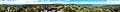
Panorama from the summit of Flagstaff Hill, Dunedin, with Mosgiel on the far left.
-
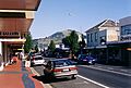
Gordon Road, Mosgiel, with Saddle Hill in the background.
-
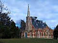
East Taieri Presbyterian Church
-
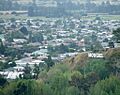
Mosgiel and "Mollywood" sign
