
Taieri Plain facts for kids
The Taieri Plain is a large area of rich farmland located southwest of Dunedin, in Otago, New Zealand. This flat land is also sometimes called the Taieri Plains. It covers about 300 square kilometres, stretching up to 30 kilometres long.
This plain is a flood area for the Taieri River and Waipori River. High hills surround it. To the west are Maungatua and the Silverpeaks Range. To the south and east, there is a low range of hills near the coast.
Contents
What is the Taieri Plain used for?
Farming is very important on the Taieri Plain. Farmers mainly raise dairy cows and sheep. Recently, deer farming has also become a growing business.
Dealing with Floods
Because the land is made of river deposits, floods can happen often. This is especially true where the two rivers meet. To protect the farms, houses, and Dunedin Airport at Momona, special walls called stopbanks have been built.
Part of State Highway 1 crosses the plain on some of these stopbanks. Because of this, people often call this part of the road "The Floodfree Highway."
Interesting Facts About the Taieri Plain
New Zealand's lowest point is found on the Taieri Plain. It is about 2 metres below sea level. You can find this spot slightly north of the airport, on Kirk's Drain Road in Momona.
Towns and Areas on the Taieri Plain
To the northeast, the city of Dunedin is separated from the Taieri Plain by rugged hills. These hills are actually part of an old, extinct volcano.
The town of Mosgiel is at the northeastern edge of the plain. It is officially part of Dunedin city. Other towns and small communities on the plain include Outram, Henley, Allanton, and Momona.
To the southwest, some rolling hills separate the Taieri Plain from other flat areas in South Otago. These areas are around the Tokomairaro River and Clutha River. You can also find two lakes, Lake Waihola and Lake Waipori, within these hills. The Sinclair Wetlands Reserve is also located here, which is a special place for nature.
Images for kids
-
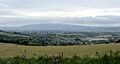
Looking south across the Taieri Plain from above Mosgiel (part of which is visible in the foreground). Maungatua rises above the plain in the distance.
-
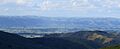
Part of the Taieri Plain as seen from the southeast, in the hills above Lake Waihola
-
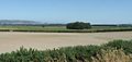
Looking southeast across the Taieri Plain from near Outram.
-
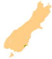
Location of the Taieri Plain


