
Outram, New Zealand facts for kids
Quick facts for kids
Outram
|
|
|---|---|
|
Rural settlement
|
|

Outram from the air
|
|
| Country | New Zealand |
| Island | South Island |
| Region | Otago |
| Territorial authority | Dunedin |
| Community board | Mosgiel-Taieri Community Board |
| Electorates |
|
| Area | |
| • Total | 1.05 km2 (0.41 sq mi) |
| Population
(June 2023)
|
|
| • Total | 880 |
| • Density | 838/km2 (2,171/sq mi) |
| Time zone | UTC+12 (NZST) |
| • Summer (DST) | UTC+13 (NZDT) |
| Postcode |
9019
|
| Area code | 03 |
| Local iwi | Ngāi Tahu |
Outram is a small rural town in New Zealand. It's located about 28 kilometres west of the city of Dunedin. You can find Outram on the edge of the Taieri Plains, near the base of Maungatua mountain. The Taieri River flows close by to the southeast. Outram is also on State Highway 87, which connects Mosgiel and Middlemarch. As of 2018, about 880 people live here.
Contents
Outram's Interesting History
Outram started as a crossing point on a river. This spot was important for people traveling to the goldfields to find gold. The original village had to move after a big flood in the late 1800s. It was rebuilt in its current spot. Outram was also the very first town in New Zealand to have electric street lights!
The Outram Railway Branch
From 1877 to 1953, Outram had its own branch line railway. This railway connected the town to the main rail network. However, as more people started using roads, the railway became less busy. It was eventually closed because there wasn't enough traffic. Today, you can hardly see any signs of the old railway line.
How Outram Got Its Name
The town was named by Sir John Richardson. He named it after Sir James Outram. Sir James was a British general who was famous for his role in the Indian Rebellion of 1857.
Outram on the Big Screen
Outram has even been a filming location for movies!
- In 1935, New Zealand's first "talkie" film (a movie with sound that wasn't a documentary), Down on the Farm, was filmed here.
- Later, in 1982, a short scene from the movie Shaker Run was shot on Outram's main street.
What You Can Find in Outram
Outram has many useful facilities for its residents. These include:
- The Outram Volunteer Fire Brigade, which helps keep the community safe.
- Outram Primary School, where local children go to learn.
- The Outram Library, a great place to find books and information.
- The West Taieri Rugby Club, for sports fans.
- A local church and the Memorial Hall.
- The Outram Hotel, along with a few shops like a cafe and antique stores.
The West Taieri Cemetery is located just outside the town. The Dunedin City Council manages Outram. The town has a water supply system, but it doesn't have a public sewerage system.
Outram's Population and People
Outram is considered a rural settlement by Statistics New Zealand. It covers an area of about 1.05 square kilometres. In 2018, the population was 880. This means there were about 838 people living in each square kilometre.
The population has grown over the years:
- In 2006, there were 645 people.
- In 2013, the population grew to 711.
- By 2018, it reached 774 people.
In 2018, there were 297 households in Outram. There were slightly more males (402) than females (366). About 22.5% of the people were under 15 years old. Most people in Outram (95.7%) identified as European/Pākehā. Some people also identified as Māori (7.8%) or Asian (1.9%).
When asked about religion, most people (60.1%) said they had no religion. About 33.3% were Christian.
Many adults in Outram have good education. About 18% of people aged 15 or older had a bachelor's degree or higher. Most adults were employed, with 52% working full-time and 18.5% working part-time.
Education in Outram
Outram School is a primary school that teaches students from Year 1 to Year 8. As of February 2024. , the school has a roll of 172 students. The school first opened its doors way back in 1861. In 2004, two other schools, Henley School and Momona School, joined with Outram School.
Images for kids
-
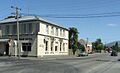
Outram Hotel, a well-known building on the main street of Outram.
-
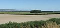
A view looking southeast across the wide Taieri Plains from near Outram.


